

.svg)
GPRS Announces SiteMap 3.0 – Includes Augmented Reality
GPRS Announces SiteMap 3.0 – Includes Augmented Reality
Imagine walking onto your job site or onto the grounds of your facility, pulling your phone out of your pocket, and seeing all your underground utility lines live in real time.
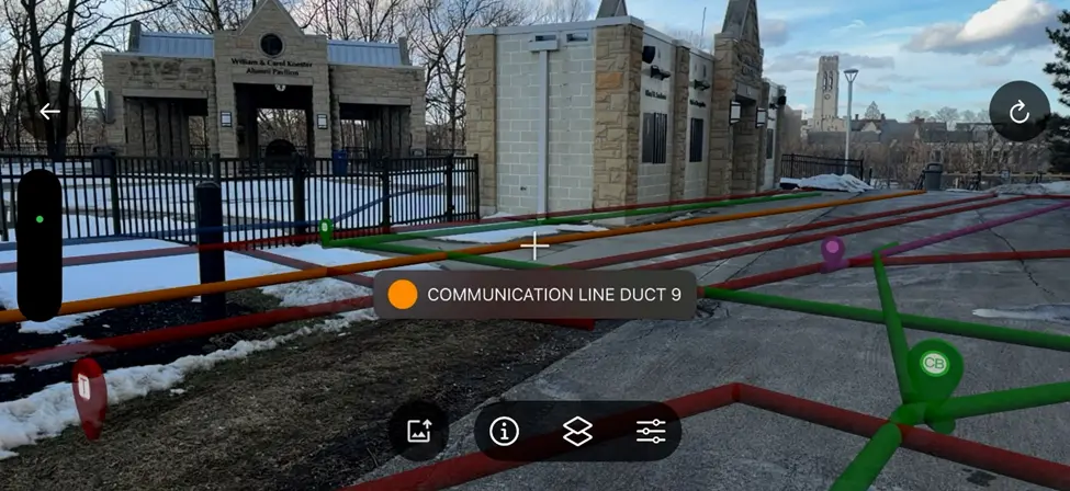
That is the reality – augmented reality – that has just been introduced as part of GPRS’ latest update to its SiteMap GIS platform.
“The augmented reality feature is a particular favorite among construction and facility professionals because it provides instant clarity for all subsurface utilities on any site GPRS has scanned,” was how we put it in our recent press release on SiteMap 3.0. And the AR feature on SiteMap’s Mobile app is just one of a host of major upgrades we’ve made to the platform in the last year.
Other updates include, My Dig Board – a digital excavation collaboration tool, customer self-scheduling GPRS services through SiteMap, line and feature naming customizations, the SiteMap Sewer and Reality Capture layers, and security updates like the new biometric login.
“Construction is inherently dangerous, and no contractor or facility manager should increase risk by working from inaccurate plans. With GPRS providing 99.8% accurate infrastructure data and SiteMap delivering it through a modern software platform, we are helping our clients build and operate more safely,” said GPRS Chief Strategy Officer and SiteMap Executive, Jason Schaff.
You can read the full press release, here.