

.svg)
GPRS provided 2-4 mm accurate reality capture scans of a nearly 100-year-old roller coaster in Rye, New York, to help ensure its preservation.
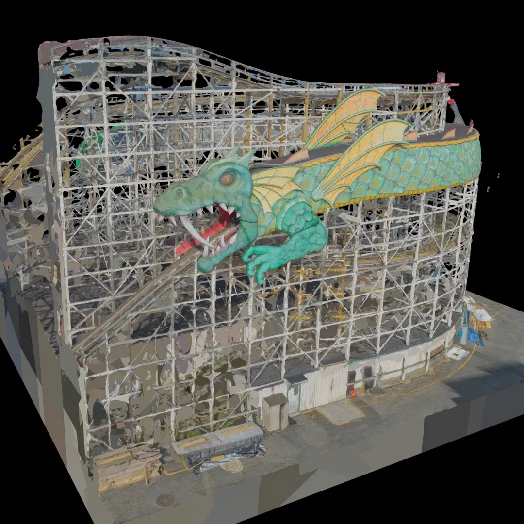
The Dragon Coaster first opened in 1929. The ride got its name because of the large green and yellow dragon that is placed on the tracks and acts as a tunnel. It is prominently featured in Playland Park, which has been recognized as a National Historic Landmark since 1987. The coaster itself is also recognized for its historical significance. The American Coaster Enthusiasts (ACE) designated it as a Roller Coaster Landmark in 2009.
Accurate as-built documentation helps to ensure the safe and efficient preservation of historic landmarks. The client closed the ride for the season and began construction projects. The client requested a full-exterior model of the wooden coaster, which is approximately 80 feet tall and has a track that spans over 3,000 feet.
GPRS Project Managers Rob Donovan and Brett Gonzalez took on the task of scanning the entirety of the iconic attraction.

The size of the ride presented some challenges. A traditional 3D laser scanner wouldn’t be able to capture every part of the roller coaster. GPRS Project Managers most often use terrestrial laser scanners that feature a high-definition LiDAR laser scanner placed on a tripod. To combat this issue, Donovan made the choice to also perform aerial photogrammetry scans using a specialized drone.
3D photogrammetry is different from LiDAR laser scanning. Photogrammetry is the process of capturing many 4K images that are stitched together to create a digital model. LiDAR 3D laser scanners use high-speed light pulses to measure and record precise locations and distances.
While Donovan captured images from the sky, Gonzalez performed LiDAR scans at ground level and even got to go on the tracks to scan the inside of the dragon’s mouth.
.jpg)
Another challenge Donovan faced ended up being some nearby wildlife that took an interest in the drone.
“This isn't the first time this has happened, but there were some birds of prey flying around—some bald eagles—that were very interested in the drone that was flying around their area,” Donovan explained.
Since they were capturing data with the use of 3D laser and photogrammetric scanners, they mapped out survey control points to ensure the scan data and images fit together precisely and are geographically accurate.
GPRS’ in-house Mapping & Modeling team compiled all the scan data and over 800 aerial images to create a full exterior 3D model of the Dragon Coaster.
The GPRS team delivered the models to the client less than a week after they completed the scans. With this model at their fingertips, the client can analyze the structure in tremendous detail to locate any cracks or defects. The model will also serve as a reference when they plan any renovations to preserve the historical landmark.
From fire-breathing amusement rides to centuries-old skyscrapers, GPRS’ reality capture services can be your secret weapon for safely and efficiently capturing your reality and preserving history.
What can we help you visualize?
FREQUENTLY ASKED QUESTIONS
WHAT IS LIDAR?
LiDAR (Light Detection and Ranging) is a remote sensing tool that builds accurate 3D models of objects and surfaces. Instead of using radio waves like radar, LiDAR sends out laser pulses from a scanner. These light pulses bounce off objects, and the system measures how long they take to return. This helps calculate exact distances and shapes. It creates detailed three-dimensional data about an object.
HOW IS 3D LASER SCAN DATA PROCESSED?
Once a site is scanned, we process the raw point cloud data by combining individual scans. We remove unwanted noise and convert the data into usable formats like 2D drawings or 3D models. The level of detail depends on the project’s needs, ranging from basic visuals to complex models. GPRS follows a structured workflow focused on accuracy, teamwork, and planning. We ensure efficient project execution. Our deliverables are high-quality and tailored to each client's needs.