

.svg)
GPRS utilized ground penetrating radar (GPR) to help locate buried time capsules from the early 1900s before a school’s planned demolition.

GPRS Project Manager Dillon Malang was called out to an elementary school in California to help narrow down the search for these time capsules.
“Our sole task was just to try and find these time capsules that were from, I want to say like the 1930s or 40s,” Malang explained.
The school was set for demolition, and members of the community recalled that time capsules were buried somewhere on the property. However, there was no documentation indicating where these capsules were – or if they truly existed at all.
“So, they pretty much narrowed it down to us for like 250-300 square feet areas just to scan with [ground penetrating] radar,” Malang explained.
When GPRS SIM-certified Project Managers utilize GPR for utility locating or concrete scanning, they rely on the imaging that displays when emitting radio signals into the structure. The radio waves “bounce” off any material it encounters and those bounces are displayed as hyperbolas.
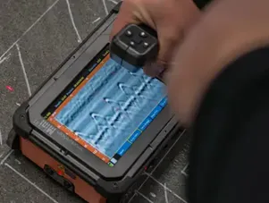
To the untrained eye, it may be unclear what these hyperbolas represent. Our experienced GPRS Project Managers can use this reading to determine the type of material located.
When conducting his investigation, Malang encountered two areas with distinct responses.
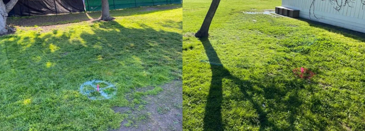
“We're able to find two reactions, one in each area, for them to possibly dig up to try and investigate,” Malang explained.
Malang marked the area with spray paint and flags, so the client will be able to investigate whether any of the responses are the missing time capsules without unnecessary, large-scale potholing.
Locating time capsules isn’t an everyday type of job for GPRS’ nationwide team of Project Managers. Whether we’re helping you preserve a community’s history, or assisting with your commercial construction project, our aim is to give you the accurate, actionable data you need to stay on time, on budget, and safe.
Does GPR Have Any Limitations?
Ground and soil conditions, weather, and type of material located are a few of the potential limiting factors.
An experienced GPR technician, like GPRS Project Managers, will be able to assess a site’s condition to determine if GPR is the proper tool for the job. If GPR is limited by the site conditions or other factors, GPRS Project Managers are equipped with complementary utility locating tools to ensure we can still intelligently visualize your built world.
How Can I Determine if GPR is Needed for My Project?
GPR is commonly used to scan and identify subsurface elements. It’s always wise to conduct a GPR scan before beginning any renovation or demolition activities. This typically includes any excavation work deeper than 18”, or any coring, cutting, or drilling of concrete.
The best way to know whether you need GPR is to contact an experienced GPR technician to evaluate your project and its needs. GPRS’ Project Managers not only know how to use GPR properly and efficiently, they also know when it isn’t the best tool for the job and can recommend what works best for the needs of the clients.
With hundreds of GPRS Project Managers stationed all across the United States, you can be sure that there are quality GPR scanning services near you.
What can we help you visualize?
FREQUENTLY ASKED QUESTIONS
What is Subsurface Investigation Methodology?
Subsurface Investigation Methodology (SIM) is a standard operating procedure and set of professional specifications that work as a guide for utility locating experts when scanning for buried utility lines. All GPRS Project Managers are required to achieve SIM 101 certification, which requires 80 hours of hands-on training in a classroom setting and 320 hours of mentorship in the field. For reference, the American Society for Nondestructive Testing’s (ASNT) minimum training recommendation includes eight hours for training and 60 hours practicing GPR to achieve NDT Level 1 certification in ground penetrating radar (GPR) scanning.
SIM requires the use of multiple, complementary technologies, like GPR scanning and electromagnetic (EM) locating, when locating buried utilities or scanning a concrete slab.
What are the Benefits of Underground Utility Mapping?
Having an updated and accurate map of your subsurface infrastructure reduces accidents, budget overruns, change orders, and project downtime caused by dangerous and costly subsurface damage.