VPI Pipe Inspection guy | GPRS

///BREAKS, DEFECTS & CROSS BORES. WE FIND THEM.

Video Pipe Inspection (CCTV) is a sewer inspection service that uses industry-leading remote video cameras to assess conditions and prevent problems in water, sanitary and storm sewer, and lateral pipelines. Our NASSCO-certified technicians scope your sewers to locate clogs, identify cross bores, find structural defects & damages, and conduct lateral sewer line inspections. GPRS provides comprehensive, interactive reporting that details every inch of your pipes to help you plan repairs, maintain your system integrity, and mitigate risk.
Whats underneath matters | GPRS
Cross Bore Mitigation
Water & Sewer Mapping
Utility Locating
NASSCO Reporting
Manhole Inspections
Mainline Inspections
Lateral Launch
Annual Inspections
Cross Bores | GPRS
Crossbore Mitigation
More than one million cross bores – unknown & unintentional breaches of sewer lines, water lines, and other utilities – exist in the U.S. subsurface infrastructure, and more are added every day.
They cause sewer lateral backups, impact the structural integrity of pipes, and can cause severe damages that include fatal explosions. Hiring GPRS to conduct a video pipe inspection (VPI) ensures that you can find and repair existing cross bores, and prevent new ones by providing contractors with the comprehensive subsurface sewer infrastructure map they need before excavating or installing lines with trenchless technology.
GPRS Equipment in use | GPRS
Mainline Inspections
850 billion gallons of untreated sewage is discharged into U.S. waterways annually. That number does not account for untreated wastewater that leaches into the soil in the event of a cracked, broken, cross-bored, or defective pipe.
GPRS deploys sturdy, robotic mainline crawler CCTV cameras to assess pipe conditions, document all defects, laterals, etc., and map your mainline sanitary and/or storm sewer infrastructure as part of your NASSCO-certified video pipe inspection. Your WinCan VPI report and utility map are securely delivered and accessible 24/7 via SiteMap®, our proprietary project & facility management application. You receive a complimentary SiteMap® Personal subscription when you hire GPRS.
Manhole Inspection | GPRS
Manhole Inspections
Manholes are more complex structures than a typical pipe, so they require special attention to detail. Your GPRS Project Manager will utilize a variety of complementary technologies to gather detailed information, document all defects, and accurately document existing conditions so that you have the information you need to make repairs, maintain your infrastructure, and mitigate risk.
Lateral sewer pipes | GPRS
Sewer Lateral Inspections
Once we have assessed conditions and mapped your mainline water and/or sewer lines, GPRS will investigate all of your lateral lines with a lateral launch camera or a push camera (rodder) to document existing lateral line conditions, locate and report any cross bores, and map your entire water or sewer infrastructure.
Mapping and Modeling VPI | GPRS
Water & Sewer System Mapping
GPRS VPI services enhance a utility locate or full-site scan because we not only find the pipes, we deploy robotic sewer scope cameras, push cameras, lateral launch cameras, and additional technologies to inspect them, document their existing conditions in an interactive, NASSCO-certified report, and include them in a comprehensive, layered utility map, delivered digitally via SiteMap® for your use, 24/7.
Two GPRS employees consulting with a tractor in the background | GPRS
Annual Inspection Programs
Subsurface infrastructure is a complex and ever-changing world – a world that you cannot see without the proper tools and training. That’s why GPRS strongly recommends sewer system inspections every other year to update your existing condition documentation, find new breaks, cross bores, and defects, and protect your system, facility, and community.
NASCO Reporting | GPRS
NASSCO Reporting
All GPRS VPI Project Managers are NASSCO-certified in PACP, LACP, and MACP, along with our required Subsurface Investigation Methodology (SIM) certification, so they are experts in locating, identifying and mapping complex sewer systems, and categorizing pipe defects to provide comprehensive reporting for your needs.

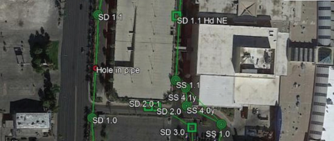
GPRS employs WinCan software in concert with our sewer scope technologies to provide interactive, NASSCO-certified existing condition reporting. GPRS reports include photos and video of each pipe defect, mapped and categorized by type and severity to provide a complete sewer system overview, so that you can repair, maintain, and plan effectively
Utility Locating | GPRS
Utility Locating
On average, 65% off all utility lines – and sewer pipes – at any job site or facility are privately owned.
Your state’s One Call (811) system is responsible for marking all public utility lines. However, they will not mark privately owned lines, and do not provide depths on the public lines they do mark. A comprehensive utility locate that accurately captures both public and private lines is the only way to be sure you won’t suffer a dangerous and expensive utility strike when you drill or dig.

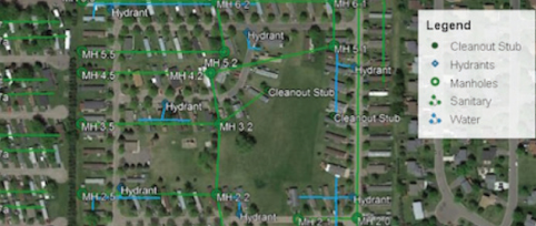
GPRS can locate all private and public utilities, including depths, and provides state-of-the art field markings, complimentary PDF and .KMZ files, and a digitized, layered utility map of your site delivered via SiteMap® – our proprietary project & facility management software application that’s accessible to GPRS customers 24/7.
IN THE UNITED STATES, THERE ARE...
1,000,000
MILES OF POTABLE
WATER PIPING
800,000
MILES OF
PUBLIC SEWERS
500,000
MILES OF PRIVATE 
LATERAL SEWERS

GPRS INSPECTS THEM ALL.

///PROJECT CYCLE SOLUTIONS

GPRS can provide solutions for the entire life cycle of your projects
Project Cycle Solutions Graphic | GPRS

Planning & Design

GPRS can provide existing condition documentation and accurate utility maps for all underground utilities, and can visualize your entire facility, above and below ground, before plans and development are finalized. All our field-verified markings and reports are delivered via SiteMap®, which gives you 24/7 access and secures your data in a single source of truth.

We Intelligently Visualize The Built World® through utility locating, concrete scanning, 3D laser scanning, and leak detection, which can all complement our NASSCO-certified VPI reporting to provide you with accurate as-builts of your entire infrastructure. Our in-house Mapping & Modeling Team can integrate your existing as-builts and even proposed changes to assure accurate measurements and locations of existing assets, to save you time and money.

Construction

Prior to trenching, directional drilling, demolition, and other excavation work during the construction or renovation of your site or facility, it is critical to accurately map and measure all of your above and below-ground infrastructure and assets to develop plans for safe crossing.

When deploying directional drilling and trenchless technologies, it is vital to know how to install lines safely, and also to “check your work” after installation to ensure any cross bores are identified and repaired.

GPRS provides the accurate existing condition documentation and NASSCO-certified reporting you need to complete any excavation and installation project safely.

O&M/Remodel

Renovations, changes & new excavations are a fact of life. GPRS helps you focus your plans with 2-4mm accurate CAD drawings & 3D BIM models that can integrate all of your infrastructure as-builts, and provide you with accurate floor plans via FLRLN, so you can target your workflow safely and efficiently.

///THE RIGHT TOOLS

Mainline Crawler | GPRS
Mainline Crawler
All GPRS Project Managers are experts in utilizing CCTV cameras to investigate sanitary and storm sewers as part of our Video Pipe Inspection Services. Mainline crawlers and their small-diameter crawler cousins are used in concert with push cameras, EM locators, and other technology to provide accurate, comprehensive subsurface visualization and NASSCO-certified reporting.
EM Locator | GPRS
EM Locator
Electromagnetic (EM) locators are the tools preferred by One Call contractors to locate public utility lines. GPRS utilizes EM devices in concert with GPR and our VPI technologies as part of our Subsurface Investigation Methodology (SIM) process to passively detect live AC power or radio signals that travel along conductive utilities. It can also be used to find accessible metallic pipes, risers, or tracer wires.
Sewer Lateral Inspection | GPRS
Lateral Launch
GPRS uses lateral launch cameras as part of a video pipe (CCTV) inspection and/or a full-site utility locate to non-destructively investigate lateral storm and sanitary sewer lines upstream of a mainline to find pipe defects, cross bores, abandoned pipes, and effectively map a sewer system.
Push Camera GPRS | GPRS
Push Camera
Push cameras, also called flexible rodders, can access pipes through smaller spaces than crawlers, like vents, cleanouts, and toilet plumbing to locate small lateral lines in a sewer system. The push camera contains a sonde that can also be detected by a properly programmed EM locator to map non-metallic pipes as part of a full site utility scan or NASSCO VPI report.
Keeping you connected to safety | GPRS
Engineer icon | GPRS
municipalities
The responsibility of managing water, wastewater, and sewer systems is enormous. Every decision you make has the power to impact individuals and communities. And having complete, up-to-date existing condition documentation and as-builts for your sanitary and storm sewer infrastructure help you to make the most informed, efficient, and safe decisions possible. Instead of waiting to react to an emergency, video pipe inspection reporting allows you to take a proactive approach to your system: to plan maintenance and repairs, understand vulnerabilities, and to avoid service interruptions, seepage, and contamination.

Because GPRS VPI reports are delivered digitally via SiteMap®, you, your team, and any contractors you may need have secure, accurate documentation, 24/7 access, and the control you need to meet any situation you may encounter. You receive a complimentary SiteMap® Personal subscription with any GPRS service.
Engineer icon | GPRS
facility managers
Capturing accurate and up-to-date existing conditions for your water, sewer, and overall utility infrastructure can greatly reduce or eliminate utility strikes, which can save you $56,000 per incident, banish service interruptions, and keep everyone at your facility safe. GPRS can provide individual utility locates or full site facility scans in addition to your video pipe inspection – and can encompass your above and below-ground infrastructure to Intelligently Visualize The Built World® with updated, layered, and digitized maps, drawings, models, and reports via SiteMap®.

///INSPECTION PROGRAMS

Cross Bore Inspection | GPRS
Pre & Post-Cross Bore Inspections
We also recommend cross bore inspections that assess pipe locations and conditions prior to the deployment of trenchless technology, and immediately following the installation of any new utilities via trenchless technology to mitigate the risk of cross bores and the dangers they pose.
Contractors Required to Conduct a VPI Inspection Before Utilizing Trenchless Technology

Provides a Baseline for Sewer As Built Information Before Applying Trenchless Technology

Re-Inspection Required Immediately After Applying Trenchless Technology

Mitigates Risk, Damage, And Potential Liability for Your Facility, Campus, or Municipality
Bi-Annual Inspection | GPRS
Annual Inspection Programs
Subsurface infrastructure is a complex and ever-changing world – a world that you cannot see without the proper tools and training. That’s why GPRS strongly recommends periodic sewer system inspections every other year to update your existing condition documentation, find new breaks, cross bores, and defects, and protect your system, facility, and community.
Video Pipe Inspection of Sanitary or Storm Sewer Systems

Reduces/Eliminates Service Interruptions, Contamination Incidents & Damages

Pipe Defects Ranked by Severity in a WinCan Interactive, NASSCO-certified Report

Recommended Every Two Years for Large Facilities, Campuses & Municipalities
A full site scan is incomplete without VPI
When you add a video pipe inspection to your full-site utility locate, we find and map the missing pieces of your subsurface infrastructure.
Hard to locate Sewer Laterals and mains
Unknown manholes and cleanouts
Identify cross bores and pipe defects
When you add a video pipe inspection to your full-site utility locate, we find and map the missing pieces of your subsurface infrastructure.
Mapping and Modeling VPI | GPRSMapping and Modeling VPI | GPRS

///Case Study

GPRS OFFERS COMPREHENSIVE NASSCO REPORTS WITH EVERY VIDEO PIPE INSPECTION
TASK:
Cross Bore Inspection After Fiber Installation
GPRS Pipe camera shot | GPRS
The Bottom Line:
GPRS found 10 sewer cross bores caused by trenchless fiber line installation.
Fremont CA cross bore | GPRSInner pipe image | GPRS
Chat box with question mark | GPRS
Problem
A large telecommunications firm was installing fiber in Fremont, California.

All contractors in the city are required to conduct closed-circuit television (CCTV) inspections of its sewer lines before and after completing any utility installation projects to mitigate the risk of cross bores.

The subcontractor employed by the client pulled out of the job before the post-installation inspections could be completed.
Magnifying glass with check | GPRS
Solution
We utilized our VPI services to inspect the city's sewer system for cross bores.


GPRS uses an arsenal of state-of-the-art video pipe inspection tools to visualize wastewater infrastructure, including lateral launch cameras, robotic CCTV crawlers, and push cameras.


We identifed ten cross bores within the city's system.
Notebook with checks | GPRS
Benefits
Safety: GPRS ensured that our client and the City of Fremont could make the necessary repairs to guarantee the safety of the community.

On Time: Our rapid response kept our client on schedule even after the original subcontractor pulled out of the job.

Reputation: We ensured that our client could complete the requirements set forth by the city. The cross bores were repaired immediately after they were located, so there were no service interruptions for residents.

///BREAKS, DEFECTS & CROSS BORES. WE FIND THEM.

NASSCO is the National Association of Sewer Service Companies. NASCO sets industry standards for assessing, maintaining, and rehabilitating underground water and sewer infrastructure. All GPRS Project Managers are NASSCO trained and certified, and provide NASSCO Video Pipe Inspection Reports via WinCan for our customers, delivered via SiteMap® for secure, accessible documentation that’s available 24/7.

ALL GPRS PROJECT MANAGERS COMPLETE THE FOLLOWING CERTIFICATIONS:
Lateral Assessment Verification | GPRS
Pipeline Assessment & Certification Program (PACP)
The Pipeline Assessment and Certification Program (PACP) is an international standard that has been used for many years as the assessment of pipelines, manholes, and laterals.
Pipeline assessment | GPRS
Lateral Assessment (LACP)
The NASSCO program for defect coding in lateral pipes. This program is the Lateral Assessment and Certification Program (LACP). This training addresses many fittings and access points that are unique to laterals.
Manhole Assessment logo | GPRS
Manhole Assessment (MACP)
The Manhole Assessment and Certification Program (MACP) provides training on the gathering of detailed information to fully document all defects, determine condition of the manhole, and provide the specific information needed to recommend corrective action

///GPRS VIDEO PIPE INSPECTION MAPS, MODELS & REPORTS:

Written NASSCO Reports
GPRS is proud to offer WinCan reporting to our Video Pipe Inspection clients. Maintaining sewers starts with understanding sewer condition, and WinCan allows GPRS Project Managers to collect detailed, NASSCO compliant inspection data.
VPI Report | GPRSVPI Report | GPRS

///GPRS VIDEO PIPE INSPECTION MAPS, MODELS & REPORTS

Detailed Maps & Locations
GPRS Project Managers not only inspect the interior condition of water pipes, sewer pipes, sewer laterals, and manholes – they can provide a map of their location. The GPRS Mapping & Modeling Team can provide detailed GPS overlays and CAD files.
NASSCO Map | GPRSNASSCO Map | GPRSNASSCO Map | GPRSNASSCO Map | GPRS
Detailed Maps & Locations
GPRS Project Managers not only inspect the interior condition of water pipes, sewer pipes, sewer laterals, and manholes – they can provide a map of their location. The GPRS Mapping & Modeling Team can provide detailed GPS overlays and CAD files.
NASSCO image | GPRSNASSCO image | GPRSNASSCO image | GPRSNASSCO image | GPRSNASSCO image | GPRSNASSCO image | GPRSNASSCO image | GPRSNASSCO image | GPRSNASSCO image | GPRSNASSCO image | GPRSNASSCO image | GPRSNASSCO image | GPRS

WATER & SEWER DAMAGE AWARENESS WEEK

Plan - Prevent - Protect | GPRS

From Reactive to Proactive: safe, clean, and profitable Water and sewer systems

Water and sewer damage awareness week | GPRS

ANNUAL SAFETY WEEK THAT FOCUSES ON:

Why our infrastructure is more vulnerable to damage today than ever before.
Keep non-revenue water loss from hurting your community – and your bottom line.
The risks to your systems’ equipment posed by improper/infrequent maintenance.
Learn how to mitigate the risks of cross bores – permanently.
How routine water loss surveys, and proactive water, sewer, and stormwater system maintenance plans eliminate service interruptions and maintain your entity’s reputation.
Create a plan to keep your water, sewer & storm systems running at peak efficiency.

GPRS
INTELLIGENTLY VISUALIZING THE BUILT WORLDTM