industry insights
Featured Articles
Improving and Investing in America’s School Infrastructure
The Difference Between SUE & Private Utility Locating
The History of Geographic Information Systems (GIS) and Their Role in Visualizing Utility Infrastructure
Geographic Information Systems (GIS) have revolutionized the way we visualize, analyze, and interpret data related to the Earth's surface. From its early inception to the sophisticated systems that we use today, GIS technology has become integral in multiple fields, including utility management. This article explores the historical development of GIS and how it has become an essential tool in visualizing and managing utility infrastructure.
The Origins of GIS
Early Developments:
The concept of GIS originated in the early 1960s with the work of Roger Tomlinson, who is often called the "Father of GIS." Tomlinson developed the Canada Geographic Information System (CGIS) to assist in managing land inventory in Canada, marking the first use of GIS in compiling and analyzing geographic data on a large scale.
Technological Advancements:
The development of GIS was closely tied to advances in computer technologies, particularly in terms of data storage, processing power, and graphical display techniques. By the 1980s, as computers became more accessible and powerful, GIS applications began to spread across various fields beyond land management, including environmental sciences, resource management, and urban planning.
Evolution into Modern GIS
The Shift to Digital:
The digitization of maps and the introduction of digital cartography were significant milestones in the history of GIS. These advancements allowed for more dynamic interaction with geographic data, enabling users to manipulate and analyze layers of information effectively.
Integration with Remote Sensing:
Another leap in GIS technology came with its integration with remote sensing data obtained from satellites and aerial surveys. This integration provided GIS users with up-to-date, high-resolution images of the Earth’s surface, enhancing the accuracy and utility of geographic analyses.
The Advent of Internet GIS:
The rise of the internet in the late 1990s and early 2000s transformed GIS from a largely desktop-based application to a more accessible, web-based tool. Online GIS platforms allowed for real-time data sharing and collaboration among users across different locations, significantly expanding the technology’s reach and application.
GIS in Visualizing Utility Infrastructure
Mapping and Monitoring:
In the realm of utility management, GIS is primarily used for mapping and monitoring infrastructure. Utilities such as electricity, water, gas, and telecommunications rely heavily on GIS for the spatial representation of their assets, including pipelines, transmission lines, plants, and service areas. This spatial visualization helps utility companies, facility managers and contractors in planning maintenance, managing outages, and optimizing service delivery.
Integration with Asset Management:
GIS platforms integrate with other information systems used by utility companies, facility managers and contractors, such as asset management and customer information systems. This integration enables the seamless flow of information, allowing for efficient management of resources, quick response to emergencies, and improved service reliability.
Enhancing Predictive Maintenance:
GIS technology facilitates predictive maintenance strategies in utility management. By analyzing geographic data alongside historical data on asset performance and weather patterns, GIS can help predict potential failures and guide proactive maintenance efforts. This not only helps in reducing downtime but also extends the life of the infrastructure.
Supporting Expansion and Compliance:
As utility networks expand to meet growing demand, GIS is crucial in planning and implementing expansion projects. It helps in identifying optimal routes for new lines and assessing environmental impacts, ensuring compliance with regulatory requirements. GIS also plays a key role in public engagement by providing clear, understandable maps and visualizations to communicate project details.
The evolution of Geographic Information Systems from basic mapping tools to complex analytical frameworks has significantly influenced many sectors, with utility management standing out as one of the primary beneficiaries. Today, GIS is indispensable in visualizing and managing utility infrastructure, offering a crucial technological advantage in maintaining, expanding, and optimizing utility services. As GIS technology continues to evolve with advancements in AI and big data analytics, its role in utility management is set to become even more profound, driving efficiency and innovation in the face of growing global demand and environmental challenges.
SiteMap® (patent pending), powered by GPRS, is a cloud-based application for project and facility management that ensures precise documentation of existing conditions to safeguard your assets and personnel. Beyond its inherent GIS functionalities, SiteMap® supports the export of data in various formats such as SHP, GeoJSON, GeoPackage, and DXF, accessible directly from any user account that owns or has access to a shared job. These formats can be integrated into other GIS systems through manual importation by the user.
With SiteMap®, the field-verified infrastructure data gathered by GPRS' SIM and NASSCO-certified Project Managers is readily available around the clock, securely accessible from desktops, tablets, or via the SiteMap® Mobile App.
SiteMap® heralds a new phase in the evolution of GIS technology, equipping you and your team with the tools to plan, manage, excavate, and build better.
GPRS’ SiteMap® team members are currently scheduling live SiteMap® demonstrations. Click below to schedule your SiteMap® demo today!
The Evolution and Future Pathways of the Geographic Information Systems (GIS) Market
The Geographic Information Systems (GIS) market has experienced significant growth and transformation over the past few decades, driven by advancements in technology and an increasing recognition of the technology’s utility in diverse fields such as urban planning, agriculture, emergency response, and beyond.
As we look towards the future, the GIS market is poised to continue its evolution, incorporating emerging technologies and expanding its influence on strategic decision-making across industries.

Current Trends in the GIS Market
Integration with Cloud Computing:
One of the most significant current trends in the GIS market is the integration of cloud technology. Cloud-based GIS solutions offer several advantages, including scalability, flexibility, and cost-effectiveness. They allow for enhanced data storage, processing, and accessibility, which is particularly beneficial for organizations handling large datasets and requiring real-time data access and analysis.
Proliferation of Mobile GIS:
With the increasing use of smartphones and tablets, mobile GIS has become more prevalent. These applications allow field workers in sectors like utility management, forestry, and disaster response to capture, analyze, and share geographic information in real-time, enhancing operational efficiency and decision-making processes.
Focus on Real-time Data and IoT:
The integration of GIS with the Internet of Things (IoT) is enabling real-time geographic data collection and analysis. Sensors and connected devices stream data continuously, allowing for dynamic mapping and monitoring. This real-time capability is crucial for applications such as traffic management, environmental monitoring, and smart city initiatives.
Advanced Spatial Analytics Tools:
There is an ongoing advancement in spatial analysis tools that leverage machine learning and artificial intelligence (AI). These tools can predict patterns and trends, providing deep insights that were not previously possible. For example, AI can help in predictive maintenance of infrastructure by analyzing GIS data alongside historical maintenance data.
Future Trends in the GIS Market
Augmented and Virtual Reality (AR/VR):
Looking ahead, AR and VR are set to transform how GIS data is visualized and interacted with. By overlaying digital information onto the real world (AR) or creating immersive environments (VR), users can understand spatial information in intuitive and impactful ways. This technology could revolutionize training, simulations, and data presentation in fields like urban planning and education.
Greater Emphasis on Sustainability:
GIS is expected to play a crucial role in sustainability efforts around the world, particularly in managing natural resources and mitigating the impacts of climate change. For instance, GIS can help in optimizing land use, conserving water resources, and planning renewable energy projects.
Increased Automation and Smart Technologies:
Automation, driven by AI and machine learning, will increasingly be used to streamline data collection, processing, and analysis in GIS workflows. This will lead to more sophisticated and autonomous GIS applications that can provide insights without human intervention, enhancing efficiency and reducing the possibility of human error.
Expansion into New Industries:
As the versatility of GIS becomes more widely recognized, it will continue to penetrate new markets and industries. Healthcare, for example, can benefit from GIS for epidemiology and managing healthcare services. Similarly, retail businesses are using GIS for site selection, customer segmentation, and supply chain management.
SiteMap® Supports Current & Future GIS Trends
The GIS market is on a dynamic path, with ongoing innovations and expansions that are reshaping how geographic information is used and valued across the globe. As technology continues to evolve, so too will the capabilities and applications of GIS, making it an indispensable tool in our increasingly data-driven world.
This transformation not only promises enhanced operational efficiencies and decision-making capabilities but also contributes significantly to tackling some of the most pressing environmental and societal challenges of our time.
SiteMap® (patent pending), powered by GPRS, is a cloud-based project & facility management application that provides accurate existing condition documentation to protect your assets and people. In addition to offering its own GIS capabilities, SiteMap® allows for exporting of data to SHP, GeoJSON, GeoPackage, and DXF directly from any user’s account that either owns or has a job shared to their account. All these file formats can be imported and utilized by other GIS packages if manually imported by the user.
With SiteMap®, the field-verified infrastructure data collected by GPRS’ SIM and NASSCO-certified Project Managers is at your fingertips 24/7, securely accessible via desktop, tablet, or the SiteMap® Mobile App.
SiteMap® represents the next step in the evolution of GIS technology, allowing you and your team to plan, manage, dig, and ultimately build better.
GPRS’ SiteMap® team members are currently scheduling live SiteMap® demonstrations. Click below to schedule your SiteMap® demo today!
Innovations in Infrastructure: A Deep Dive into SiteMap®-Enabled GIS Utility Mapping Software
Infrastructure has dramatically evolved over the past fifty years.
We've moved from small towns with a few light poles to burgeoning metropolises, and the pace of change shows no signs of slowing. As urban development and transportation networks expand, the effective use of resources and seamless operation of utilities are becoming critical, sometimes even a matter of life or death.
SiteMap® (patent pending), powered by GPRS, is at the forefront of this evolution as a leading provider of utility mapping software. Leveraging Geographic Information Systems (GIS) technology, SiteMap® enables users to visualize, analyze, and manage subsurface utilities with remarkable precision and efficiency. But what sets SiteMap® apart from other solutions?

The Role of Site Mapping Software
Site mapping software is pivotal in infrastructure management, providing a digital platform for visualizing and analyzing spatial data. Traditionally, utility mapping involved labor-intensive manual surveys, paper-based records, and physical inspections. However, the advent of site mapping software has revolutionized this field, offering features like interactive mapping, data integration, and accurate updates. SiteMap® stands out as a premier solution, delivering a comprehensive suite of tools tailored to the unique needs of utility mapping and subsurface infrastructure management.
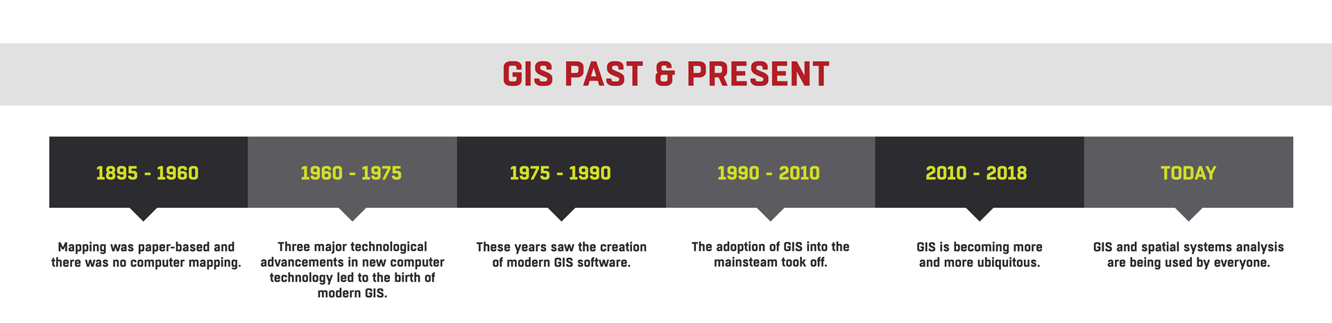
GIS: Past & Present
The history of linking geographic data dates back to 1854 with Dr. John Snow's cholera map in London, which debunked the theory that cholera was airborne and demonstrated it was waterborne, traced to a specific water pump. This pivotal moment not only sparked the field of epidemiology but also highlighted the problem-solving potential of spatial analysis.
From 1854 to 1960, GIS technology saw limited advancements, remaining largely paper-based. It wasn't until the 1950s that maps began to find utility in the vehicle industry, setting the stage for a technological revolution. Between 1960 and 1975, three major technological breakthroughs—map graphics output on line printers, advances in data storage, and the increased processing power of mainframe computers—paved the way for modern GIS.
Roger Tomlinson, dubbed the "Father of GIS," conceptualized the Canadian Geographic Information System (CGIS) during this period, introducing a revolutionary layering approach to map handling. The U.S. Census Bureau and other entities began to digitize and utilize GIS principles, leading to significant developments in digital mapping by 1971.
From 1975 onward, modern GIS software began to emerge, with significant advancements and wider adoption occurring from the 1990s to today, where GIS is ubiquitous across various sectors, driving innovation and problem-solving worldwide.

Features of SiteMap® Utility Mapping Software
- Interactive Mapping Interface: SiteMap® offers an intuitive and user-friendly interface that enables real-time visualization of underground utilities by overlaying different data layers, enhancing decision-making and risk assessment.
- Data Integration and Analysis: SiteMap® not only facilitates seamless data integration but also enhances existing GIS platforms. Depending on the subscription level, users can upload, edit, and analyze utility information, fostering collaboration and optimizing infrastructure planning and operations.
- Mobile Accessibility: Available as a mobile application, SiteMap® enables field personnel to access utility maps and data on-the-go, supported by GPRS technology for precise navigation and real-time data updates.
- Subsurface Utility Mapping (SUE): Although SiteMap® and GPRS do not offer SUE services directly, the technology supports SUE QL-B, providing critical data for avoiding utility conflicts and ensuring safe excavation activities.
The Impact of SiteMap® on Infrastructure Management
The introduction of SiteMap® has transformed infrastructure management, providing a centralized platform for comprehensive data visualization, analysis, and collaboration. This has led to optimized resource allocation, improved project outcomes, and enhanced decision-making across various sectors, including urban development, transportation planning, and utility maintenance.
As infrastructure continues to evolve and expand, SiteMap® remains a significant advancement in the field, representing a comprehensive solution for managing subsurface utilities. With its cutting-edge features, intuitive interface, and dedication to excellence, SiteMap® is set to drive positive change and shape the future of infrastructure management, ensuring our built environment is efficient, resilient, and sustainable.
GPRS SiteMap® team members are currently scheduling live SiteMap® demos. Click below to schedule your demo today!
GPRS helps GC begin New Jersey Sewer Upgrade Safely
It’s exciting when a general contractor places a trailer at a jobsite – because it means they are ready to commence project management and construction.
Mount Construction hired GPRS to perform a utility locate prior to placing a trailer at the Linden Roselle Sewerage Authority. This trailer was their project management headquarters as they undertook construction to upgrade and repair New Jersey’s Linden Roselle Sewage Authority’s water, sewer, and stormwater systems. .
GPRS delivered Mount Construction accurate subsurface utility maps to place their trailer and begin construction planning and execution.
Conducting a utility locate prior to placing a trailer and commencing work is standard practice to ensure the safety of the site, mitigate accidents, and minimize risk. General contractors may not have up-to-date site records with subsurface utility information. A utility locate is typically conducted before placing a trailer (or any structure) to ensure that there are no underground utilities in the area where the trailer will be placed.
A utility locate also helps to prevent damage to underground utilities, which can pose safety hazards if accidentally struck during the placement of the trailer or during construction or excavation. Hitting underground utilities can stop construction work at the Linden Roselle Sewerage Authority and disrupt services, such as electricity, gas, water, and telecommunications.
By identifying and avoiding underground utilities prior to beginning construction work, the risk of project delays and costly repairs is minimized.
By law, unless the underground facility was mismarked, the contractor will be held responsible for all costs resulting from the damage and its repair. Therefore, it is imperative that the utility locate is accurate.
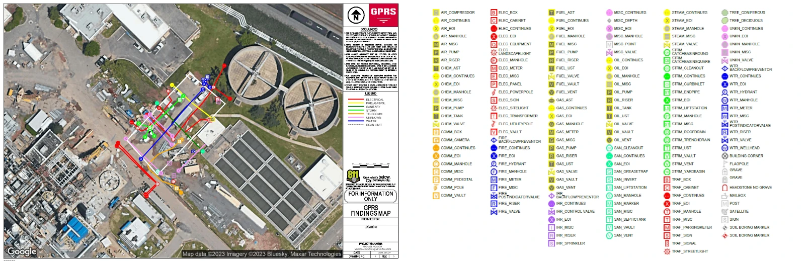
99.8%+ Accurate Utility Maps: It Starts With the Locate
Mount Construction prioritizes safety and efficiency on every project, and that’s why they called GPRS. Project Manager Michael Kovach scanned the site and delivered subsurface as-builts to Mount Construction via SiteMap®.
Kovach scanned a one-acre area at the Linden Roselle Sewerage Authority to locate and mark all underground utilities and find a buried sewer line and it’s buried manhole cover.
Kovach utilized ground penetrating radar and electromagnetic locators to identify the utilities and sewer lines on site, including electric, communication, water, storm sewer, sanitary sewer, and process waste surface obstructions.
“I have completed extensive Subsurface Investigation Methodology training and was able to utilize all my tools and methods to their fullest potential while on site,” said Kovach.
“All lines were found and marked on the surface and recorded on a digital map for the client,” he added. Utility locate maps were quickly uploaded to SiteMap® for the client to access, view, and share.
The Latest Scanning Technology
Kovach used the following equipment to locate and mark the precise locations of utilities on site and create a CAD utility site plan that shows the accurate vertical and horizontal position of underground utility locations.
Ground penetrating radar (GPR) technology identified all underground utilities at the site. This tool is mounted on a stroller frame that rolls over the surface and features an antenna that uses frequencies ranging from 250 MHz to 450 MHz. Subsurface data is displayed on the screen and marked on the surface in real time. The total effective scan depth of GPR can be as much as 8’ and will vary throughout a site depending on a variety of factors such as surface type, surface conditions, soil type, and moisture content. At this site, the maximum effective GPR depth was approximately two feet.
An electromagnetic (EM) locator detected the electromagnetic signals from pipes and cables at the site. EM locators were used to actively trace conductive pipes and tracer wires, and passively detect power and radio signals traveling along conductive pipes and utilities. An electromagnetic radio frequency transmitter sends out a signal in a specific frequency, which transmits through the conductive material in an underground pipe or other piece of infrastructure.
A high-end GPS unit provided accuracy down to 4 inches using the satellite environment at the time of collection. GPS locations can be collected as points, lines, or areas and then exported as a KML/KMZ or overlaid on a CAD drawing.
Kovach’s training provided 99.8% accurate field-verified utility maps, “We can deliver the GPS-enabled utility locate map via SiteMap®, PDF, and .KMZ files to this client.”
SiteMap® is GPRS’ new cloud-based software that quickly and securely delivers 99.8%+ accurate utility maps, images, and drawings of site infrastructure. The Map Viewer allows users to view their facility data on a GIS quickly. The digital plan room hosts every file and map for the site. This client can quickly access the locations of all site utilities, as well as sewer and manhole inspection data.

GPRS Project Managers are required to complete industry-leading Subsurface Investigation Methodology 101 Certification before performing field services on your job site. Every Project Manager completes 80 hours of classroom training and 320 hours of field mentoring to achieve SIM 101 certifications.
Mount Construction is a full-service construction, site improvement, and emergency response service provider in New Jersey. This general contractor offers a suite of vertically integrated services that allow clients to outsource all their water, sewer, and stormwater work to one source, from installations and repairs to emergency service and ongoing maintenance. They specialize in using wet taps and stops to complete new pipe installations, replacements, or system maintenance without shutting down a system. They also perform a range of pipe cleaning operations, specializing in mechanical cleaning and hydro jetting.
The Linden Roselle Sewerage Authority is a 1948-established wastewater treatment and interceptor facility in Linden, New Jersey who also treats and disposes of sewage generated by the municipalities. The Authority’s service area is 13 square miles, it services a residential population of 60,000 and a diverse industrial community, and administers a state approved Industrial Pre-treatment Program.
Why GPRS? The GPRS Difference.
GPRS is in pursuit of 100% subsurface damage prevention. Our 99.8+% accuracy rate demonstrates that our equipment, training, and methodology consistently deliver high-quality results nationwide. All 500+ GPRS Project Managers utilize the industry-leading specification called Subsurface Investigation Methodology when conducting utility mapping, concrete scanning, sewer camera inspection, or 3D laser scanning.
Our commitment to quality and consistency extends to our world-class customer service center. Our team of expert project coordinators, estimators, and account managers strive to provide you with a frictionless experience when hiring GPRS for ground penetrating radar services, utility locating, concrete scanning and imaging, video pipe inspection, or 3D laser scanning. You can expect reliable and consistent service every time you contact GPRS.
What can we help you visualize?
Frequently Asked Questions
How close to utility markings can I dig?
Try to avoid digging on top of or within 18 to 24 inches on all sides of utility marks. Regulations vary by state and locality. In the United States, the Common Ground Alliance (CGA) provides guidelines for safe digging practices, including the "tolerance zone" for different types of utilities. The tolerance zone (the distance you should stay away from utility lines) varies depending on the type of utility. For example, for gas lines, the tolerance zone is usually 18 to 24 inches on either side of the marked utility line. The depth of the utility line also affects how close you can dig. Deeper utility lines may have a wider tolerance zone to prevent accidental damage. The type of excavation equipment and method used can also impact the distance you should maintain from utility lines. Before digging, you should always contact GPRS to mark the location of underground utilities. This helps you avoid digging too close to them.
What is a private utility locate?
A private utility locate is similar to a public utility locate, but it involves identifying and marking private underground utilities on a property. Public utility locates typically involve utilities owned and maintained by public utility companies (such as water, gas, and electric lines). Private utilities, on the other hand, are typically owned and maintained by private individuals or organizations and may include things like private water lines, septic systems, and underground electrical lines that run from a house to a garage or other structure. When planning any digging or construction work on a property, it's important to locate both public and private utilities to avoid damaging them. Private utility locates are often arranged directly with the property owner or through a private utility locating service.
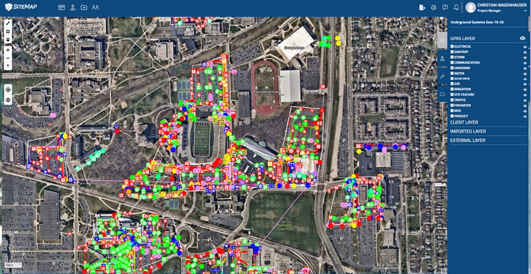
GPRS Conducts Full Site Scan of 112-acre University Campus
College campuses routinely consist of decades-old structures sitting beside new construction and significant renovation projects. Because of this, the underground infrastructure on these properties is a web of both active and abandoned lines.
That was the case as GPRS Project Manager Brian Gifford mapped the infrastructure of a historic college in Pennsylvania, which had no previous documentation of its buried utilities.
Gifford spent nearly two months conducting utility locating and mapping across the college’s 112-acre campus to create accurate as-built documentation that the school’s officials can use for future O&M, renovation, and repair purposes. He then uploaded that data into SiteMap® (patent pending), GPRS’ cloud-based infrastructure mapping software solution where subsurface utility information is secured and accessible 24/7 from a computer, tablet, or mobile device.

“At least a couple of the buildings here are over 100 years old,” Gifford said. “They don’t know where their utilities are located… So that’s kind of the purpose, why we’re out here, is to give them [a map] of all their utilities for the entire campus.”
GPRS is very familiar with the utility locating and mapping needs of our country’s universities. In fact, a couple of years ago we entered a long-term partnership with the University of Toledo (UToledo) where we provide the school with our 99.8% accurate scans and maps of their utilities, gas lines, state-of-the-art video pipe inspection (VPI) of water and sewer pipes, and, ultimately, complete 3D scans and maps of their entire campus, above and below ground.
“I found a lot of old lines,” he said. “There were four water lines running down the campus’ main drive, and two of them were abandoned. They’re cut off in certain spots, but they’re still running through the campus.”
Anytime the university needs to dig – either to renovate or repair – and they’re relying on out-of-date or incomplete as-built utility data, they risk severing a utility line. A single utility strike costs a facility, on average, $56,000 and can take up to eight weeks to repair. On a college campus, that strike can interrupt classes and extracurriculars, and even endanger the lives of faculty and students.

How GPRS Locates and Maps Utilities
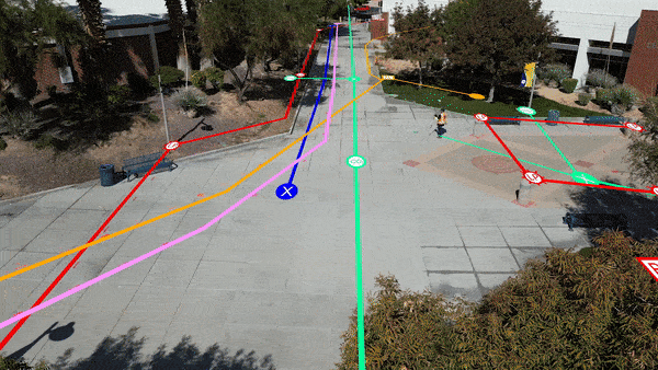
GPRS primarily deploys a combination of ground penetrating radar (GPR) and electromagnetic (EM) locating to locate buried utilities and other underground obstructions.
GPR is a non-destructive detection and imaging technology that uses radio waves to identify subsurface elements either underground or within a surface such as concrete. The GPR scanner emits radio waves into the surface, and then detects the interactions between those waves and buried objects such as electrical conduit, rebar, gas mains, and more.
These interactions – sometimes referred to as “bounces” – appear on a GPR readout as a series of hyperbolas that vary in size and shape depending on the type of material that was located. Professional utility locating specialists like GPRS’ Project Managers (PMs) are specially trained to interpret this data to provide accurate location and depth information that can be used to safely plan excavation projects.
To complement GPR, our PMs also deploy EM locators, which detect the electromagnetic signals radiating from metallic pipes and cables to allow for accurate locating and mapping of those utilities. These signals can be created by the locator’s transmitter applying current to the pipe, or from current flow in a live electrical cable. They can also result from a conductive pipe acting as an antenna and re-radiating signals from stray electrical fields (detected by the EM locator functioning in Power Mode) and communications transmissions (Radio Mode).
Our PMs are trained to utilize the best technology for the job at hand, considering a variety of factors including soil conditions and visible surface features as they plan the best method for providing you with our trademark 99.8%+ accurate utility locating and concrete scanning services. This training is underpinned by Subsurface Investigation Methodology (SIM), the foremost training program and specification for utility locating, concrete scanning, and video pipe inspection.
SIM teaches that the use of multiple locating technologies – including GPR and EM locating – is the best way to ensure a redundant confirmation of investigation results. It also provides our PMs with a step-by-step approach to collecting subsurface data, so their results are repeatable and accurate.
It’s because of this training regimen that PMs like Gifford can tackle a job as big as mapping an entire college campus’ underground infrastructure.
“Generally, we just break the scan area up into sections and take it bit by bit,” he explained. “Move piece by piece... some utilities, I may not be able to find in one location, but then when I move, I can pick it up and trace it back to its source.”
GPRS Project Managers also use GPS and Real-Time Kinematic (RTK) positioning technology to geo-locate their utility locating results. Every GPRS customer receives a complimentary PDF and .KMZ file of their utility map. They also receive a complimentary SiteMap® Personal subscription so that data is at their fingertips where and when they need it.
From skyscrapers to sewer lines, GPRS Intelligently Visualizes The Built World® to keep your projects on time, on budget, and safe.
What can we help you visualize? Click below to schedule a service or request a quote today!
Frequently Asked Questions
What are the Benefits of Underground Utility Mapping?
Having an updated and accurate map of your subsurface infrastructure reduces accidents, budget overruns, change orders, and project downtime caused by dangerous and costly subsurface damage.
How does SiteMap® assist with Utility Mapping?
SiteMap® (patent pending), powered by GPRS, is the industry-leading infrastructure management program. It is a single source of truth, housing the 99.8%+ accurate utility locating, concrete scanning, video pipe inspection, leak detection, and 3D laser scanning data our Project Managers collect on your job site. And the best part is you get a complimentary SiteMap® Personal Subscription when GPRS performs a utility locate for you.
Click here to learn more.
Does SiteMap® Work with my Existing GIS Platform?
SiteMap® allows for exporting of data to SHP, GeoJSON, GeoPackage, and DXF directly from any user’s account that either owns or has a job shared to their account. All these file formats can be imported and utilized by other GIS packages if manually imported by the user. More information can be found at SiteMap.com.
OSHA Issues Final Rule Allowing Third-Party Representatives to Enter Workplace
A controversial rule designed to broaden employees’ rights to allow outside representatives – including labor union representatives – to join them during safety inspections will take effect May 31, 2024.
The Department of Labor Occupational Safety and Health Administration (OSHA) recently released a final rule amending the Occupational Safety and Health (OSH) Act of 1970, clarifying who can serve as an employee representative to accompany the OSHA Compliance Safety and Health Officer (CSHO) during physical workplace inspections.
The rule revives policy that was originally implemented in 2013, then later rescinded due to a lawsuit that argued the regulation should have undergone formal rulemaking, according to an article published in Engineering News-Record.

The final rule amends the OSH Act to state that “[t]he representative(s) authorized by employees may be an employee of the employer or a third party.”
Employees may bring in outside representatives to accompany OSHA inspectors during the workplace's physical inspection. This representative can now include anyone with “relevant knowledge, skills, or experience with hazards or conditions in the workplace or similar workplaces, or language or communication skills.”
The CSHO, however, retains their authority to determine whether good cause has been shown why a third-party representative is “reasonably necessary to the conduct of an effective and thorough physical inspection of the workplace.”
“...these clarifications aid OSHA’s workplace inspections by better enabling employees to select representative(s) of their choice,” OSHA concluded in its ruling. “[This ensures that] OSHA obtains the necessary information about worksite conditions and hazards.”
Contractors pushed back vehemently against the rule when it was first proposed, with many arguing that it conflicts with the National Labor Relations Act and ignores the rights of employees who have chosen not to have union representation.
When the rule was first proposed, the Associated Builders and Contractors (ABC) issued a statement saying that “This power grab does nothing to promote workplace health and safety...,” adding that “OSHA can have a bigger impact on jobsite safety by fostering positive partnerships with employers and promoting safety practices that produce results.”
One of the biggest concerns cited by employers is that the rule could lead to one of these representatives obtaining sensitive information that could hurt the employer during a union organizing campaign or employee lawsuit.
In an article on the American Society of Employers’ website, Greg Sizemore, Vice President of Health, Safety, Environment and Workforce Development for ABC said that “By allowing outside union agents access to nonunion employers’ private property, OSHA is injecting itself into labor-management disputes and casting doubt on its status as a neutral enforcer of the law.”

In stark contrast, leaders of the National Council for Occupational Safety and Health (National COSH) said that the rule will improve workplace safety and reduce on-the-job hazards.
“...By giving workers a stronger voice in inspecting their workplaces and correcting preventable hazards, OSHA’s new walkaround rule can play an important role in reducing the risk of occupational illnesses, injuries and fatalities,” National COSH Co-Executive Director Jessica E. Martinez said in a statement. “With a trusted worker representative onsite, safety inspections can more effectively capture the first-hand knowledge workers have about work processes and potential hazards. A representative selected by workers can also bridge language barriers and reduce the fear of retaliation, which is often a major barrier in gathering accurate information about workplace conditions...”
Though the new rule will soon go into effect, many experts believe that the matter is far from settled. Labor law firm Proskauer Rose LLP issued a statement saying that “it bears watching whether the final rule will be challenged in federal court, as many other recent agency rule pronouncements – particularly by the National Labor Relations Board – have been challenged.”
The firm’s statement continued: “If the rule survives challenge (or if it is not challenged at all), then employers should be aware of the upcoming change in the law in less than 60 days, which will broaden employees’ rights during safety inspection reviews, and which may provide union access rights to the workplace that may not have previously been available under labor law or applicable collective bargaining agreements.”
Your Safety is Always on Our Radar
Whether you are an employee or employer, your safety is always on GPRS’ radar. Our damage prevention services, including utility locating and mapping, concrete scanning, and video pipe inspection, mitigate subsurface damage by ensuring you can dig, cut, or core safely. And through service lines such as 3D laser scanning, and our sponsorship of safety initiatives such as Concrete Sawing & Drilling Safety Week, Construction Safety Week, and Water & Sewer Damage Awareness Week, we strive to promote real-world solutions to the most pressing safety issues on construction sites of all shapes and sizes.
What can we help you visualize? Click below to schedule a service or request a quote today!
Michigan Debuts EV Charging Roadway
What if you could charge your electric vehicle while you were driving down the road?
That’s the future being created in Detroit, Michigan, where state officials and private companies have come together to create a roadway where EVs can be charged without plugging in.
Designed by wireless charging company Electreon at Michigan Central, the billion-dollar innovation center and subsidiary of Ford Motor Company, the quarter-mile section of 14th Street between Marantette and Dalzelle streets has been equipped with inductive-charging coils that will charge EVs equipped with Electreon receivers as they drive on the road.
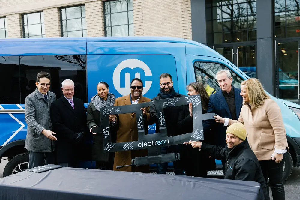
According to a press release issued by Michigan Central, the road will serve as a testing site for this wireless technology before it’s made available to the public. The Michigan Department of Transportation (MDOT) and Electreon, a Newlab at Michigan Central member company, agreed to install a combined mile of inductive-charging roadway in Detroit’s historic Corktown neighborhood. This first completed section of that system runs alongside the Newlab at Michigan Central Building, which is home to more than 60 tech and mobility startups.
“We’re excited to spearhead the development and deployment of America’s first wireless charging road,” said Dr. Stefan Tongur, Electreon Vice President of Business Development. “This milestone stands as a testament to our collaborative efforts with the State of Michigan and MDOT (Michigan Department of Transportation), the City of Detroit, Michigan Central, Ford, Mcity, Jacobs, Next Energy, DTE, and others. Alongside Michigan’s automotive expertise, we’ll demonstrate how wireless charging unlocks widespread EV adoption, addressing limited range, grid limitations, and battery size and costs. This project paves the way for a zero-emission mobility future, where EVs are the norm, not the exception.”
This project was first announced by Michigan Gov. Gretchen Whitmer in September 2021, and Electreon was awarded the contract to develop the test road in February 2022.
“Michigan has always been at the forefront of innovation in mobility, and that forward-thinking is on display with the latest advances in inductive charging from Electreon, the first deployment of this electric vehicle charging technology in the United States,” said Chief Mobility Officer Justine Johnson of the Office of Future Mobility and Electrification. “This latest milestone supports the goals of the MI Future Mobility Plan to grow Michigan’s mobility leadership and proves that companies like Electreon can test and deploy the newest innovations right here in Michigan.”

The EV charging road has inductive coupling between copper coils installed below its surface. EV test vehicles are equipped with receivers that receive electricity wirelessly from this buried system through a magnetic field. The system works when the vehicle is parked (static charging) or when it’s moving down the road (dynamic charging), and is reportedly safe for drivers, pedestrians and wildlife. Each coil in the road is activated only when a vehicle with an approved receiver passes over the coil, ensuring that energy transfer is controlled and provided only to vehicles that require it.
“For more than a century, Detroit has been known around the world as the leader in transportation innovation,” said Detroit Mayor Mike Duggan. “We are the birthplace of the auto industry, and the home of the first mile of concrete road and the first three-way traffic signal. Today, thanks to Gov. Whitmer and our partners at Michigan Central and Electreon, we can add the nation’s first wireless charging public roadway to that list of innovations.”
Throughout early 2024, staff will use a Ford E-Transit electric commercial van provided by Ford Motor Co. and equipped with the Electreon receiver to test the system, the efficiency and operations of the vehicle, and potential long-term public transportation opportunities.
“Developing electrified roadways may be the catalyst to accelerate interest and acceptance of EVs for all consumers,” said MDOT Director Bradley C. Wieferich. “Making it easier for EV users to find a reliable charging source without disrupting their commute supports both fleet operations and passenger travel. We’re proud to collaborate with private industry partners and the City of Detroit to support these important initiatives leading us toward a more sustainable future with fewer emissions.”
MDOT and Electreon have entered a five-year commitment to develop the electric road system (ERS), piloting the technology on Michigan roads. Later this year, MDOT will begin seeking bids to rebuild part of US-12 (Michigan Avenue), a process that will include installing additional inductive charging components. Electreon has also installed two static inductive charging stations in front of Michigan Central Station, which will be able to charge Electreon-equipped vehicles while they are parked.

Keeping EV Projects On Time, On Budget, and Safe
MDOT and Electreon’s pilot program is just the latest example the ongoing effort to develop the nation’s fast-charging infrastructure. Funding continues to flow into the development of EV infrastructure, increasing the number of EV-related construction projects occurring across the country.
On January 11, 2024, the White House announced $623 million in grants to help build out an EV charging network across the U.S., which according to the press release, “will create American jobs and ensure more drivers can charge their electric vehicles where they live, work, and shop.”
“This is a critical part of the Biden Administration’s goal of building out a convenient, affordable, reliable and made-in-America national network of EV chargers, including at least 500,000 publicly available chargers by 2030 ensuring that EVs are made in America with American workers,” the press release stated.
As the country’s EV charging infrastructure continues to evolve and expand, subsurface damage lurks as the likeliest threat to derail these projects and waste federal and/or state dollars on downtime and repair.
A single utility strike can also endanger the lives of workers on site, and the surrounding community. Avoiding strikes keeps people safe and preserves funding which can then be redirected to additional EV infrastructure projects.
GPRS’ damage prevention services help ensure you avoid subsurface damage while excavating for the installation of EV infrastructure. Utilizing ground penetrating radar (GPR) scanners and electromagnetic (EM) locators, our SIM-certified Project Managers (PM) fully visualize the buried infrastructure on your site so you know where you can and can’t safely dig.
GPR is a non-destructive detection and imaging method for seeing inside concrete or underground. A GPR scanner emits radio waves, and then detects the interactions between those waves and any buried objects – both metallic and non-metallic. The interactions are displayed in a readout of hyperbolas that vary in size and shape depending on the type of material located.
Qualified utility locating technicians like GPRS’ PMs can interpret the data collected by GPR scanners and determine the location and depth of the subsurface infrastructure.
Like any technology, GPR has its limits. To compensate for these limitations, GPRS utilizes EM locating in concert with GPR scanning. EM locators detect passive signals emanating from buried electrical lines or active ones transmitted through known utilities, making it the perfect complement to GPR when conducting utility locates.
Avoiding subsurface damage during the installation of EV infrastructure ensures this new infrastructure can sit safely alongside existing utilities, and that the federal and state dollars used to support these projects aren’t wasted on costly repairs.
To ensure the vital subsurface infrastructure you need is at your fingertips throughout the life of your project, GPRS created SiteMap® (patent pending), our cloud-based infrastructure mapping software solution that allows you to safely and securely share your data 24/7, from any computer, tablet, or smartphone.
You receive a complimentary SiteMap® Personal subscription every time you hire GPRS to conduct a utility locate, so that you have instant access to the field-verified data we collect for you.
GPRS’ SiteMap® team members are currently scheduling live SiteMap® demos. Click below to schedule your demo and see how SiteMap® can help you plan, design, manage, dig, and build better today!
Frequently Asked Questions
Are EV charging stations free to use?
There are some free public chargers available, but many chargers require payment with a fee based on how much energy gets transferred to the electric car. The rate can also be based on a per-minute of charging basis, battery size, the charger’s power, or the energy delivery efficiency to the vehicle.
Does GPRS offer same day private utility locating?
Yes, we’ve strategically stationed our team of Project Managers across every major market in the U.S., so we can rapidly respond to your jobsite, no matter where it’s located. Additionally, we are prepared to provide emergency same-day private utility locating services, if needed.
Will I need to mark out the utilities GPRS locates?
No, GPRS will locate and mark all utilities for you. We have a variety of tools and markers we can use to highlight the locations of utilities, underground storage tanks and whatever else may be hiding.
How GPRS' Underground Utility Mapping App, SiteMap®, Helps GCs & FMs Eliminate Reworks
Striking underground utility lines can be deadly.
With over 400 deaths and 2,000 injuries over the last two decades as a direct result of utility line strikes, it doesn’t matter if you’re excavating at your facility for a new building, directional drilling to install a fiber line, or performing a soil boring for an environmental remediation project, you need to be safe when breaking ground. If you break ground without the proper knowledge of current lines underneath your job site it can result in a disastrous situation for you and your team. Not only does it pose significant safety risks that can result in worker injury or death, but striking a buried utility line can also lead to costly project delays of up to six weeks, budget overruns of $56,000 per strike, and damage to a company's reputation that goes beyond a dollar amount.
As technology advances, and number of strikes reported each year continues to grow as reported by the Common Ground Alliance’s 2022 DIRT Report, the importance of safe and efficient ground disturbance practices paired with an accurate utility mapping application such as SiteMap® cannot be overstated.
What Is Underground Utility Mapping & How Does It Work?
Underground utility mapping is a critical component of any excavation, drilling, or soil boring project. It involves accurately locating and digitally mapping the location of underground utility lines on a job site and storing the data within an underground utility mapping application.
For the team at GPRS, during the process of underground utility mapping, multiple forms of technology including ground penetrating radar (GPR), electromagnetic (EM) utility locators, CCTV robotic crawlers with a sonde for certain sewer line inspections, and either a GNSS Geode or GPRS' proprietary GeNiuSS iQ device are used to accurately inspect, map, and collect data points of underground utility locations. This data is then uploaded to the cloud, usually within five minutes of being collected in the field by GPRS Project Managers, and displayed within our new underground utility mapping app, SiteMap®.
Real-Time Data at Your Fingertips
Data collected and securely stored within the SiteMap® mobile app is used to provide a comprehensive record of all the subsurface utilities and above ground infrastructure of the facility or site where the locate was performed within the application’s Map Viewer to help support subsurface damage prevention efforts.
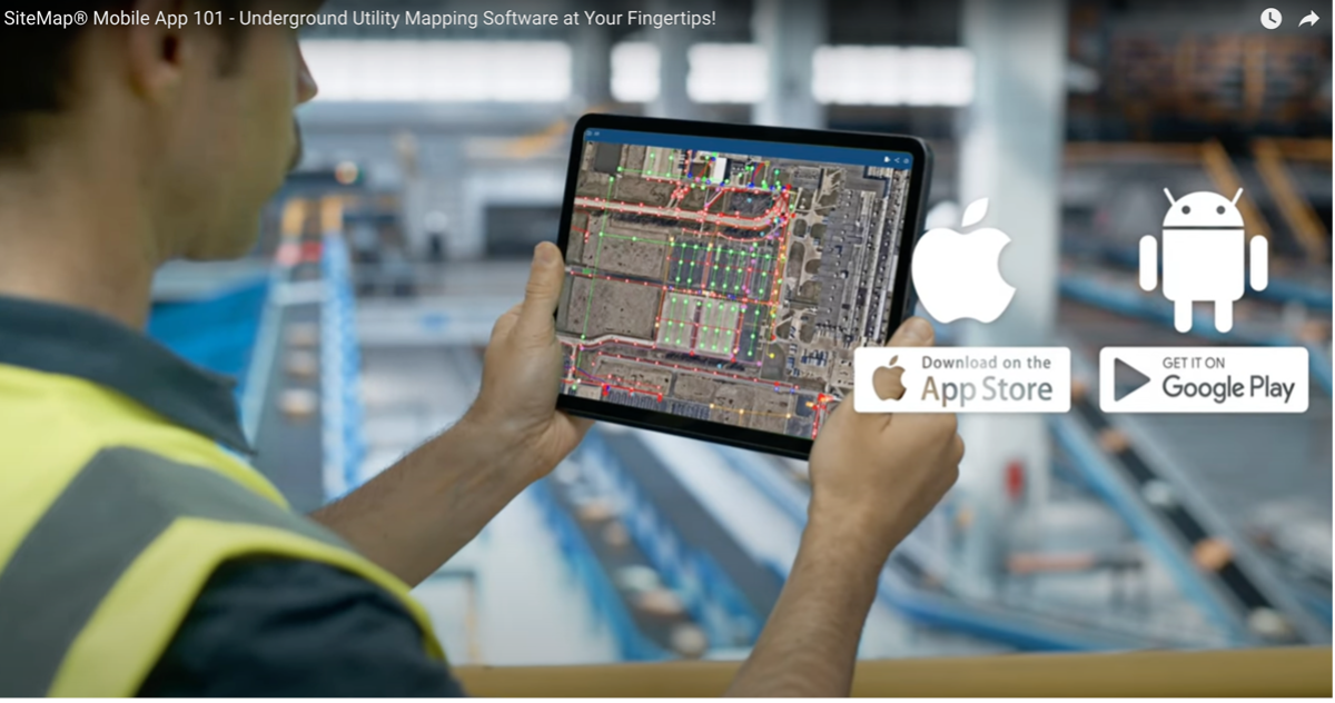
These include but are not limited to, underground utility mapping, NASSCO certified CCTV video pipe inspection sewer line reports, industry leading concrete scan markings collected with 3D Photogrammetry and stored within the platform, as well as underground leak detection data. SiteMap® also houses existing condition documentation data such as accurate 3D BIM Models, 2D CAD drawings, 3D mesh models, digital twins, point clouds, and more, all accurately collected in the field by GPRS Project Managers and beautiful constructed by our in house mapping and modeling team to help ensure your facility and project management goes forward smoothly. This data can be viewed on the go from your tablet or mobile device, eliminating your need to carry around outdated paper plans or reference three or four different GIS systems to try to determine the location of the underground utilities on your job site. This helps ensure that excavation, drilling, and soil boring can move forward safely, and virtually eliminate the reworks or downtime that can occur due to accidentally striking an existing underground line.
With SiteMap's layered utility mapping data, you can experience accurate, detailed, and precise information for every project. SiteMap® provides not only the location of utilities but also approximate depth and size on one an easy-to-use platform, so you can break ground with confidence.

Site Safety Supervisor at Power Construction, Bryant Drechsel, shared how the data and details provided within the SiteMap® App help keep his projects moving forward damage free.
“I got questioned about a communications line that GPRS had scanned for us, and the excavating company was just like, ‘so how deep is this?’ I was able to go into the mobile app of SiteMap®, click on it, and say, ‘Hey it's three to four feet down’… And it was literally at three foot six inches, directly under the line that you guys provided.”
By ensuring accuracy, SiteMap® helps you to mitigate risk and enhance project success every time. The data provided within SiteMap® also enhances communication and effective relationship building between contractors and owners for Bryan and his team at Power Construction.
"What we want to strive for is to keep that owner-contractor relationship strong and by utilizing GPRS we are able to do that because we are confident with the data that [SiteMap®] gives us."
He also shares that utilizing an underground utility mapping app like SiteMap® Mobile helps keep his team aware of what utilities are near their proposed work zone in real time.
"With SiteMap®, being able to upload those things to a mobile app just brings it real time for all the workers on site so they know what they're working for and what they're getting themselves into."
The Precision of SiteMap®

Key Benefits of Using SiteMap® (Powered by GPRS)
• Ease of Use: Navigating SiteMap® is intuitive, making it a seamless addition to your workflow with access to your accurate data only taking a few clicks after upload to the cloud from the field.
• Security: Rest assured, knowing that your utility data is stored securely in the cloud.
• Efficiency: By eliminating reworks due to outdated data, you stay on schedule and reduce unexpected costs.
• Accessibility: Critical utility information is accessible whenever you need it, from any location any time.
• Safety: Keeping workers safe is our #1 priority—SiteMap® greatly reduces the risk of accidental utility strikes on site.
Why SiteMap®?
By harnessing the capabilities of SiteMap® GPRS' Underground Utility Mapping App, you can do more than stay on top of your projects; you're safeguarding your most valuable assets—your people and your reputation. Take advantage of an underground utility mapping app that brings together the ease-of-use, security, and reliability you need to tackle any construction or facility project confidently.
For more information about how SiteMap® can keep your project on budget, on time, and safe, schedule a free demo with one of our SiteMap® experts today.
Frequently Asked Questions
Is utility mapping worth the cost?
Yes. With utility strikes occurring every 62 seconds in the U.S. and being cause for over 400 deaths, and more than 2,000 injuries in the past 20 years, mapping out your underground lines before digging can quite literally be the difference of life and death for you and your team. In the world of construction and facility management, controlling the data that is collected from your job site with utility mapping can not only help control job site damages but also help ensure your team goes home safely to their families at the end of the day.
What’s the difference between SiteMap® and ArcGIS?
It isn't ArcGIS. It won't ever be. While SiteMap® isn’t ArcGIS, it is an application that allows GPRS customers to view, share, and print their infrastructure data, and it’s difference is in the accuracy of the data provided by GPRS Project Managers to our customers. While SiteMap® and ArcGIS are different, data within SiteMap® can be portable to a platform such as ArcGIS, with the potential for data to work together in different applications. Utility mapping in GIS systems such as ArcGIS FieldMaps are used by some underground utility locators and GIS professionals to store their utility data after their locate has been completed. The issue that threatens this GIS utility mapping platform, and others like it, is that the data displayed within is only as accurate as the locate that was performed and uploaded by the technician in the field or provided via as-built data. Our data has the controlled variable of always being collected by GPRS SIM-certified Project Managers, who receive the industries best training, use the industry’s leading and repeatable methodology on every locate performed in the field and utilize multiple forms of cutting-edge technology to provide the 99.8+% accurate data within SiteMap®.
Best Practices for Ethanol Plant Improvements
The Andersons’ Clymer Indiana Ethanol Plant is the largest ethanol plant east of the Mississippi. The facility began operations in April 2007 and has the capacity to produce 110 million gallons of ethanol and 350,000 tons of distillers dried grain annually. Currently, the plant turns corn from more than 600 farms into 5.5 million gallons of ethanol fuel each year. The Clymer’s Ethanol Plant is strategically located next to The Andersons existing grain facility with access to an abundant amount of corn, utilities, and transportation infrastructure.
Process improvement is the proactive task of identifying, analyzing, and improving upon existing business processes, with the goal of improving process efficiency. The company plans to make improvements to the plant over the next five years to improve operational efficiency, lower plant emissions, maintain a quick product turn-around time, and provide outstanding customer service.
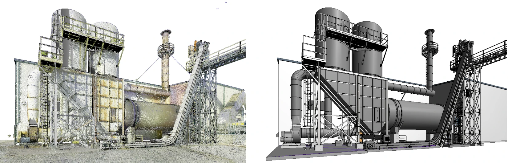
GPRS was hired by TLF Engineers to 3D laser scan the exterior cooler area at the southeast corner of the energy center for process improvements. This 2,500 square foot area includes the existing cooler, drop box, dust collectors, platforms, cooler, stack, and ductwork. Colorized point cloud data was collected of the area and used to create a 3D BIM model at a very high level of detail.
Our client, TLF Engineers, provides professional engineering services to agricultural facilities. They help all types of facilities maintain operations while designing repairs, upgrades, and equipment lines and maintenance for aging structures.
“GPRS 3D laser scanned the site in one day with the Leica RTC360 laser scanner, capturing a full-color point cloud,” said Neville Stringer, GPRS Visualization Consultant. The Leica RTC360 captures two million colorized data points per second with 2–4-millimeter accuracy in less than two minutes and a full-dome HDR image in one minute.
“This means you can complete a full high-resolution scan in less than three minutes per scan location with true HDR imagery,” said Stringer. “The Leica RTC360 laser scanner is a reliable and accurate 3D laser scanner that delivers a high-quality point cloud.”

TLF Engineers’ Senior Project Engineer Seth A.R. Gressley, P.E. stated “We were extremely impressed with GPRS in your timeliness on responding to our request, to having crew on site to complete the scan, and in your communication with us through the process.”
Once data was acquired, it was delivered to the GPRS Mapping & Modeling Team to create a 3D BIM model. Katie Sopko, GPRS Senior CAD Technician said, “We used the point cloud to develop a Revit model of the existing site conditions. I created a 3D BIM model at very high detail of the exposed structure, walls, doors, stairs, roof, railings, ladders, columns, beams, bracing, equipment footprints, foundation, plates, bolt patterns, structural footers, platforms, girders, bollards, HVAC equipment, vents, piping, conduit, ducts, valves, Unistrut, cable tray, and pipe flanges.”
TLF Senior Project Engineer Gressley added, “This was the first time we have used GPRS modeling services, and the 3D model your team created was outstanding. We were very impressed with the level of detail and quality of the model, the speed in which your team was able to create it, and all aspects of communication during the process.”
GPRS also delivered panoramic TruView images of the point cloud to the client. TruViews are 360° photographs taken at each scanner set-up location. A TruView can be used to share point cloud data and mark-ups; take basic dimensions; estimate clearances and distances; and print and convert data. “A TruView gives this client the ability to tour the site through these 360° photographs,” said Sopko.
What is Dry-Mill Ethanol?
Dry-mill ethanol refers to the process of producing ethanol from corn without cooking or liquification. It is the most common method of producing ethanol in the United States. According to the U.S. Department of Energy Alternative Fuels Data Center, the United States is the world's largest producer of corn ethanol, having produced over 15 billion gallons in 2021 and 2022.
Dry-mill ethanol, produced from the dry-milling process of corn, is primarily used as a biofuel additive for gasoline. It is blended with gasoline in varying proportions, such as E10 (10% ethanol and 90% gasoline) or E85 (85% ethanol and 15% gasoline).
Dry-mill ethanol is a renewable alternative to traditional gasoline. It is used to reduce greenhouse gas emissions from transportation and the U.S.’s dependence on fossil fuels. In addition to its use as a fuel additive, ethanol is also used in various industries as a solvent, in the production of beverages and pharmaceuticals, and as a component in personal care products.
Ethanol fuel can be created from corn through a process called ethanol fermentation.
What are the Components of the Exterior Cooler Area that GPRS 3D Laser Scanned?
The Exterior Cooler
The exterior cooler area at the ethanol plant contains heat exchangers, such as air coolers or water coolers, that remove excess heat generated during the fermentation and distillation processes. For example, after the fermentation process, the fermented mash is typically heated to separate the ethanol from the remaining solids. The heat exchangers in the cooler area help to cool down the separated ethanol vapor, condensing it back into a liquid form. The exterior cooler area plays a crucial role in maintaining the optimal operating temperature for different stages of ethanol production, ensuring efficient and safe operation of the plant.
The Dust Collector
The dust collector at an ethanol plant is a system used to capture and remove dust and particulate matter generated during various processes in the plant. Dust collectors are essential for maintaining air quality, preventing the release of harmful particles into the environment, and ensuring the safety of workers.
Dust collectors are commonly used in areas such as grain handling, milling, fermentation, and drying. These areas generate dust and other particulates that need to be controlled to prevent potential hazards and maintain a clean and safe working environment.
Dust collectors typically consist of a blower, filter, and dust collection chamber. The blower creates a suction force that draws dust-laden air into the system, where the dust particles are trapped by the filter. The cleaned air is then released back into the environment, while the collected dust is either disposed of or recycled.
Dust collectors are an important component of ethanol plants, helping to ensure compliance with environmental regulations, protect the health and safety of workers, and maintain efficient plant operations.
The Drop Box
In an ethanol plant, there are two types of drop boxes. In the grain handling section of an ethanol plant, there is a drop box where grains like corn are unloaded from trucks or railcars. This is essentially a large container or bin designed to receive and temporarily store the incoming grain before it is processed further.
In the distillation or dehydration processes, there is a drop box used for collecting the final ethanol product. This is a temporary storage container where the ethanol is collected before being transferred to storage tanks or further processing units.

Ethanol Plant Upgrades to Increase Efficiency and Lower Emissions
TLF Engineers will seek to optimize the following processes to help The Andersons' Clymers facility improve their overall efficiency, decrease air pollution, reduce costs, and remain competitive in the market.
By optimizing processes and equipment, the ethanol plant can improve their operational efficiency and lower plant emissions.
- Optimize the milling process to improve ethanol yield and quality
- Optimize the production processes: the milling, fermentation, distillation, and dehydration processes to improve ethanol production efficiency
- Optimize dust collection and filtration systems to reduce air pollution
- Upgrade equipment to improve reliability and efficiency
TLF Engineers stated, “We have a desire to be involved with this unique work and have developed comfort and skill in working in industrial facilities safely and efficiently.”
As for GPRS 3D Laser Scanning Services, “We greatly appreciated all the help and will continue using your services in the future,” added TLF’s Gressley.
Does Ethanol Production Create Air Pollution?
An ethanol plant could contribute to air pollution through various processes and emissions. Some potential sources of air pollution from an ethanol plant include:
- Particulate Matter: Dust and particulate matter can be generated during grain handling, milling, and drying processes. If not properly controlled, these particles can be released into the air, contributing to air pollution.
- Volatile Organic Compounds (VOCs): VOCs can be emitted during the fermentation and distillation processes. VOCs are a type of air pollutant that can react with other compounds in the atmosphere to form smog.
- Carbon Monoxide (CO): CO can be produced during the combustion of fossil fuels for heat and power in the plant. CO is a poisonous gas that can be harmful to human health and the environment.
- Nitrogen Oxides (NOx): NOx emissions can be generated during combustion processes, such as in boilers or engines used for power generation. NOx is a precursor to smog and can contribute to respiratory issues and environmental damage.
- Greenhouse Gas Emissions: While ethanol itself is considered a renewable fuel with lower greenhouse gas emissions compared to gasoline, the production process can still contribute to greenhouse gas emissions. Emissions can occur during the production and transportation of feedstocks, as well as during the energy-intensive processes within the ethanol plant.
To mitigate these potential sources of air pollution, ethanol plants can implement various control measures, such as using dust collection systems, optimizing combustion processes to minimize emissions, and using cleaner energy sources. Additionally, regulatory agencies often impose emission limits and require monitoring and reporting to ensure compliance with air quality standards.
The facilities aim to reduce these toxic chemicals, as exposure to high amounts can cause symptoms like headaches, drowsiness, burning in the nose, throat and eyes, coughing, nausea, vomiting, and trouble breathing.
In an effort to keep the public informed about toxic chemicals and pollution in their communities, the EPA created a program for companies to report the use of toxic chemicals called Toxics Release Inventory Program.
What are the Benefits of Ethanol?
Ethanol produced from corn grain is a renewable, domestically produced transportation fuel. Because of its high oxygen content, ethanol burns more completely than ordinary unleaded gasoline and reduces harmful tailpipe emissions. Ethanol also has a higher-octane number than gasoline, which provides increased power and performance. For example, IndyCar drivers often fuel their race cars with E98 because of its high octane.
Experts at the Department of Energy’s Argonne National Laboratory published a study demonstrating that average corn ethanol reduces Greenhouse Gas emissions by 44 to 52 percent compared to gasoline.
In December 2021, the Biden Administration issued an Executive Order calling for most federal vehicle acquisitions to be zero-emission vehicles by 2035. The Biden Administration and the U.S. Department of Agriculture (USDA) have recently announced incentives and funding for biofuel development and infrastructure.
“Ethanol already cuts carbon emissions in half compared to gasoline; with smart policy measures, ethanol can do even more,” said RFA President and CEO Geoff Cooper. “Ethanol can serve as a zero-emissions fuel for cars and trucks while also helping to decarbonize the aviation, marine, and stationary power generation sectors.”
More About The Andersons’ Clymers Indiana Ethanol Plant
The Andersons’ Clymers Ethanol Plant is a producer and supplier of ethanol, natural gasoline, corn oil, liquified CO2, as well as blending systems.
The facility is located in a high producing corn growing region in Indiana. The facility features 4 million bushels of on-site corn storage, unit train rail loading and unloading facilities, Norfolk Southern mainline access, and existing grain processing infrastructure. The facility is well located to provide ethanol to east coast and southeastern markets, as well as to supply Chicago, Indianapolis, and Gary, Indiana via truck.
Neill McKinstray, Vice President & General Manager, Ethanol Division for The Andersons said, “The Andersons’ Clymers Indiana Ethanol Plant provides an additional market for area corn growers, many of whom have an established relationship with The Andersons, and a local supply of distillers dried grains for area animal farmers.”
The Andersons, Inc. is a diversified company with interests in the grain, ethanol, and plant nutrient sectors of U.S. agriculture, as well as in railcar leasing and repair, turf products production, and general merchandise retailing. Founded in Maumee, Ohio, in 1947, the company now has operations in seven U.S. states plus rail leasing interests in Canada and Mexico.

Why GPRS? The GPRS Difference.
The professionals at GPRS have extensive experience 3D laser scanning for the agricultural industry, including grain handling, storage, feed, milling and processing industries. We have 3D laser scanned grain facilities, ethanol facilities, production agriculture, grain processing operations and suppliers to the food corn industry.
From the initial planning and design of a grain silo, to engineering grain intake and distribution towers, to construction of a grain loading dock, to replacing ducts and piping for a grain chute, to analyzing tank farm slab elevation contours – and everything in between – GPRS has the resources to create a solution unique to your business needs.
We have completed scanning projects ranging from small rooms to entire facilities. We have captured precise data of grain intake and distribution towers, tanks, silos, hoppers, conveyors, support cables, structural members, machinery, equipment, rail spurs, catwalks, cleaning houses, grain elevators, drive throughs, and so much more.
GPRS utilizes Leica Geosystems 3D laser scanners to provide a safe and accurate means of collecting site and overhead data from the ground, providing vital detail for design planning and analysis.
What can we help you visualize?
Frequently Asked Questions
Is there any government support for biofuel production facilities?
U.S. Department of Agriculture (USDA) announced that the Department has provided $700 million to help lower costs and support biofuel producers who faced unexpected market losses due to the COVID-19 pandemic. The funds are being made available through the Biofuel Producer Program, which was created as part of the Coronavirus Aid, Relief, and Economic Security Act (CARES Act). The investments include more than $486 million for 62 producers located in socially vulnerable communities. The Program will support agricultural producers that rely on biofuels producers as a market for their agricultural products. By making payments to producers of biofuels, the funding will help maintain a viable and significant market for such agricultural products.
How much does 3D laser scanning cost?
The cost of 3D laser scanning can vary widely depending on your project scope. GPRS customizes every quote specific to your project’s needs. GPRS Project Managers use 3D laser scanners to capture every detail of your site, delivering building dimensions, locations, and layout with 2-4 millimeter accuracy. This can include the aboveground structural, architectural, and MEP features, plus underground utility and concrete markings. Our Mapping & Modeling Team can deliver point clouds, 2D CAD drawings, 3D BIM models, 3D Mesh models, TruViews, and Virtual Tours at any level of detail.
How are 3D BIM models used for clash detection?
A 3D BIM model helps clients evaluate if the new elements fit accurately within the existing structure and enable clash detection to identify conflicts between the design and as-built conditions. With a 3D BIM model, clients can virtually see what conflicts or overlaps in the project design plans. They can inspect each new component, pipe, or system within the as-built conditions and discover clashes.
Construction Industry Overview: Construction Job Market Still Hot?
In November of 2023, South Carolina-based Global Location Strategies CEO, Didi Caldwell, told Construction Dive that then-current manufacturing construction was “a once-in-a-lifetime or once-in-a-century-type event that we’re experiencing.” The article went on to list industries that were all racing to feed the appetites of the auto, smartphone, electronics, EVs, and even various military and security applications for technology that had long been imported from other countries.

What is “Onshoring” and How Does it Impact the Construction Industry?
Onshoring refers to operations and work previously outsourced to countries outside the U.S. being brought back to America. The most prevalent example of onshoring in current news comes from the microchip and semiconductor industries, spurred by the Infrastructure Investment and Jobs Act, the CHIPS Act, and the Inflation Reduction Act. All of that industry coming into the United States has to be housed somewhere, which has led to what some have called the biggest boon to U.S. manufacturing construction since 1979.
It’s been nearly six months since publication after publication breathlessly touted the construction boom in their headlines, GPRS included. So, we wanted to check back in to see if general contractors, manufacturers, AEC professionals, and trades were still booming, or eyeing a bust on the horizon.
Where We Were
In February of 2024, the U.S. Census Bureau clocked December 2023 construction spending at a seasonally adjusted 14% increase over December 2022. “The year over year gains [in 2023] were nearly universal across project types,” according to Associated General Contractors of America’s (AGC) Chief Economist, Ken Simonson.
Simonson also touted a “more impressive 20 percent” gain in non-residential construction spending in the same period with every Census Bureau-reported construction spending area experiencing an increase of between 1% and 61%.
That 61% increase in non-residential construction was in manufacturing construction, with $81 billion in gains over 2022. $68 billion of that gain was attributed to “computer/electronic/electrical manufacturing,” which would include onshoring and expansions like recent projects we’ve reported on in Ohio and Kentucky, among others.
The Census Bureau figures bear out continued new investment and construction across various manufacturing sectors in 2023 which are ongoing into 2024, including a big bump in the power construction sector, which includes renewables, of some 24%.
The investment in power of all types is important, as data center construction was booming as we entered 2024, causing traditional data corridors in places like Virginia to look to innovate as their energy needs soar.
Where We Are
Even with lending rates still surpassing 10% or more for non-residential construction, the construction industry is still racing to fill unclaimed jobs across the board. The most recent Labor Department figures reported on April 5, 2024 showed that 39,000 new construction industry jobs added to the surprisingly strong jobs report.
As reported by NPR’s Scott Horsley, Associated Builders and Contractors’ (ABC) chief economist Anirban Basu called it “a blockbuster jobs report,” and noted that the new report highlighted the fact that construction doubled its hiring gains average over the last 12 months, adding, “recession is not arriving anytime soon.”
Perrysburg, Ohio’s Kwest Group was also tapped by NPR, and their CEO, Ryan Odendahl, said they are looking to hire more people right now and that, “Young people are starting to see the opportunity, both from an earnings potential and a growth potential that the construction industry offers.”
In fact, ABC’s Construction Confidence Index reports that 48% of builders anticipate additional new hires over the next six months – traditionally construction’s “busy season” across the U.S. – with only 11% expecting to shrink their workforce over the same period.

Those figures are in line with the construction unemployment rate, which still sits higher than the 3.4% national average, at 5.4%. However, that number is down from 5.6% in 2023.
It is important to note that a wide swath of the northern U.S. enjoyed far warmer than normal temperatures for most of the early months of 2024, which means more projects could proceed without stopping for harsh outdoor conditions, as well.
The weather, along with onshoring and the unprecedented federal manufacturing spending boost have led many companies to step up their recruitment and hiring efforts. Some 501,000 new construction sector jobs, over and above the pace of “normal” hiring, will need to be filled to complete most 2024 projects, according to ABC.
Further, according to Builder Online, AGC’s 2024 outlook reporting shows that, “[M]ore than two-thirds of respondents [to their annual survey] expect to add to their headcount in 2024… “Additionally, nearly one-quarter of respondents anticipate headcount for their firm increasing by more than 10% in 2024.”
More than 75% of those same respondents also said they’re struggling to fill open positions, and expect it to become more difficult to find salaried or skilled tradespeople throughout 2024.
This is leading firms to look at increasing base pay, add to their portion of paid benefits, and provide additional incentives and bonuses to secure the workforce they need. Nearly every area of construction is impacted: heavy equipment operators, masons, carpenters, plumbers, and electricians are all in demand.

Where We’re Headed: Embrace the Boom, but Tread Carefully
If construction workers can command top dollar, and relatively high interest rates are not slowing manufacturing construction in the near-term, that means something has got to give.
Many industry watchers are predicting a slowdown in project completion caused by workforce issues. And, while some industry economists are looking at a mixed overall bag for growth in 2024, there is no denying that non-residential construction is moving full speed ahead as we get into Q2.
Specific to large design-build projects, developers, and general contractors, one of the cement industry’s top economists, Ed Sullivan, said the PCA’s (Portland Cement Association) forecast expects the market to “weaken” over the first half of 2024 and recover as the construction season moves ahead. And Electrical Contractor calls the marketplace “Strong but challenged,” but also admits that this economy is unprecedented, exemplifying many industry-watchers desire to embrace the boom, but tread carefully.
GPRS helps customers Intelligently Visualize The Built World® and provides existing conditions documentation, damage prevention, and site and facility data management solutions to the construction and related industries.
What can we help you visualize?
Frequently Asked Questions
How does GPRS help general contractors and construction supervisors increase productivity?
GPRS provides accurate as-built documentation – above and below-ground – for the construction and related industries nationwide. We can capture existing conditions with 2-4mm accuracy for aboveground features and provide 99.8%+ accurate utility mapping. All of our data capture, maps, and models are delivered to customers via SiteMap®, our damage prevention and facility management application that allows you to securely share information with your team, on site or off, 24/7. Every GPRS customer receives a complimentary SiteMap® subscription – learn more here.
What specific visualization services does GPRS provide?
GPRS provides 99.8% accurate utility locating and concrete scanning and imaging services, 3D laser scanning with 2-4mm accuracy, NASSCO-certified video pipe (CCTV sewer scope) inspections, leak detection, and can build customized 2D and 3D drawings, maps, models, and reports to meet your specific project needs. We are the only company in the U.S. with the ability to provide full site visualization on a national scale, with 500 elite Project Managers stationed throughout the country, so there’s always a professional utility locator, concrete scanner, laser scanner, leak detector, and sewer inspection company near you.
How do I get a job with GPRS?
At GPRS, we don’t want to give you a job, we want to provide you with a career. That’s why our Project Managers undergo extensive training in Subsurface Investigation Methodology; so that they can arrive on any jobsite anywhere in the country (and sometimes outside it) and provide professional visualization and damage prevention services to keep construction jobs on time, on budget, and safe. Learn more about a career with GPRS, here.
Beneath the Surface with SiteMap®: Navigating Underground Utility Mapping Software
The average depth of the ocean floor bed is just over 12,000 feet. The deepest part of the ocean is called the Challenger Deep, and it’s estimated to run 35,867 feet deep. The world below our feet is vast, from the ocean to the soil beneath your favorite geraniums. One of the greatest challenges lies beneath the surface – navigating the complex network of underground utilities. Accidental damage to buried pipes, cables, or conduits can result in costly delays, safety hazards, and environmental concerns. To mitigate these risks, industry professionals rely on advanced technologies such as digital utility mapping software. Among these solutions, SiteMap® (patent pending), powered by GPRS, stands out as a comprehensive tool for interactive underground utility mapping.
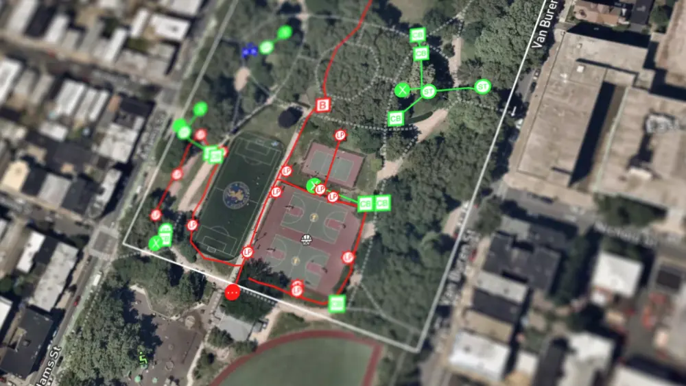
Understanding Digital Utility Mapping
Digital utility mapping entails generating comprehensive maps and databases that illustrate the position, type, and attributes of underground utilities. This data is essential for the planning, designing, constructing, and maintaining of projects. Conventional utility mapping techniques, like manual surveys or paper-based documentation, can be laborious, imprecise, and error-prone. By employing advanced technologies such as Geographic Information Systems (GIS), Global Positioning Systems (GPS), and Ground Penetrating Radar (GPR), digital utility mapping offers accurate and current insights into subsurface infrastructure.
The History of Modern Underground Utility Mapping
The history of underground utility mapping can be traced back to the early 20th century when urbanization and industrialization spurred the need for more comprehensive infrastructure networks. Initially, utility mapping primarily relied on manual methods such as hand-drawn maps, paper records, and physical surveys to document the location of underground assets. However, these methods were labor-intensive, prone to errors, and lacked the ability to provide real-time updates. The advent of technologies such as Ground Penetrating Radar (GPR), electromagnetic induction, and Geographic Information Systems (GIS) in the latter half of the 20th century revolutionized utility mapping by enabling more accurate and efficient data collection and analysis.
These advancements paved the way for the development of digital utility mapping solutions, which utilize sophisticated sensors, GPS technology, and computer software to create detailed maps and databases of underground infrastructure. Today, underground utility mapping has become an integral part of construction, engineering, and urban planning projects, playing a vital role in ensuring the safety, efficiency, and sustainability of our built environment.
The process, as we know it today, can be accurate enough to support SUE (subsurface utility engineering) at level QL-B. While GPRS doesn’t offer SUE, how we use our technology can support surveyors in some ways.
The Development of SUE
Subsurface Utility Engineering (SUE) developed in the early 1980s as a solution to the shortcomings of conventional methods in managing subsurface utilities. Traditionally, projects were planned without comprehensive knowledge of underground utilities, leading to complications such as avoidable relocations, delays, and unforeseen encounters during construction. Engineers recognized the necessity for a more anticipatory approach and began integrating nascent technologies—specifically air/vacuum excavation and surface geophysics—to accurately identify subsurface utilities at the early stages of project planning.
Air/vacuum excavation was adopted as a safer substitute for traditional trenching, especially in highway construction where the danger of damaging utilities posed considerable safety risks. By revealing subsurface utilities before digging commenced, the likelihood of accidents, injuries, and property damage markedly decreased. This method quickly gained traction among progressive professionals in the highway sector.
Alongside, surface geophysics was introduced as an essential adjunct to overcome the limitations of vacuum excavation alone. Early SUE advocates, recognizing the challenges posed by relying solely on potentially inaccurate or incomplete utility records, stressed the importance of employing sophisticated surface geophysical tools to precisely locate subsurface utilities horizontally. Through the use of cutting-edge geophysical technologies, SUE innovators sought to deliver accurate and dependable data, thus enhancing decision-making in infrastructure development projects.
The Late 1980s
In the late 1980s, the significance of Subsurface Utility Engineering (SUE) began to resonate with highway engineers, marking a pivotal moment in its adoption. The Virginia Department of Transportation emerged as a trailblazer, becoming the first state agency to integrate SUE into its regular operations. Subsequently, its implementation spread to neighboring states such as Maryland, Delaware, and Pennsylvania, signifying a growing recognition of its benefits across the transportation sector.
Additional facets of SUE emerged, including surveying subsurface information, data management, and integration with clients' Computer-Aided Design and Drafting (CADD) systems or project plans. This expanded scope underscored the importance of SUE as a comprehensive service offering, encompassing not only utility identification but also data management and project coordination.
Furthermore, the late 1980s saw significant developments in the professionalization of SUE practices. Key initiatives included the sealing of deliverables and the procurement of professional liability insurance, which positioned SUE as a recognized professional service rather than merely a contractor service. These measures aimed to uphold industry standards, enhance accountability, and mitigate potential risks associated with utility-related projects.
In 1989, a pivotal moment occurred at the First Annual National Highway Utility Conference in Cleveland, where the term "Subsurface Utility Engineering" was introduced to a national audience as an umbrella term for the process formerly known as "Designating and Locating." This designation quickly gained traction and was abbreviated to "SUE," cementing its place as a foundational practice in infrastructure development and utility management.
Brief Breakdown
- 1982–SUE developed
- 1985 – First statewide SUE contract with Virginia Department of Transportation
- 1986 – First statewide UC contract with Virginia Department of Transportation
- 1991 – FHWA began promoting SUE
- 2002 – Standard ASCE 38-02 was adopted by American Society of Civil Engineers
- 2018 – 38+ State DOTs using Statewide\DistrictWide\Region-Wide UES Services
- 2022 – Anticipated the release of Standard ASCE 38-22
Understanding SiteMap®
SiteMap® is a cutting-edge utility mapping app developed to streamline the process of underground utility management. Designed for professionals in the construction, engineering, and utility sectors, SiteMap® offers a range of features and functionalities tailored to meet the diverse needs of users.
Key Features of SiteMap®
Interactive Mapping Interface
SiteMap® provides users with an intuitive and user-friendly interface for visualizing underground utilities with ease. The interactive map allows users to zoom in, pan, and overlay different layers of utility data, providing a comprehensive view of the subsurface environment. Whether it's water lines, sewer pipes, gas mains, or electrical cables, SiteMap® helps users identify and analyze underground assets with ease.
Data Integration and Collaboration
SiteMap® allows seamless data portability with existing GIS databases, CAD drawings, and utility records, ensuring compatibility and data interoperability. Depending on your subscription level, users may have the ability to upload, edit, and share utility information in a centralized platform, facilitating collaboration and communication among project stakeholders. With SiteMap®, teams can access the latest updates and revisions from their favorite device, reducing the risk of conflicts or discrepancies during construction activities.
Mobile Accessibility
SiteMap® is available as a mobile application, allowing users to access utility maps and data directly from the field. In fact, SiteMap® was designed with mobile in mind. Equipped with advanced technology, the app enables users to understand their location and navigate underground infrastructure with precision. Field personnel can view annotated maps, read observations, and view photographs on-site, enhancing data accuracy and efficiency. SiteMap® empowers users to make informed decisions and respond quickly to changes or emergencies, regardless of their location.
Benefits of SiteMap®
Improved Safety
By providing accurate and up-to-date information about underground utilities, SiteMap® helps mitigate the risk of accidental damage or excavation-related incidents. Users can identify potential hazards, such as buried gas lines or high-voltage cables, and take appropriate precautions to ensure safety on the job site. With SiteMap®, safety becomes a top priority, protecting workers, assets, and the surrounding environment. This safety is supported by GPRS’ 99.8% accuracy rating, providing accurate data across more than 500,000 jobs nationwide.
Cost Savings
SiteMap® minimizes costly errors and rework associated with utility conflicts, clashes, or relocations during construction projects. By optimizing excavation activities and avoiding utility strikes, users can reduce downtime, delays, and repair expenses. The ability to plan and coordinate utility work more efficiently translates into significant cost savings over the lifecycle of a project. SiteMap® helps maximize productivity and profitability, enabling projects to stay on schedule and within budget.
Regulatory Compliance
SiteMap® facilitates compliance with regulatory requirements and industry standards for underground utility management. Users can use SiteMap® to help generate reports, documentation, and as-built drawings to demonstrate adherence to safety regulations and permit conditions. SiteMap® also supports efforts in asset inventory tracking, maintenance scheduling, and historical record-keeping, ensuring accountability and transparency throughout the project lifecycle.
SiteMap® represents a change in the way we navigate and manage underground utilities. SiteMap® offers an advanced, easy-to-use solution for interactive underground utility mapping, enabling users to visualize, analyze, and manage subsurface infrastructure with unprecedented accuracy and efficiency. Whether it's planning a construction project, conducting maintenance activities, or responding to emergencies, SiteMap® empowers professionals to make informed decisions and achieve optimal outcomes. With SiteMap®, the path beneath the surface becomes clearer, safer, and more manageable.
GPRS’ SiteMap® team members are currently scheduling live, personal SiteMap® demos. Click below to schedule yours today!
Mitigating the Risks of Leaks in Fire Suppression Systems
Fire suppression systems are a critical component of building safety, providing a first line of defense against the outbreak of fire.
Like any system, however, these systems are not immune to wear and tear. Leaks can occur over time.
Leaks in fire suppression systems can lead to reduced effectiveness in the event of a fire, increased maintenance costs, and the risk of water damage to property. Regular inspections of these systems by professional leak detection specialists can keep them working properly, ensuring they’re ready in the event of an emergency.

Regular Inspections
Regular inspections are the cornerstone of maintaining the integrity of fire suppression systems. According to Control Fire Systems, a leading provider of fire protection equipment, a comprehensive inspection should include a visual examination of all system components, a check for signs of corrosion or damage, and a test of the system's functionality. During these inspections, professionals can identify potential issues before they escalate into major problems. It is recommended that inspections be carried out at least annually, with more frequent checks in environments that are prone to corrosion or where the system is subject to heavy usage.
Acoustic Leak Detection
One of the most effective methods for detecting leaks in fire suppression systems is acoustic leak detection. This technology works by identifying the sound of escaping water or gas within the system's pipes. Acoustic leak detection devices are highly sensitive and can pinpoint the location of a leak with remarkable accuracy. This method is non-invasive, meaning that it can be carried out without disrupting the normal operation of the system. By implementing acoustic leak detection, facility managers can detect leaks early, reducing the risk of system failure and minimizing water damage.
Leak Detection Correlators
Leak detection correlators are another advanced tool for identifying leaks in fire suppression systems. These devices work by analyzing the sound of a leak collected by sensors placed at various points along the system's piping. By comparing the time it takes for the sound to reach each sensor, the correlator can accurately determine the location of the leak. This technology is particularly useful for locating leaks in large or complex systems where traditional methods may be less effective. By using leak detection correlators, maintenance teams can quickly identify and repair leaks, ensuring the system remains in optimal condition.
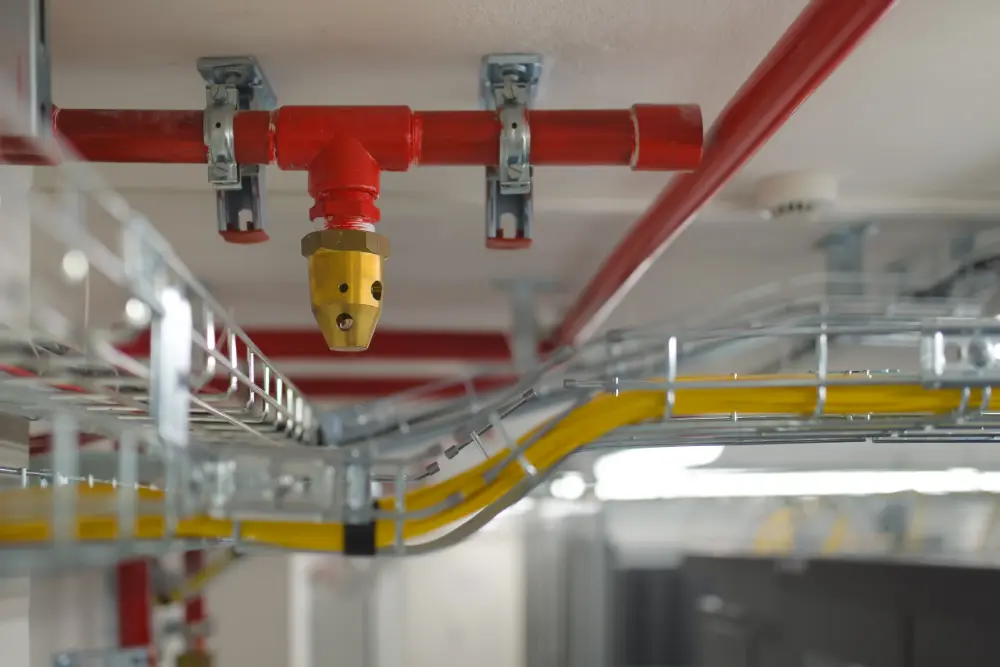
Non-Revenue Water Loss
Leaks in fire suppression systems can also contribute to non-revenue water loss, which is water that is lost before it reaches the consumer due to leaks, theft, or metering inaccuracies. In the context of fire suppression, non-revenue water loss can result in increased operational costs and reduced system efficiency. By implementing effective leak detection and repair strategies, organizations can minimize non-revenue water loss, leading to cost savings and improved system reliability.
Best Practices for Leak Mitigation
In addition to regular inspections from companies specializing in the use of advanced leak detection technologies, there are several best practices that can help mitigate the risks of leaks in fire suppression systems:
- Proper Installation: Ensuring that the system is installed correctly by qualified professionals is critical in preventing leaks.
- Corrosion Protection: Implementing measures to protect against corrosion, such as using corrosion-resistant materials and applying protective coatings, can extend the lifespan of the system and reduce the likelihood of leaks.
- Pressure Monitoring: Regularly monitoring the system's pressure can help identify fluctuations that may indicate a leak.
- Training and Awareness: Educating staff about the importance of leak detection and encouraging them to report any signs of leaks can aid in early detection and repair.
- Emergency Response Plan: Having a plan in place for responding to leaks can minimize damage and ensure a swift return to normal operations.
- Valve Exercising: When water system valves stiffen, they can impact flow and pressure with corrosion, rust, and mineral deposits. If left in a static position too long, stiffened valves can become inoperable or incompletely shut off. Exercising your valves regularly can avoid stiffening and the issues it can cause. GPRS can provide valve exercising services to keep every part of your pressurized water system intact.
Leaks in fire suppression systems pose a significant risk to building safety and operational efficiency.

How GPRS Leak Detection Services Protect Fire Suppression Systems
By hiring a professional leak detection company that utilizes advanced leak detection technologies such as acoustic leak detection and leak detection correlators, and adhering to best practices, organizations can effectively mitigate these risks. Not only does this ensure the reliability of the fire suppression system, but it also contributes to cost savings and the prevention of non-revenue water loss.
GPRS Project Managers specialize in all types of leak detection, including the inspection of fire suppression systems. Using commercial acoustic leak detectors in combination with leak detection correlators, we eliminate the need for exploratory digging to find leaks, saving you money and time and causing minimal surface disruption.
From skyscrapers to sewer lines, GPRS Intelligently Visualizes The Built World® to keep your projects on time, on budget, and safe.
What can we help you visualize? Click below to schedule a service or request a quote today!
Frequently Asked Questions
Why does GPRS typically inspect water systems in the early hours of the morning, or late at night?
Our acoustic listening equipment is highly sensitive and amplifies leaks and other noises which mask leak signals during the day. If we work in urban environments, there is often a significant amount of ambient noise. This noise includes airplanes, traffic, mowers, machinery, and most importantly, people using water. It is up to the Project Manager to determine if night work should be utilized to minimize all other noise to focus on the leak signal.
Can you tell me how big the leak is that you’ve detected?
We determine the size of the leak based on how far the leak signal travels between contact points and the pitch of the tone received. We do not, however, produce formal leak estimations.
Why don’t I see any water at the location you’ve pinpointed as the leak?
Water finds the path of least resistance. Water can run through cracks in subsurface rock or make its way into storm, sanitary, and conduit piping. If the subsurface contains a high volume of sand, it will naturally flow farther down. There is no water visible on the surface in more than 99% of the leaks we locate.
Factors Affecting GPR Accuracy
Ground Penetrating Radar (GPR) is a non-invasive geophysical method used for subsurface imaging. It's widely employed in various fields such as geology, archaeology, environmental studies, and civil engineering, particularly for utility locating and precision concrete scanning and imaging.
The accuracy of GPR is influenced by several factors, which are crucial to understand for anyone involved in subsurface exploration, including professional utility locators and concrete scanning technicians.

These factors include:
Soil and Material Composition – The type of soil or material through which the GPR signal travels significantly affects its accuracy. Different materials have varying electrical properties, which can either attenuate or reflect the radar waves. For instance, sandy soils with low moisture content are ideal for GPR as they allow deeper penetration, whereas clay soils with high moisture content can absorb the radar waves, limiting their penetration depth.
Moisture Content – Water content in the soil is another critical factor. High moisture levels can increase the conductivity of the soil, leading to a quicker attenuation (reduction of the force/effect) of the radar waves. This is why GPR surveys are often more successful in dry conditions.
Frequency of the Radar – GPR systems use antennae with different frequencies, typically ranging from 10 MHz to 2.6 GHz. Lower frequency antennae can penetrate deeper but provide lower resolution images, while higher frequency antennae offer higher resolution images but have a shallower penetration depth. Selecting the appropriate frequency based on the specific application is crucial for achieving accurate results.
Depth and Size of the Target – The depth and size of the target also play a significant role in the accuracy of GPR. Shallower and larger targets are easier to detect and provide clearer images, while deeper and smaller targets might be more challenging to identify due to signal attenuation and dispersion.
Surface Conditions – The condition of the ground surface can affect the quality of GPR data. Smooth and flat surfaces are ideal for GPR surveys, as they allow for consistent contact between the antenna and the ground. In contrast, rough or uneven surfaces can cause signal scattering and loss, leading to less accurate results.
Electromagnetic Interference – GPR accuracy can be compromised by electromagnetic interference from nearby power lines, radio transmitters, or other electronic devices. Such interference can distort the radar signal, making it difficult to interpret the data accurately.
Data Processing and Interpretation – The accuracy of GPR is not only dependent on the data collection process but also on the subsequent data processing and interpretation. Advanced processing techniques can enhance the signal-to-noise ratio and improve image clarity. Additionally, experienced professionals are better equipped to interpret the data accurately, identifying subsurface features and distinguishing between different materials.
Operator Experience – The skill and experience of the operator conducting the GPR survey can significantly impact the accuracy of the results. Experienced operators are more adept at selecting the appropriate settings, conducting the survey efficiently, and interpreting the data accurately.
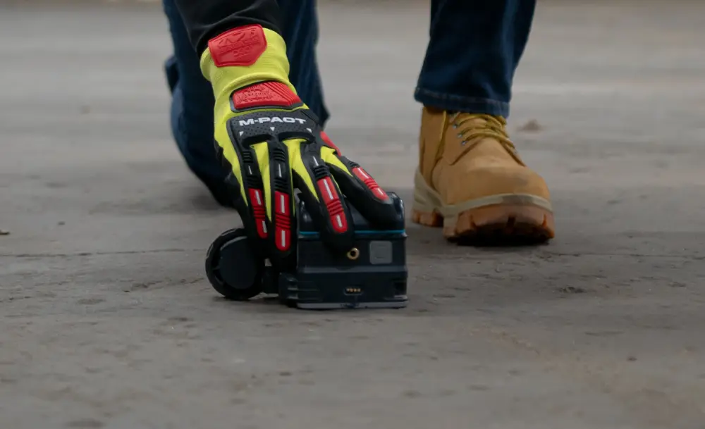
Understanding and managing the factors that affect the accuracy of GPR is crucial for anyone involved in subsurface exploration. By carefully considering these factors, it's possible to maximize the accuracy and reliability of GPR scanning, ensuring that the technology provides valuable and actionable information for a wide range of applications.
GPRS Project Managers (PMs) are experts at utilizing not only GPR, but other technologies such as electromagnetic (EM) locating to help you Intelligently Visualize The Built World®.
We have achieved and maintained a 99.8%+ rate of accuracy on the over 500,000 utility locating and concrete scanning projects we’ve completed to date, in large part thanks to our adherence to Subsurface Investigation Methodology, or SIM.
Through this program, GPRS PMs complete 320 hours of field training and 80 hours of classroom training. The classroom education occurs at GPRS’ state-of-the-art training facility in Sylvania, Ohio, where the PMs-in-training tackle real-world scenarios in a safe and structured environment that allows them to create consultative solutions to unique problems.
While it’s possible to purchase or rent GPR and/or EM locators to attempt to locate and map your utilities or scan your concrete slabs yourself, the cost to buy or rent this equipment and train yourself or a member of your team – not to mention the risks involved in missing something buried where you plan to dig – make hiring a professional utility locating/concrete scanning company the right call.
From skyscrapers to sewer lines, GPRS Intelligently Visualizes The Built World® to keep your projects on time, on budget, and safe.
What can we help you visualize? Click below to schedule a service or request a quote today!
Frequently Asked Questions
Can GPR equipment be used on vertical surfaces or ceilings?
We regularly use GPR equipment to scan for the location of rebar in concrete columns and walls. GPR can also examine the underside of a floor to mark out the reinforcing steel and any embedded conduits.
Can GPR determine the exact size of a subsurface void cavity?
No. GPR equipment can identify the area where a void is potentially occurring and the boundaries of that potential void. It cannot measure the void’s depth.
Is GPR safe to use?
Yes, unlike concrete X-ray, GPR is a safe, non-invasive tool that does not emit any harmful radiation or other byproducts. The scanning process does not create any noise, and the area can remain undisturbed during the scan.
The Indirect Costs of Construction-Related Injuries: A Hidden Burden in Construction
Construction is widely recognized as one of the most hazardous industries, with a high incidence of workplace accidents and injuries.
According to the National Safety Council (NSC), the construction industry continues to experience the highest number of preventable fatal work injuries year-over-year compared to other industries. There were 957 construction-related fatalities in 2020, 946 in 2021, and 1,018 in 2022.
While the direct costs of construction-related injuries, such as medical expenses and workers' compensation, are often readily quantifiable, the indirect costs can be more elusive and, in many cases, significantly greater.
Understanding and addressing these indirect costs is crucial for the construction industry, not only from a financial perspective but also for enhancing worker safety and organizational efficiency.

The Tip of the Iceberg: Direct Costs
Direct costs are the immediate financial expenditures associated with construction-related injuries, including medical treatment, rehabilitation, and compensation for lost wages. These expenses are often covered by insurance, making them more visible and easier to quantify. However, they represent just the tip of the iceberg when it comes to the total cost of workplace accidents.
The Hidden Costs: Indirect Expenses
Indirect costs, on the other hand, are less obvious and more challenging to quantify. They encompass a wide range of financial impacts that are not directly related to medical expenses or compensation but are nonetheless a consequence of workplace accidents. These costs can include:
- Lost Productivity: When a worker is injured, their absence can lead to delays in project timelines, reduced efficiency, and the need for overtime work by other employees to compensate for the shortfall.
- Training and Replacement: Hiring and training new or temporary workers to fill in for injured employees can be a costly and time-consuming process.
- Equipment Damage: Accidents often involve damage to machinery or equipment, leading to repair or replacement costs and additional potential downtime.
- Administrative Burden: Managing the aftermath of an accident involves significant administrative work, including accident investigations, paperwork for insurance claims, and compliance with regulatory requirements.
- Impact on Morale: Workplace accidents can have a profound effect on the morale and mental well-being of employees, leading to decreased productivity and increased absenteeism.
- Reputation Damage: Frequent accidents can tarnish a company's reputation, potentially leading to lost business opportunities and difficulty in attracting skilled workers.
- Legal Costs: In some cases, accidents may result in legal action, leading to additional expenses for legal representation and potential settlements.
Estimating the True Cost
The indirect costs of construction-related injuries are often estimated to be several times higher than the direct costs. However, the exact ratio can vary depending on the nature and severity of the accidents, as well as the specific circumstances of the construction project.
According to the Workplace Safety and Insurance Board, the average cost of one lost-time construction injury on a job site is $35,000 – although many injuries cost much more due to litigation, medical expenses and compensation. Additionally, 6-9% of construction project costs are workplace injury related, leading to long-term increases in insurance costs and shrunken profit margins.

Mitigating the Indirect Costs
Addressing the indirect costs of construction-related injuries requires a comprehensive approach that goes beyond simply adhering to safety regulations. Some strategies for mitigating these costs include:
- Investing in Safety Training: Regular and thorough safety training for all employees can help prevent accidents and reduce the severity of injuries when they do occur.
- Implementing Safety Technologies: Advances in technology, such as wearables that monitor worker fatigue and alert systems for hazardous conditions, can enhance safety on construction sites.
- Fostering a Safety Culture: Creating a workplace culture that prioritizes safety can encourage employees to take proactive measures to prevent accidents and report potential hazards.
- Engaging Early Return-to-Work Programs: Implementing programs that facilitate the early return of injured workers to light-duty or modified roles can help reduce the duration of lost productivity.
- Performing Regular Equipment Maintenance: Ensuring that all equipment and machinery are regularly maintained and in good working order can prevent accidents caused by malfunctions.
The indirect costs of construction-related injuries represent a significant financial burden on the industry, often exceeding the direct costs by a wide margin. By understanding and addressing these hidden costs, construction companies can not only improve their bottom line but also enhance the safety and well-being of their workforce. Investing in safety training, technology, and a culture of safety is not just a moral imperative but a sound business strategy that can lead to long-term success and sustainability in the construction industry.
GPRS’ Commitment to Construction Safety
At GPRS, safety is our top priority. To that end, we sponsor a series of construction safety-related initiatives designed to educate you and your team on the best practices to ensure everyone leaves the job site in the same condition they arrived to it.
During these initiatives, GPRS safety experts travel across the country meeting you and your team where they are to deliver vital safety information.
Concrete Sawing & Drilling Safety Week focuses on the dangers of cutting and coring concrete, and the best practices to mitigate these risks. From proper PPE use to avoiding kickback while cutting or coring concrete, you and your team will learn how to keep yourselves and each other safe.
Construction Safety Week takes a broader look at jobsite safety, as we advocate for improved safety processes, mental health resources, and equipment standards that can reduce the risk of injury and create a safer environment for workers.
Water & Sewer Damage Awareness Week sees us shift our focus to the buried water and wastewater pipes that service our homes and businesses. During this week, you’ll learn about the risks your systems face every day, and how routine water loss surveys, and proactive water, sewer, and stormwater system maintenance plans eliminate service interruptions and maintain your entity’s reputation.
Click here to learn more about GPRS’ commitment to safety.
Revolutionizing Infrastructure Efficiency in Japan: The ROADIC System and SiteMap® Integration
Japan is recognized worldwide as a leader in pioneering technologies and creative methods for enhancing urban areas.
The Japanese government invests more than $2.3 billion annually into universities and scientific research, solidifying its reputation as an innovative powerhouse. A prime example of this innovation is the ROADIC System (Road Information Management System), an elaborate platform devised by Japanese authorities to improve the efficiency, safety, and sustainability of the nation's transportation infrastructure. Although ROADIC is well-established in Japan, it remains relatively unknown globally due to its ever-evolving technologies, which mirror the dynamic nature of Japan itself.
SiteMap® (patent pending), powered by GPRS, serves as a top-tier infrastructure mapping solution, operating in a manner akin to the ROADIC System but tailored for private sector use. Both technologies signify a significant advancement in infrastructure management, utilizing cutting-edge 3D mapping and underground facility management to achieve unparalleled levels of efficiency, effectiveness, and reductions in rework throughout the global infrastructure network.

The ROADIC System: Redefining Infrastructure Management in Japan
The ROADIC System serves as a comprehensive platform for managing Japan's extensive network of roads, bridges, tunnels, and underground utilities. Developed by the Japanese Ministry of Land, Infrastructure, Transport and Tourism (MLIT), the system provides centralized access to a wealth of infrastructure data, including road conditions, maintenance schedules, traffic flow, and underground utilities. By consolidating disparate datasets into a unified platform, the ROADIC System empowers government agencies, infrastructure operators, and urban planners with actionable insights and analytics to optimize infrastructure planning, maintenance, and development initiatives.
The History of ROADIC
The Road Administration Information Center (ROADIC) was created in 1986 as a result of several large-scale gas explosions that killed and injured hundreds of Japanese people, while causing tremendous damage. The gas line explosions and the need to coordinate road construction, coupled with available funding at the ministry level, lent significant impetus to the formation of ROADIC. The Japanese national government saw the need to develop an approach to preserve public safety and to improve response to accidents involving this significantly expanding public energy source. It took the lead to organize ROADIC through its Ministry of Construction, Bureau of Roads, which proactively enabled the foundation of the program in 1986.
As a collection of public and private members, ROADIC was set up as a national project in order to manage and protect the public utilities within the right-of-way. Following a successful initial implementation in metropolitan Tokyo in the mid-1980s, additional branches have been integrated within 12 major urban centers throughout Japan. Some of these cities include: Tokyo (23 separate Wards), Sapporo, Chiba, Kawasaki, Yokohama, Nagoya, Kyoto, Osaka, Kobe, Hiroshima, Kitakyushu and Fukuoka. These 12 branches coordinate with local government agencies and public utility companies including electric, gas, water, sewer, trains, subways and communications.
The original cost of establishing the ROADIC program was in the range of ¥ 9.5 billion, or $8.7 million U.S. 60% of this cost was funded by the national government. The remainder was contributed by interested local governments and utility companies. In 2003, the annual operating budget was ¥ 3.4 billion, or approximately $3.1 million U.S. The Japanese national government provides 50% of the annual operating funds. Both taxpayers and ratepayers are supporting ROADIC operations.
ROADIC Study Missions
In the early 1990s, the Geospatial Information & Technology Association, previously known as AM/FM International, established its Japanese branch. This initiation sparked ROADIC's interest in the newly formed affiliate’s activities. Many of ROADIC's founding members played a crucial role in setting up and expanding GITA-Japan. Additionally, a broad spectrum of geospatial professionals from Japanese utilities, government bodies, and private companies started participating in GITA's annual conferences held in the United States.
Over time, ROADIC leveraged these conferences, using the technical educational programs as platforms to pinpoint particular applications of geospatial technology that were relevant to their current interests. This involvement evolved into organizing “study missions” to North American and European utilities, cities, government agencies, and private companies, establishing a routine of alternating visits between the two continents every other year. These exchanges allowed host countries and Japanese professionals to freely share and enhance geospatial infrastructure management solutions, fostering ongoing global enhancements.
These missions typically take place in October and have been annual events since 1990, except for a hiatus in 2001 due to the 9/11 terrorist attacks. The ROADIC delegation usually comprises 12-18 representatives from Japanese utilities, government agencies, and private sector firms. They prepare a comprehensive list of questions for each site visit. On-site, a Japanese translator ensures all critical details about each project or implementation are clearly understood, facilitating the group. Individual perspectives and observations are gathered, and a comprehensive report of each visit is compiled. Upon returning to Japan, the insights are further analyzed and integrated into the ROADIC system, incorporating any particularly valuable ideas from the visits.
This distinctive approach to on-site learning has led to continual improvements within the system. Such initiatives have established the ROADIC system as a premier example of multi-organizational collaboration and knowledge exchange on a global scale.
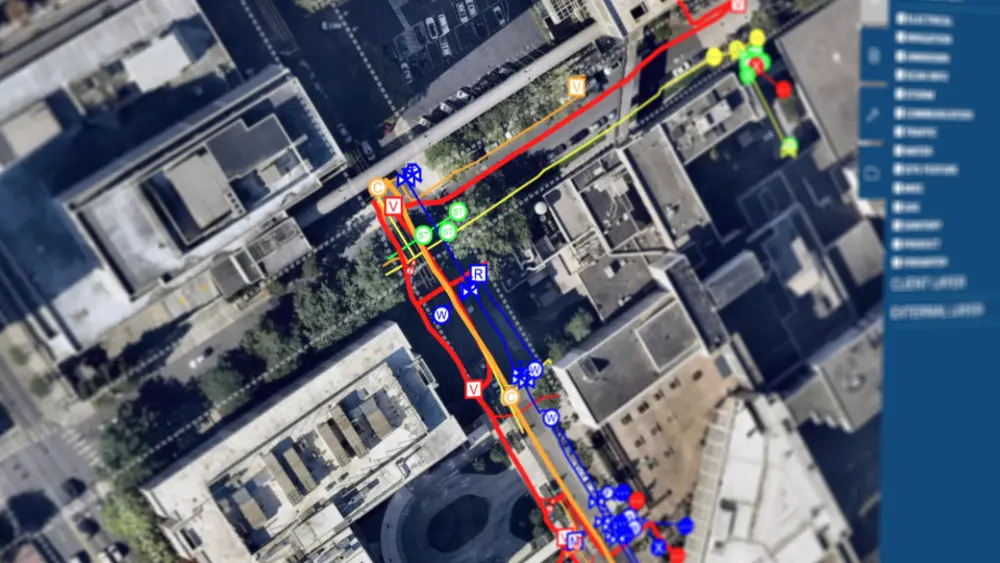
SiteMap®: Unlocking the Power of 3D Infrastructure Mapping and Underground Facility Management
At the heart of the ROADIC System's capabilities lies technology that is also used by GPRS, and therefore, SiteMap®, a state-of-the-art infrastructure mapping solution renowned for its advanced 3D mapping and underground facility management functionalities. Similarly, should they wish to, by incorporating SiteMap® into the ROADIC System, Japanese authorities could gain access to a suite of powerful tools and features that may enhance the system's effectiveness and efficiency:
Comprehensive Infrastructure Mapping
SiteMap® enables the creation and delivery of detailed existing conditions and 3D maps of an infrastructure network, providing stakeholders with a comprehensive view of roadways, bridges, tunnels, and underground utilities. This detailed mapping data serves as a foundation for informed decision-making, allowing authorities to identify potential bottlenecks, optimize traffic flow, and prioritize infrastructure investments.
Advanced Visualization Capabilities
SiteMap®'s advanced visualization capabilities empower users to interactively explore and analyze infrastructure data in a virtual environment. By visualizing complex infrastructure networks in 3D, stakeholders can gain insights into spatial relationships, identify potential conflicts, and assess the impact of proposed projects on existing infrastructure assets.
Efficient Underground Facility Management
Managing underground utilities is a critical aspect of infrastructure maintenance and development, particularly in densely populated urban areas. SiteMap®'s underground facility management capabilities enable municipal managers and authorities to accurately map, monitor, and maintain underground utilities, minimizing the risk of damage during construction activities and improving overall infrastructure resilience.
Data Integration and Collaboration
SiteMap®’s data portability allows it to work well with existing infrastructure methods and systems, enabling interoperability and data sharing across different government agencies and stakeholders. This supportive approach streamlines workflows, enhances collaboration, and fosters data-driven decision-making, leading to more efficient and effective infrastructure management practices. While SiteMap® offers its own GIS platform, it's easy to utilize with other platforms as well.
SiteMap® allows customers to visualize their underground infrastructure in much the same way as Japan’s data system, with accurate as-built data.
When you hire GPRS, your subsurface utilities are located, mapped, and layered in our interactive geospatial platform that allows you to deconstruct your utility map, as well. And because it’s cloud-based, SiteMap® is secure, accessible 24/7, and shareable with those you designate for as long as they need the information.
Extra Savings
Because GPRS services support SUE QL-B, you could achieve significant savings by greatly reducing potholing, utility strikes, and the cost overruns usually associated with construction, expansion, or infrastructure installation by having 24/7 access to GPRS 99.8%+ accurate subsurface information via SiteMap®.
The continued cost savings of digitizing and aggregating your underground utility maps has not been studied in significant numbers, but a recent case study cited in the Common Ground Alliance’s 2022 DIRT Report showed that the city of Chicago reduced its underground utility strikes by 50% over a five-year period by creating accessible aggregated utility maps in a GIS platform.
So, by utilizing SUE Standard A or B to locate and accurately map subsurface utility and infrastructure data, general contractors, facility managers, stakeholders, and municipalities could slash project costs by 9% - 40%.
Similar Cases
SiteMap® creates an accurate single source of truth for your entire team. Backed by the amazing 99.8% accurate data provided by GPRS, SiteMap® functions as a one stop shop for everything subsurface. Much like ROADIC, SiteMap® utilizes the finest technology to accurately and simply map the world below your feet. Other nation’s have accomplished similar efforts:
Sarajevo, Bosnia
Over 40 years ago, Sarajevo mandated the recording of the location of all utility and telecommunications infrastructure data in the city. This was originally done manually on paper maps, much like in other countries. However, several years ago Sarajevo began converting these maps to digital format which run on Oracle Spatial.
Calgary, Alberta
Many years ago the city passed a by-law which mandated that all utilities and telecoms working within city limits must provide data showing the geolocation of their infrastructure. This data would have to be reported to the city's Joint Utility Mapping Project (JUMP). JUMP provides a single-source database which shows the geolocation of all underground utilities.
São Paulo, Brazil
The City of Sao Paulo's GeoCONVIAS project integrates data from 20 to 30 utilities which operate in the city of Sao Paulo.
Rio de Janeiro, Brazil
The City of Rio de Janeiro has a similar project GeoVias funded by the government of the City of Rio de Janeiro and four utilities, as well as a project to monitor offshore seismic activity.
The ROADIC System marks a significant milestone in Japan's continuous drive to improve the efficiency, safety, and sustainability of its infrastructure network.
Despite the adoption of 811 services in the USA, SiteMap® emerges as a frontrunner in subsurface mapping, paralleling the ROADIC System. Utilizing sophisticated 3D mapping and underground facility management technologies, the ROADIC System provides authorities with groundbreaking insights and analytics that enhance infrastructure planning, upkeep, and expansion efforts. Similarly, SiteMap® employs the same pioneering methods and technologies that have made ROADIC a celebrated model, revolutionizing how we understand and manage subsurface environments, one city at a time.
GPRS SiteMap® team members are currently scheduling live, personal SiteMap® demos so you can see how this infrastructure mapping software solution can help you plan, design, manage, dig, and build better.
Click below to sign up for your demo today!
Michigan Public Service Commission Approves Enbridge's Line 5 Relocation Project
In a landmark decision, the Michigan Public Service Commission (MPSC) has granted approval for Enbridge Energy to relocate a segment of its Line 5 oil and natural gas pipeline.
The existing pipeline, which currently rests on the lakebed of the Straits of Mackinac, will be moved into a newly constructed service tunnel beneath the straits. This move is poised to significantly enhance the environmental safety and operational reliability of the pipeline, which is a critical component of the region's energy infrastructure.
Background of Line 5
Line 5 is a 645-mile pipeline that transports up to 540,000 barrels per day of light crude oil, light synthetic crude, and natural gas liquids. The pipeline, which has been in operation since 1953, is a vital artery for the transportation of energy resources across the Great Lakes region, supplying refineries in Michigan, Ohio, Pennsylvania, Ontario, and Quebec.
The Controversy Surrounding Line 5
The pipeline's location at the bottom of the Straits of Mackinac, a narrow waterway connecting Lake Michigan and Lake Huron, has been a source of environmental concern for years. Critics argue that a potential spill could have catastrophic consequences for the Great Lakes, which contain about 20% of the world's fresh surface water. The aging infrastructure of Line 5 and the risk of anchor strikes from passing ships have heightened these concerns.
The Tunnel Solution
Enbridge's proposal to construct a tunnel beneath the Straits of Mackinac is aimed at addressing these environmental and safety concerns. The tunnel, which is estimated to cost $500 million, would encase a new segment of the pipeline, protecting it from external impacts and reducing the risk of a spill. The MPSC's approval of the site permit is a critical step forward in realizing this project.
The Approval Process
The approval process for the tunnel project has been rigorous, involving multiple regulatory bodies and extensive public consultation. The MPSC's decision comes after careful consideration of the environmental, economic, and technical aspects of the project. The commission has set forth several conditions for the construction and operation of the tunnel to ensure compliance with environmental and safety standards.
Implications of the Decision
The MPSC's approval of the tunnel project is a significant development for both Enbridge and the communities that rely on Line 5 for their energy needs. For Enbridge, the decision provides a clear path forward to modernize and secure a critical piece of infrastructure. For the region, the relocation of Line 5 into a tunnel beneath the straits promises enhanced environmental protection and energy security.
Environmental and Economic Benefits
The tunnel project is expected to bring several environmental and economic benefits. By reducing the risk of a spill, the project will help protect the Great Lakes and the surrounding ecosystems. The construction of the tunnel is also anticipated to create jobs and stimulate economic activity in the region.
Ongoing Challenges and Opposition
Despite the MPSC's approval, the tunnel project faces ongoing challenges and opposition. Some environmental groups and Indigenous communities have raised concerns about the continued operation of Line 5 and the potential impacts of the tunnel construction on the environment. Legal challenges and regulatory hurdles may still lie ahead for Enbridge as it seeks to bring the project to fruition.
The Road Ahead
With the MPSC's approval in hand, Enbridge can move forward with the detailed planning and construction of the tunnel. The company has stated that it aims to complete the project by 2024, pending further regulatory approvals and the resolution of legal challenges. The successful completion of the tunnel will mark a significant milestone in ensuring the safe and reliable operation of Line 5 for years to come.
The Michigan Public Service Commission's approval of the site permit for Enbridge's Line 5 tunnel project is a pivotal moment in the ongoing debate over the pipeline's future. By relocating a segment of Line 5 into a service tunnel beneath the Straits of Mackinac, Enbridge aims to address environmental and safety concerns while ensuring the continued flow of vital energy resources. The decision represents a balance between protecting the Great Lakes and meeting the region's energy needs, but it also underscores the complex challenges and competing interests that must be navigated in the pursuit of energy infrastructure development.
As the project moves forward, it will be closely watched by stakeholders on all sides of the issue.
On Track for Progress: The Impact of Rail Service on Regional Development
The introduction or expansion of passenger rail services can have a transformative effect on various aspects of local development.
Columbus Business First recently reported on announced federal funding for the creation of development plans for four total Amtrak service corridors in and around Ohio:
- Cleveland-Columbus-Cincinnati-Dayton
- Chicago-Fort Wayne-Columbus-Pittsburgh
- Cleveland-Toledo-Detroit
- Increased service frequency on Amtrak’s current route to Cincinnati between New York City, Washington, D.C., and Chicago via the states of Virginia, West Virginia, Kentucky, Indiana, and Illinois
Experience Columbus CEO Brian Ross told Columbus Business First that although the project is still in the planning stage and Columbus is not guaranteed to receive a route, “This will help people get to and from Columbus and Central Ohio, and help with residents moving here because of the easy access to those cities.”

From enhancing workforce mobility to boosting tourism and supporting broader mobility plans, rail networks offer a multitude of benefits that contribute to the economic and social growth of an area. In this article, we'll explore how rail service can improve a region's workforce, tourism industry, mobility plans, and more.
Empowering the Workforce
One of the most significant impacts of rail service is its ability to improve workforce mobility. By providing a reliable and efficient mode of transportation, rail networks enable employees to commute more easily, accessing a wider range of job opportunities. This not only benefits individuals by expanding their employment options but also helps employers by broadening the pool of potential workers. Moreover, reduced commuting times and the convenience of rail travel can lead to increased job satisfaction and productivity, further enhancing the region's economic performance.
Boosting Tourism
Rail service can also play a crucial role in boosting a region's tourism industry. Tourists are often attracted to areas that are easily accessible by public transportation. Rail networks can connect key tourist destinations, making it more convenient for visitors to explore different attractions without the hassle of driving or finding parking. Additionally, scenic train routes can become attractions drawing visitors who are looking for unique travel experiences. The increased tourist footfall can lead to higher spending in local businesses, such as hotels, restaurants, and shops, further stimulating the regional economy.
Supporting Mobility Plans
Incorporating rail service into a region's mobility plans is essential for creating a more sustainable and integrated transportation system. Rail networks can serve as the backbone of public transportation, connecting with other modes such as buses, trams, and bike-sharing schemes. This multimodal approach can reduce reliance on private vehicles, leading to decreased traffic congestion and lower emissions. Furthermore, rail infrastructure can be designed to accommodate future growth, ensuring that the region's transportation system remains resilient and adaptable to changing needs.
Enhancing Accessibility and Social Equity
Rail service can enhance accessibility and promote social equity by providing affordable and convenient transportation options for all residents, including those without access to a car. This is particularly important for low-income individuals, seniors, and people with disabilities, who may rely more heavily on public transportation. By improving access to essential services, employment, and educational opportunities, rail networks can help bridge the mobility gap and contribute to a more inclusive society.
Encouraging Economic Development
The development of rail infrastructure can attract businesses and stimulate economic growth in a region. Companies often look for locations with good transportation links when deciding where to set up operations. Rail service can make a region more attractive to potential investors, leading to job creation and increased economic activity. Additionally, the construction and maintenance of rail infrastructure provide employment opportunities and can drive demand for local goods and services.
Reducing Environmental Impact
Rail service is one of the most environmentally friendly modes of transportation. Trains emit significantly lower levels of greenhouse gases per passenger mile compared to cars and airplanes. By encouraging more people to use rail instead of private vehicles, regions can reduce their carbon footprint and contribute to global efforts to combat climate change. Furthermore, rail networks can be powered by renewable energy sources, further enhancing their sustainability.
Improving Quality of Life
The benefits of rail service extend beyond economic and environmental factors to include improvements in the overall quality of life for residents. Reduced traffic congestion and lower pollution levels contribute to cleaner air and a healthier environment. The convenience and reliability of rail travel can reduce stress associated with commuting, providing more time for leisure and family activities. Additionally, the development of rail infrastructure can lead to the revitalization of neighborhoods and the creation of vibrant, pedestrian-friendly communities.
Challenges and Considerations
While the benefits of rail service are clear, there are also challenges to consider. The initial investment in rail infrastructure can be substantial, and securing funding can be a complex process. There may also be opposition from residents or businesses concerned about noise, disruption, or changes to the local landscape. Careful planning and community engagement are essential to address these concerns and ensure that the rail network meets the needs of the region.
The introduction or expansion of rail service can have a profound impact on a region's development, offering a wide range of benefits from improving workforce mobility to enhancing quality of life. By providing an efficient, sustainable, and inclusive mode of transportation, rail networks can support economic growth, boost tourism, and contribute to a healthier environment. While challenges exist, the potential rewards make rail service an invaluable asset for any region looking to build a brighter future.

GPRS Services Support Rail Expansion
From passenger rail service expansion in Columbus, to parking garages in New York City, infrastructure projects require careful planning and preparation to ensure their success.
This starts with understanding what infrastructure is buried beneath the project site before any shovels hit the ground.
GPRS’ utility locating and mapping services support infrastructure expansion by providing you with 99.8%+ accurate data of all buried lines and other subsurface obstructions that could otherwise derail your project.
From skyscrapers to sewer lines, we Intelligently Visualize The Built World® to keep your projects on time, on budget, and safe.
What can we help you visualize? Click below to schedule a service or request a quote today!
Frequently Asked Questions
What type of informational output is provided when GPRS conducts a private utility locate?
Our Project Managers (PMs) flag and paint our findings directly on the surface. This method of communication is the most accurate form of marking when excavation is expected to commence within a few days of service.
GPRS also uses a global positioning system (GPS) to collect data points of findings. We use this data to generate a plan, KMZ file, satellite overlay, or CAD file to permanently preserve results for future use. GPRS does not provide land surveying services. If you need land surveying services, please contact a professional land surveyor.
Does GPRS offer same-day private utility locating?
Yes, our professional Project Managers (PMs) can respond rapidly to emergency same-day private utility locating service calls on your job site.
Will I need to mark out the utilities that GPRS locates?
No, GPRS will locate and mark all utilities for you. We have a variety of tools and markers we can use to highlight the locations of utilities, underground storage tanks and whatever else may be hiding.
Microtrenching vs. Directional Drilling: A Comparative Analysis of Utility Installation Methods
Microtrenching and directional drilling are minimally destructive alternatives to traditional trenching when installing underground utilities.
Both methods offer unique advantages and challenges, making them suitable for different scenarios.

Microtrenching: A Quick and Cost-Effective Solution
Microtrenching involves cutting a narrow and shallow trench, typically 1-2 inches wide and 12-24 inches deep, along the side of roads or sidewalks. The utility cables or conduits are then laid in the trench, which is subsequently filled with a protective material and sealed.
Advantages of Microtrenching
Speed: Microtrenching is known for its rapid deployment. The process is significantly faster than traditional trenching methods, allowing for quicker project completion.
Cost-Effectiveness: Due to its speed and the minimal amount of excavation required, microtrenching is often more cost-effective than other installation methods.
Reduced Disruption: The narrow trenches and surface-level work cause less disruption to traffic and surrounding infrastructure compared to traditional trenching, making it an ideal choice for urban environments.
Limitations of Microtrenching
Durability Concerns: The shallow depth of the trenches may expose cables to potential damage from surface activities or environmental factors.
Limited Applications: Microtrenching is primarily suitable for fiber optic cables and may not be appropriate for larger utilities or in areas with heavy vehicular traffic.
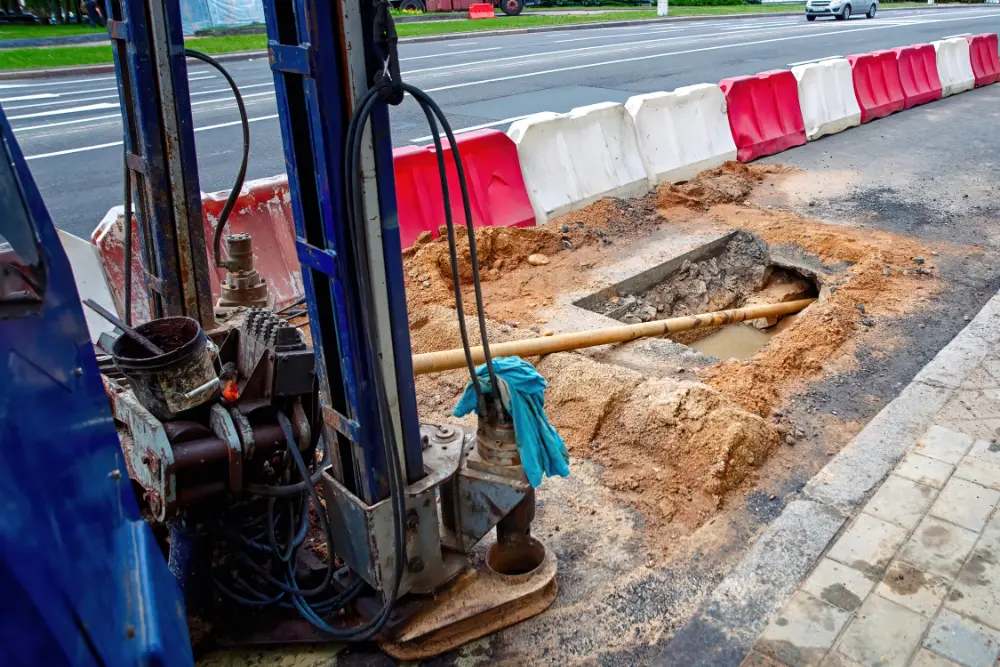
Directional Drilling: Navigating Obstacles with Precision
Directional drilling, also known as horizontal directional drilling (HDD) or directional boring, is a trenchless method that involves drilling a pilot hole along a predetermined path, followed by enlarging the hole to accommodate the utility conduit, which is then pulled through the opening.
Advantages of Directional Drilling
Obstacle Avoidance: HDD can navigate around underground obstacles, making it suitable for crossing water bodies, roads, and other barriers without disrupting the surface.
Environmental Protection: As a trenchless method, directional drilling minimizes environmental impact, preserving the ecosystem and reducing the need for restoration.
Versatility: HDD can be used for a wide range of utilities, including water, gas, and telecommunications lines, and is effective in various soil types and conditions.
Limitations of Directional Drilling
Cost: Directional drilling can be more expensive than microtrenching, particularly for short distances, due to the specialized equipment and expertise required.
Site Access: The setup for HDD requires a larger footprint, which may be challenging in congested urban areas.
Complexity: The planning and execution of directional drilling projects are more complex, requiring precise calculations and skilled operators.
Cross Bores: A directional drill bit pierces through a sewer pipe as easily as it does rock, so the operator can’t tell the difference between the two. If proper precautions aren’t taken, it’s very easy to accidentally bore a new line through an existing utility, creating a dangerous phenomenon known as a cross bore.
Comparative Analysis
When comparing microtrenching and directional drilling, several factors come into play:
Application Scope: Microtrenching is best suited for installing fiber optic cables in urban settings, while directional drilling is more versatile, accommodating a variety of utilities and environments.
Cost Considerations: Microtrenching generally offers cost savings for short distances in accessible areas, whereas directional drilling, despite its higher initial cost, provides value in complex installations and longer runs.
Environmental Impact: Both methods are less invasive than traditional trenching, but directional drilling has the edge in minimizing surface disruption and protecting natural habitats.
Installation Speed: Microtrenching is faster and more straightforward, making it ideal for rapid deployments. Directional drilling, while slower, offers precision and the ability to navigate obstacles.
In the realm of utility installation, both microtrenching and directional drilling have their place, each with distinct advantages and limitations. The choice between the two methods depends on factors such as the type of utility being installed, the project's scale and complexity, the geographical and environmental context, and budget constraints. By understanding the nuances of these techniques, utility providers and contractors can make informed decisions that ensure efficient, cost-effective, and environmentally responsible installations.
GPRS Can Help Mitigate Risk During Utility Installation
Whether microtrenching or directional drilling, it’s important you know what’s below before breaking ground for any utility installation.
GPRS’ utility locating and video pipe inspection services mitigate the risk of subsurface damage during utility installation projects by ensuring you have a comprehensive understanding of the buried infrastructure on your job site.
Using ground penetrating radar (GPR) and electromagnetic (EM) locating, our SIM-certified Project Managers (PMs) can visualize all buried utilities, underground storage tanks (USTs) and other unseen impediments that would otherwise lead to costly and potentially dangerous damage.
Our state-of-the-art, remote-controlled sewer pipe inspection rovers can be deployed both before and after utility installs occur to mitigate the risk of cross bores: inadvertent intersections of buried utilities that are most often caused by trenchless technology such as directional drilling. Cross bores can compromise the safety of buried infrastructure, leading to groundwater contamination, service interruptions, or even explosions when gas and sewer lines are involved. So, it’s vital that we prevent the creation of these dangerous defects and identify and repair any that already existing within our infrastructure.
From skyscrapers to sewer lines, GPRS Intelligently Visualizes The Built World® to keep your projects on time, on budget, and safe.
What can we help you visualize? Click below to schedule a service or request a quote today!
Frequently Asked Questions
What type of informational output is provided when GPRS conducts a utility locate?
Our Project Managers (PMs) flag and paint our findings directly on the surface we’re investigating. This is the most accurate form of marking and communication when excavation is expected to commence within a few days of service.
We also use a global positioning system (GPS) to collect data points of findings. We use this data to generate a plan, KMZ file, satellite overlay, or CAD file to permanently preserve results for future use.
Finally, all our findings are instantly uploaded into SiteMap® (patent pending), our cloud-based infrastructure mapping software solution where you can securely access your data 24/7, from any computer, tablet, or smartphone.
Every GPRS customer receives a complimentary SiteMap® Personal subscription with every utility locate.
Will I need to mark out the utilities GPRS locates?
No, GPRS will locate and mark all utilities for you. We have a variety of tools and markers we can use to highlight the locations of utilities, underground storage tanks and whatever else may be hiding.
What size pipes can GPRS inspect?
Our elite, NASSCO-certified Project Managers (PMs) can inspect pipes from 2” in diameter and up.
What deliverables does GPRS offer when conducting a VPI?
GPRS is proud to offer WinCan reporting to our video pipe inspection clients. Maintaining sewers starts with understanding sewer condition, and WinCan allows GPRS Project Managers to collect detailed, NASSCO-compliant inspection data. And we not only inspect the interior condition of pipes, laterals, and manholes – we also provide a map of their location. The GPRS Mapping & Modeling Department can provide detailed GPS overlays and CAD files. Our detailed WinCan/NASSCO reports contain screenshots of the interior condition of the pipe segments that we inspect, as well as a video file for further evaluation, documentation, and/or reference.
GPR Services Aid in Safe Excavation of 24-Mile Pipeline
Ground penetrating radar services provided by GPRS aided in the safe excavation of a 24-mile-long pipeline in Monument, New Mexico.
GPRS Area Manager Ryan Dennis was called in to scan along 13 miles of the pipeline’s known path and verify the location and depths of multiple types of utility lines, including communication, irrigation, water, sewer, power, and natural gas.
GPRS primarily uses ground penetrating radar (GPR) when conducting utility locating services. GPR is a non-destructive detection and imaging method which identifies subsurface elements either underground or within a surface such as concrete.

GPR works by sending a radio signal into a structure and reading the interaction between the radio waves and subsurface objects they encounter, including both metallic and non-metallic materials. These interactions – sometimes referred to as “bounces” – are detected by the GPR unit and displayed in a readout of hyperbolas varying in size and shape depending on what type of material was located.
Properly trained utility locating professionals such as GPRS’ SIM-certified Project Managers (PMs) and Area Managers (AMs) can interpret the data in these readouts to determine what type of utilities or other obstructions were located and provide the estimated depth of these items.
When used properly, GPR scanning is a highly accurate method for conducting utility locates and/or precision concrete scanning and imaging. But while GPRS derives its name from GPR, we have become much more than just a GPR company. When locating utilities, that means employing complementary technology such as electromagnetic (EM) locating to compensate for GPR’s limitations and provide the most accurate infrastructure data possible.
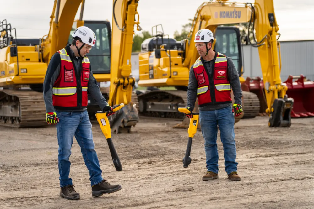
Unlike with GPR scanning, EM locators do not locate buried pipes or cables – they detect the electromagnetic signals radiating from metallic pipes and cables.
These signals can be created by the locator’s transmitter applying current to the pipe, or from current flow in a live electrical cable. They can also result from a conductive pipe acting as an antenna and re-radiating signals from stray electrical fields (detected by the EM locator functioning in Power Mode) and communications transmissions (Radio Mode).
By utilizing both GPR and EM locating, Dennis verified the location of multiple known lines and located several previously unknown utilities along the pipeline’s path. This ensured no subsurface damage occurred during excavation of the pipeline, keeping the project on time, on budget, and safe.
This use of complementary technologies is in alignment with the teachings of SIM, or Subsurface Investigation Methodology. The industry-leading training program and specification for utility locating, concrete scanning and video pipe inspection, SIM teaches that the use of multiple locating technologies during these investigations ensures a redundant confirmation of results. And SIM’s step-by-step approach to collecting subsurface data ensures that the results of locates are repeatable and accurate.
Every member of GPRS’ field team is required to achieve SIM certification. To do this, they complete a minimum of 320 hours of field training, as well as 80 hours of classroom training at GPRS’ state-of-the-art training center in Sylvania, Ohio.
It’s GPRS’ adherence to SIM that has led to us achieving and maintaining a 99.8%+ rate of accuracy on the over 500,000 utility locating and concrete scanning projects that we’ve completed to date.
Some of the utilities that Dennis located were buried as far as 4 feet below the surface.
The data collected and provided by Dennis allowed the contractor to adjust their plans to avoid costly and potentially dangerous subsurface damage during excavation.
The client shared with Dennis that they originally believed they would only need to contact their state’s 811 one-call service prior to digging. 811 is the national call-before-you-dig number, which contractors and excavators are required by law to contact prior to breaking ground.
It’s important to remember, however, that 811 contractors only provide the approximate location of public utilities. They do not provide the estimated location of private utilities – those owned and operated by individuals and businesses – which make up 60% of all buried lines.
If the contractor had followed their initial plan of only contacting 811, they wouldn’t have known the location of private utilities along their planned excavation path and subsurface damage would have likely occurred.
This is why it’s vital to hire a private utility locator like GPRS prior to breaking ground. Our private utility locating services compliment the services provided by 811 to mitigate the risk of subsurface damage during excavation projects.
From skyscrapers to sewer lines, GPRS Intelligently Visualizes The Built World® to keep you on time, on budget, and safe.
What can we help you visualize? Click below to schedule a service or request a quote today!
Frequently Asked Questions
What type of informational output is provided when GPRS conducts a utility locate?
Our Project Managers flag and paint our findings directly on the surface. This method of communication is the most accurate form of marking when excavation is expected to commence within a few days of service.
GPRS also uses a global positioning system (GPS) to collect data points of findings. We use this data to generate a plan, KMZ file, satellite overlay, or CAD file to permanently preserve results for future use.
Finally, all GPRS clients receive a complimentary SiteMap® Personal subscription with every utility locate. SiteMap® (patent pending) is GPRS’ cloud-based infrastructure mapping software solution that provides secure, 24/7 access to the field-verified data collected by our SIM and NASSCO-certified Project Managers. Click here to learn more.
Can GPR scanning find PVC piping and other non-conductive utilities?
Yes, GPR scanning is exceptionally effective at locating all types of subsurface materials. There are times, however, when PVC pipes do not provide an adequate signal to ground penetrating radar (GPR) equipment and can’t be properly located by traditional methods.
When GPR isn’t the right tool for the job, GPRS utilizes complimentary technology such as electromagnetic (EM) locating.
Will I need to mark out the utilities that GPRS locates?
No, GPRS will locate and mark all utilities for you. We have a variety of tools and markers we can use to highlight the locations of utilities, underground storage tanks (USTs) and whatever else may be hiding beneath the surface.
GPRS Conducts Utility Locating Services for Six Flags Solar Project
GPRS continues to help ensure the safe construction of the largest renewable energy installation in California history.
GPRS Project Managers have made several trips to Six Flags Magic Mountain in Los Angeles, where Six Flags Entertainment Corporation is constructing a 12.37-megawatt solar carport and energy storage system in partnership with Solar Optimum and DSD Renewables.
In a press release announcing the project’s official groundbreaking, Six Flags said that the project will rank as the largest single-site commercial renewable energy project in California and the largest solar project allocated toward a for-profit organization in the United States.
“We’re thrilled to be breaking ground on this monumental project and taking the next step towards a cleaner, greener future,” said Six Flags Magic Mountain Interim Park President, Jeff Harris. “We’re continuing to make advancements towards improving and protecting the environment, and are honored to be industry leaders, paving the way for other theme park companies around the world…”
Powering Up – Safely
About 4,243 billion kWh of electricity was generated at utility-scale electricity generation facilities in the U.S. in 2022, according to the Energy Information Administration.
About 22% (913 billion kWh) of this electricity generation was from renewable energy sources, which is about 2% more than in 2021. The EIA estimates that in 2024, renewables will make up 26% of our electricity generation.
Before any renewable energy project can get off the ground, however, proper precautions must be taken to ensure that installation can occur without damaging existing utilities or other subsurface objects.
GPRS Project Manager Vincent Lopez is one of the PMs conducting utility locating services at Magic Mountain in preparation for the installation of the solar array. The contractor needs to conduct directional boring to run conduit to connect the array to the park’s infrastructure, and they also need to pour footings to support the structure.
“They just wanted me to check the area, to see if there were any utilities that might be in the way,” Lopez explained. “They just wanted to make sure that there wasn’t anything that was going to get hit during the boring and excavation.”
GPRS Project Managers rely on Subsurface Investigation Methodology, or SIM, to guide them while conducting utility locates, precision concrete scanning and imaging, and video pipe inspections. SIM is the industry-leading training program and specification for subsurface investigation and requires that professional utility locating companies utilize multiple technologies and a repeatable process to ensure a redundant confirmation of results.
GPRS primarily uses two technologies when locating utilities: ground penetrating radar (GPR) and electromagnetic (EM) locating.
GPR is a non-invasive method that detects and visualizes objects beneath the surface, whether buried underground or embedded in structures like concrete.
The technology operates by transmitting radio waves into a structure and analyzing how these waves interact with subsurface features, encompassing both metallic and non-metallic materials. These interactions, often called "bounces," are captured by the GPR system and presented as hyperbolic patterns on a display, varying in size and shape according to the materials encountered.
Trained utility locating experts, such as GPRS’ SIM-certified Project Managers (PMs) and Area Managers (AMs), are adept at interpreting these patterns to identify the type of utilities or obstructions present and ascertain their approximate depths.
Unlike GPR scanning, EM locators do not directly locate buried pipes or cables. Instead, they detect the electromagnetic signals that emanate from metallic pipes and cables.
These signals might be generated when the locator's transmitter induces a current in the pipe, or they could come from the natural current flow within an active electrical cable. Signals can also be emitted from conductive pipes that act as antennas, picking up and re-radiating stray electrical fields (detected in Power Mode by the EM locator) and signals from communications transmissions (detected in Radio Mode).
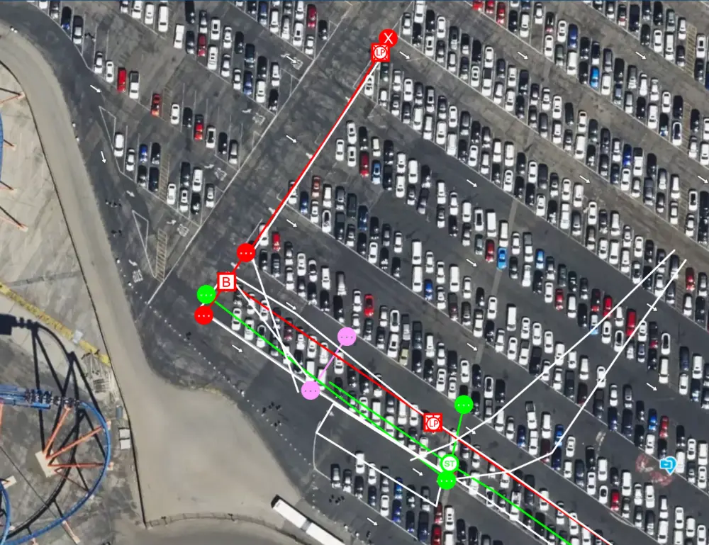
At Six Flags, Lopez first swept the area with his EM locator before verifying his findings with GPR scanning. In less than a day, he was able to clear the contractor’s desired boring paths and the other areas where excavation was going to occur, ensuring this high-profile renewable energy project could stay on time, on budget, and safe.
“We felt confident after locating everything with the EM locator, and I ran the GPR just to double check the whole area,” Lopez said.
As with every utility locating job GPRS completes, the data collected at Six Flags was instantly uploaded into SiteMap® (patent pending), our cloud-based infrastructure mapping software solution which allows for easy, yet secure access to this vital utility mapping information 24/7 from any computer, tablet, or smartphone.
All GPRS clients receive a complimentary SiteMap® Personal subscription when we perform a utility locate for them. With all your field-verified infrastructure data at your fingertips, SiteMap® allows you and your team to plan, design, dig, manage, and build better.
GPRS’ SiteMap® team members are currently scheduling live, personal SiteMap® demos. Click below to sign up for yours today!
Frequently Asked Questions
Does GPRS offer same-day private utility locating?
Yes, our professional Project Managers can respond rapidly to emergency same-day private utility locating service calls on your job site. In most cases, we can be on site within 24-48 hours.
How accurate are the results of ground penetrating radar scanning?
While accuracy depends on various external factors such as ground and soil conditions, the Subsurface Investigation Methodology (SIM) standard ensures that we can obtain the best results possible in each situation.
Through experience, we’ve found that when using a concrete antenna for scanning concrete, the accuracy is typically +/- ¼” to the center of the object and +/- ½” to the actual depth. When locating an object underground using a utility locating antenna for scanning, the accuracy is +/- 6” to the center and +/- 10% to the actual depth.
The results of the concrete antenna are generally higher resolution and therefore considered to produce better quality results. However, the concrete antenna cannot penetrate the ground as deeply as the utility locating antenna. It is critical to understand the benefits and limitations of both when performing scanning work.
GPRS Project Managers use electromagnetic (EM) locating to compliment GPR and ensure you receive the most accurate infrastructure data possible.
Distracted Driving is a Construction Safety Issue
GPRS’ commitment to safety doesn’t stop at the boundaries of the job sites where we help you Intelligently Visualize The Built World®.
Both our team and yours need to drive safely to get to and from their projects. And with April recognized nationally as Distracted Driving Awareness Month, and Construction Safety Week 2024 running May 6-10, now is the perfect time to remember the vital role we all play in keeping ourselves and our coworkers safe while on the road.
Distraction-affected fatal crashes have increased 4% since 2013, despite a 5% decrease in these incidents in 2022 compared to 2021, according to data from the National Safety Council.

Not surprisingly, the percentage of drivers manipulating hand-held electronic devices – including texting – has increased 82% over the same time period.

“What I continue to see from a data perspective is we have a problem with using devices while driving,” said Chris Moore, GPRS’ Senior Vice President of Internal Operations. “According to the National Highway Traffic Safety Administration, nearly 300,000 accidents last year were a result of distracted driving in some way, shape, or form… There’s just a level of vigilance needed, and I think we just don’t think about it.”

Moore is leading an internal team at GPRS working educate our team members on the dangers of driving distracted. And every vehicle in GPRS’ fleet is equipped with Bluetooth technology, as our team members are prohibited from using hand-held mobile device while behind the wheel.
“Vehicle safety is the number one safety risk that our company faces on a daily basis,” Moore said. “It’s not the risks of being on job sites… It’s our guys behind the wheel, driving 12,000,000-plus miles a year. That’s our biggest safety risk.”
“It’s so important, thinking about it certainly for the safety of our team members and then also for our vehicle fleet,” Moore continued. “And then, thirdly, for insurance rates. [If you don’t take steps to educate your team on the dangers of distracted driving,] trending data shows that someone is going to have a severe accident, and somebody is going to get tremendously hurt.”
According to the National Conference of State Legislatures, 27 states, Washington, D.C., Guam, Northern Mariana Islands, Puerto Rico, and the U.S. Virgin Islands prohibit all drivers from using hand-held cellphones while driving.
Of course, distracted driving means more than just fiddling with your mobile device. It’s looking down to adjust an air vent, turning around to reprimand a child in the backseat, or looking over your shoulder to – ironically – gawk at an accident.
When distracted driving occurs behind the wheel of a company-branded vehicle, that company’s reputation is on the line.
“With distracted driving, everybody does it – self included – right?” Moore said. “And we don’t really say anything about it. Everybody knows it’s bad, but we don’t hold each other accountable… So, specifically in the construction industry: are we willing to look at another contractor and be like ‘Hey dude, I’d appreciate if you’d put that phone down’? There’s some reputational risk, organizational risk, and relationship risk to that, right?”
Moore suggests you “own the awkwardness” when you need to urge a coworker to stay focused behind the wheel.
“If I saw you in the parking lot using your phone as you drove through the parking lot and felt compelled to say something, I would say ‘Hey man, listen, I’m about to say something that’s super awkward, and I don’t know how to say it well, and I’m sorry, but do you need to be using your phone while you’re driving?’” he said. “There are ways in which we can kind of cache it that aren’t attacking and that sort of put us in a humble position.”
At GPRS, safety is always on our radar. Our subsurface damage prevention services, including precision concrete scanning, utility locating, video pipe inspection, and leak detection, are designed to keep you and your team safe so you can leave the job site in the same condition in which you arrived to it.

But all that work is meaningless if you or a member of your team gets into a fatal accident on your way to or from your site.
You can click here to sign up for more resources to help you and your team stay safe behind the wheel.
It’s also not too late to sign up for your free Construction Safety Week presentation. From May 6-10, GPRS safety experts will travel the country offering free safety presentations to you and your team, at your site or office.
Click here to schedule your CSW presentation today!
Frequently Asked Questions
What is considered distracted driving?
Distracted driving refers to operating a vehicle while engaged in other activities that divert the driver's attention away from the road. Common distractions include using a cellphone, eating, using a GPS, and talking to passengers.
There are three main types of distractions:
- Visual: taking your eyes off the road (e.g., looking at a smartphone)
- Manual: taking your hands off the wheel (e.g., eating or adjusting the radio)
- Cognitive: taking your mind off driving (e.g., having a conversation or daydreaming)
Why is distracted driving dangerous?
Distracted driving increases the risk of a vehicle crash as it impairs the driver's ability to make quick decisions, react to sudden changes, and maintain awareness of road conditions and traffic laws.
What are the consequences of distracted driving?
Consequences can range from minor vehicle damage to serious accidents causing injuries or fatalities. Legally, it can lead to fines, license suspension, and increased insurance rates. In severe cases, it can result in criminal charges.
Are there laws against distracted driving?
Yes, many regions have specific laws that prohibit texting and the use of hand-held mobile phones while driving. Some places also have broader laws against any activity that impairs a driver's ability to safely operate a vehicle.
How can distracted driving be prevented?
Preventative measures include:
- Turning off electronic devices or setting them to "Do Not Disturb" while driving.
- Pre-setting GPS and climate controls before departure.
- Avoiding eating, drinking, or other activities that require manual involvement while driving.
- Educating drivers, especially teens, about the risks of distracted driving.
What is Construction Safety Week?
CSW is an opportunity for people, companies, and even competitors to work together and celebrate the incredibly hard work by people in the construction industry who make safety the foundation of everything they do. Click here to learn more.
Is There a Cost-Effective Construction Documentation Method?
3D Photogrammetry is a Low-Cost Investment with Many Benefits
Imagine having instant access to your site’s spatial data at any point during the construction process, including measurements, floor plans, and virtual tours for a fraction of the cost of 3D laser scanning. How would that change your team’s workflow and productivity?
Many clients would benefit from a walkthrough of their site during different stages of construction. 3D photogrammetry can deliver a 3D virtual record of the project before, during, and after construction. Now imagine having this as-built documentation quickly at a low-cost.
GPRS 3D photogrammetry services use a professional-grade 3D camera to capture high-resolution 360° images and LiDAR point clouds. GPRS 3D photogrammetry offers 20mm accuracy within a 10m range and has a maximum of 100m scanning range. It takes less than 20 seconds per scan location to collect more than 100,000 data points. Clients receive an immersive and interactive walkthrough of their building’s architecture, structure, utilities, and MEP systems in real-time.
Photogrammetry is a low-cost existing conditions construction documentation investment that can quickly transform sites into digital twins. The technology captures layout and dimensional data in color, and clients can import e57 point clouds and .OBJ files directly into CAD or BIM modeling software.
Existing condition documentation by way of 3D photogrammetry can be used to design modifications and upgrades before beginning construction. It can record the location of utilities, concrete reinforcements, and MEP installations. It can also provide progressive capture on a jobsite so everyone can see what’s been done and what milestones are still to be completed. Plus, it can provide a virtual tour of a site upon project completion.
Recent GPRS 3D Photogrammetry Services
A power company that delivers electricity and gas to Massachusetts customers and communities requested a GPRS WalkThru 3D of the utility locate for their site.
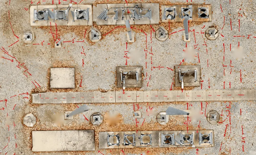
A water company that manufactures and supplies water dispensers and multi-gallon bottled water to retail locations requested GPRS 3D photogrammetry of their facility.

An architect requested GPRS as-builts prior to remodeling existing warehouse space and the installation of new machining and manufacturing equipment. They needed to understand all underground electrical, plumbing, sewage, and compressed air lines before construction to make sure they did not damage the existing systems.
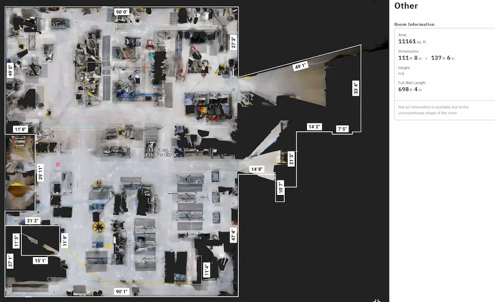
To efficiently plan and manage your project and keep it on time and on budget, reach out to one of GPRS’ 500 Project Managers located across the United States. Our Project Managers will quickly mobilize to document your site in photo-realistic 3D. Our in-house Mapping & Modeling Team rectifies the 3D photogrammetry to digitize your site into WalkThru 3Ds, floor plans (FLRPLN), progressive capture (PRO CAP), and TRUBUILTs.
With 3D photogrammetry, clients can digitize and view their space, get accurate measurements, design modifications, and more. GPRS offers project executives, general contractors, and field teams a comprehensive set of add-on tools to receive as-built data, make informed decisions, and optimize construction design and workflows.
WALKTHRU 3D VIRTUAL TOURS
Receive accurate existing condition documentation, as-builts, and dimensional information in real time with WalkThru 3D Virtual Tours. GPRS uses 3D photogrammetry to provide immersive site walkthroughs and 3D virtual tours that allow project teams, designers, and stakeholders to remotely walk through a site or facility. WalkThru 3D eliminates travel and improves communication and collaboration. It also allows clients to intelligently visualize their site, identify potential issues, and make informed decisions without the need for physical presence.
WalkThru 3D can be delivered digitally and accessed via SiteMap® so that your virtual tour can be downloaded, saved, and shared to any laptop, tablet, or smartphone, and is accessible 24/7.

FLRPLN
The GPRS Mapping & Modeling Team can take the rectified, real-time 3D photogrammetry from WalkThru 3D and create an accurate existing condition as-built floor plan of a project site for design planning, risk mitigation, and emergency planning purposes. FLRPLN is a precise 2D CAD construction drawing that provides project teams accurate layout, dimensions, and details of a building or structure. It helps everyone visualize the project site, communicate with clients and contractors, and comply with codes and regulations. FLRPLN can be used to identify potential hazards, develop emergency action procedures, safety protocols, and train personnel on site-specific procedures.
GPRS FLRPLN can be delivered digitally and accessed via SiteMap® so that it can be downloaded, saved, and shared to any laptop, tablet, or smartphone and is accessible 24/7.

PROCAP
PRO CAP Progressive Capture can document construction progress from start through completion with 3D photogrammetry. GPRS’ Project Managers can accurately record the precise details of a project site from the location of utilities and concrete reinforcements to MEP installation locations, and more with 3D rectified imagery. We can provide PRO CAP on a regular schedule for the life of a project, whether it be bi-weekly, monthly, or customized to a client’s needs.
By capturing scans regularly, clients can track the evolution of the site, monitor construction milestones, manage project timelines, and ensure that work is proceeding according to schedule. Accurate record images can help to avoid clashes, change orders, and streamline communications.
PRO CAP Progressive Capture is valuable when managing projects from a remote location or managing multiple project sites.
PRO CAP scans can be delivered digitally and accessed via SiteMap® so that they can be downloaded, saved, and shared to any laptop, tablet, or smartphone and are accessible 24/7.
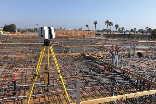
TRUBUILT
Eliminate outdated and inaccurate as-builts with TRUBUILT, real-time reality capture 2D CAD plan views of infrastructure – above and below ground. TRUBUILTs are accurate existing condition as-builts of a site or facility. They break down information silos and allow team members to collaborate with comprehensive, layered, data. TRUBUILT as-builts can serve as comprehensive documentation for reference, maintenance, and renovation projects.
Clients can access, copy, download, and share TRUBUILT as-builts via SiteMap® to keep their projects on time, on budget, and safe.

What is SiteMap®?
GPRS recently developed SiteMap®, a cloud-based user-friendly software that quickly and securely delivers 3D photogrammetry data, maps, and models for construction and infrastructure projects. SiteMap® provides customers with GPRS accurate as-built information – from our 99.8%+ accurate utility maps & concrete imaging results to CAD drawings and fully integrated 3D BIM models that meld 2-4mm accurate aboveground as-builts & below ground infrastructure to create a digital twin of any site.
3D photogrammetry can be accessed via SiteMap® to view site documentation, make informed decisions, coordinate work, and minimize errors. Clients can share data easily with team members, digitally measure inside 3D photogrammetry files, and use features like annotation, markup, and feedback to communicate with team members, clients, and contractors.

Why GPRS? The GPRS Difference.
GPRS reality capture services Intelligently Visualize The Built World® to create a digital representation of the real-world conditions of a construction site or an existing building.
GPRS utilizes 3D photogrammetry for reality capture to deliver accurate as-built data to construction professionals to make informed decisions and manage and execute projects. 3D photogrammetry enhances accuracy, efficiency, safety, and communication throughout the entire construction process, from initial design to project completion.
If your project requires a higher level of accuracy, GPRS also offers 3D laser scanning that provides 2-4 millimeter accurate records of existing as-built conditions. 3D laser scan data can be processed by our in-house Mapping & Modeling Team to deliver point cloud files, 2D CAD drawings and 3D BIM models to help you plan, design, manage, and build better.
With over 500 Project Managers in every major city across the United States, GPRS has an unmatched nationwide service network that makes it quick and easy to find local experts. GPRS specializes in 3D laser scanning, 3D photogrammetry, asset digitization, 3D virtual tours, digital twins, scan to CAD, and scan to BIM for the in the AEC industry.
What can we help you visualize?
Frequently Asked Questions
What is the Meaning of Photogrammetry?
When you break down the word photogrammetry – “photo” refers to light, “gram” means drawing and “metry” refers to measurements. Photogrammetry uses photos to gather measurements from which drawings, maps, models, and virtual tours can be created.
What are the Benefits of Photogrammetry?
- Permanent record of existing conditions
- Fast 2D and 3D data collection
- Accurate virtual models of physical assets, structures, and systems
- Digital twins and virtual site tours
- Eliminates the need for site revisits
- Minimal disruption to environment
- Saves time compared to conventional ground surveys
- Non-intrusive and cost effective
- Expedites decision making, increasing project efficiency
What Industries Use Photogrammetry?
Photogrammetry can be used in many industries: construction, civil engineering, structural engineering, telecommunications, military intelligence, agricultural, cultural heritage & preservation, real estate, film & entertainment, public safety, forensics & accident investigation, archaeology, and more.
How GPRS Manages Large Point Cloud Datasets
Engineers and contractors have more project data than ever before thanks to 3D laser scanning technologies such as LiDAR (light detection and ranging) and photogrammetry. These methods of reality capture collect millions of data points and store them in the form of a point cloud. The point cloud generated from laser scanning and photogrammetry is important for construction planning because it provides a highly accurate and detailed representation of a building or site.
What is a Point Cloud?
According to US CAD, “laser scanners digitally capture objects using laser light. The result is a point cloud consisting of millions of points that produce a highly accurate 3D representation of the as-built conditions. A point cloud can be easily imported into leading CAD and BIM software solutions to further use in the design and construction process.”
GPRS defines a point cloud as a collection of data points in a 3D coordinate system. Each point in the point cloud is defined by its XYZ coordinate, and may also include additional attributes such as color, intensity, and reflectance. The reflectance characteristics of each LiDAR point cloud document the reflectance properties of points to known values (high, medium, low) which are characteristic of commonly classified features, such as vegetation, asphalt roads, buildings, and water bodies.
To 3D laser scan a site, a GPRS Project Manager positions a laser scanner at various locations, taking individual scans from varying viewpoints to capture comprehensive site data. A single scan from a 3D laser scanner can generate millions of individual points or XYZ coordinates, each representing a specific location in the 3D space. The captured points record every surface color, detail, and texture, creating a direct representation of the scanned project site with 2-4 millimeter accuracy.
The size of a point cloud can vary significantly depending on several factors, including the resolution of the scan, the area covered, and the level of detail captured. For example, a laser scan of a large building could produce a point cloud with billions of points. Higher density scans capture more points per area and provide a more detailed and accurate representation of a space, resulting in an even larger point cloud file size.
Projects can include hundreds of laser scans, stored in large files that can create datasets in excess of a terabyte. Registering, storing, and manipulating these large datasets can be challenging.
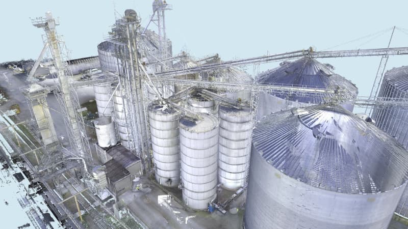
Why is Point Cloud Registration Important?
Registering a 3D laser scan point cloud involves aligning multiple scans of the same area taken from different positions into a single, coherent point cloud. The registration process can be complex and time-consuming, especially for large and detailed point clouds. Getting the registration right ensures the most accurate measurements, drawings, and models.
GPRS Project Managers are trained to acquire data in ways that allow for good, tight registration. They capture multiple scans of the site from different positions, ensuring that there is sufficient overlap between scans.
The Mapping & Modeling Team combines the aligned scans into a single, merged point cloud. The team converts raw scan data to Autodesk ReCap scan files (RCS files) and project files (RCP files). They perform quality checks on every point cloud, removing noise, setting the coordinate system, checking for any misalignments or inconsistencies, and validating the precision of the registration. The team makes sure all the scans fit together exactly as they should, so that a client’s point cloud and models will have tight lines and accurate measurements.
GPRS has a team of experts who can register datasets of any size. We have completed projects with thousands of individual scans, on sites that are hundreds of acres large, and with miles of piping. No matter how big or small a project, GPRS provides client’s with the most precise point clouds to create accurate 2D drawings and 3D models.
How Does GPRS Manage Large Point Cloud Data Sets?
Once the point cloud is registered, it can be exported to a client for analysis, visualization, or processing. By consulting with the GPRS Mapping & Modeling Team, we can implement different strategies to effectively manage large point cloud datasets for our client’s architecture, engineering, and construction projects.
- Data Storage: We recommend that our clients use a storage solution that can handle large datasets efficiently. This might include cloud storage services, network-attached storage (NAS), or dedicated storage servers.
- Data Compression: We can use data compression techniques to reduce the size of the point cloud files without significantly affecting their quality. GPRS is also able to reduce the file size of the point cloud by creating unified RCS files or dividing a project into multiple RCS files to use individually.
- Data Streaming: Instead of loading the entire point cloud into memory at once, we recommend streaming techniques to load and process the data in chunks. This can help reduce memory usage and improve performance.
- Level of Detail (LOD): Our Mapping & Modeling Team can generate multiple levels of detail for the point cloud data, with higher levels of detail for areas of interest and lower levels of detail for less important areas. This can help reduce the overall size of the dataset while still maintaining important details.
- Data Filtering: We can use filtering techniques to remove unnecessary or redundant points from the dataset. In ReCap, we can drastically reduce the point cloud file size by changing the spacing between the unified points. We can use point decimation techniques to reduce the point cloud resolution by omitting a certain number of pixels in rows, columns, or both columns and rows. We can also remove points that are outside the area of interest or that represent noise in the data. For example, we can crop the data down to not show superfluous data, like removing data from across the street.
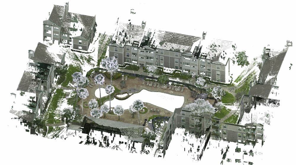
What Are the Applications of Point Cloud Data?
Point cloud data has become the new standard in pre-design planning for the architecture, engineering, and construction industries. Having a virtual dataset of the project site gives our clients’ the ability to utilize real-time data for decision making.
Point clouds are used to create 2D CAD drawings and 3D BIM models to expedite the planning, design, construction, and management of construction and infrastructure projects.
GPRS is a leading provider of 3D laser scanning and 3D photogrammetry services, helping clients to successfully complete their most complex projects with accurate as-built documentation, point clouds, 2D CAD drawings, and 3D BIM models.
What can we help you visualize?
Frequently Asked Questions
What is photogrammetry?
Photogrammetry is the process of capturing images and stitching them together to create a digital model of a structure or site for visualization and analysis. It is a fast way for architecture, engineering, and construction teams to document accurate as-built site conditions.
What is 3D laser scanning?
3D laser scanning uses LiDAR technology to capture as-built documentation of existing buildings or sites. Once data is acquired, a point cloud is generated and used to develop 2D CAD drawings or 3D BIM models, expediting the design, planning, and development of projects.
What scanners are used for data collection?
GPRS utilizes a terrestrial 3D laser scanner for data collection, as they are able to document vertical structures, such as buildings and facilities. These scanners sit on a tripod and can take 1-3 minutes to complete each scan, depending on the project requirements. Terrestrial laser scanners are known to produce the most accurate point clouds due to the fact that they are stationary. A laser scanner can only capture what is in its line of sight. Scanners are positioned around a site and take individual scans from varying viewpoints to capture complete site data. The captured points record everything from surface detail and texture, to color, creating a direct representation of the scanned project site.
Navigating the Currents: Addressing the Critical Threats to Water Infrastructure
Water infrastructure is the backbone of modern society, ensuring the safe delivery of drinking water to our homes and businesses.
This vital system, however, is under siege from various threats that jeopardize its integrity and functionality.
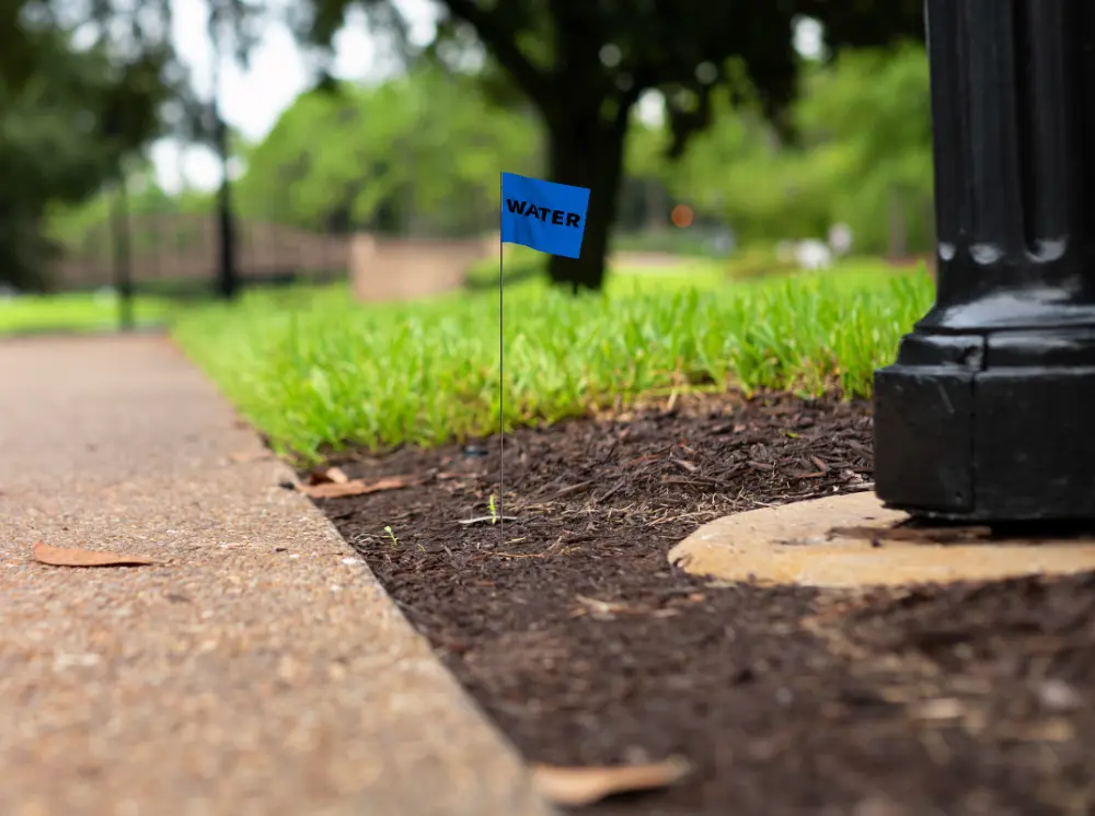
Aging Infrastructure: A Ticking Time Bomb
One of the most pressing threats to water infrastructure is its age. In many parts of the world, water systems nearing the end of their designed lifespans. This aging infrastructure is more susceptible to leaks, breaks, and system failures.
The American Society of Civil Engineers (ASCE) has consistently given poor grades to the nation's water infrastructure, highlighting the urgent need for upgrades and repairs. In its most recent Infrastructure Report Card, the ASCE gave our drinking water infrastructure a C-.
“Our nation’s drinking water infrastructure system is made up of 2.2 million miles of underground pipes that deliver safe, reliable water to millions of people,” the ASCE wrote.
“Unfortunately, the system is aging and underfunded. There is a water main break every two minutes and an estimated 6 billion gallons of treated water lost each day in the U.S… Enough to fill over 9,000 swimming pools…”
The Silent Culprit
Leaks are a pervasive problem in water distribution systems. They not only waste valuable water resources, they also lead to significant financial losses for utilities. Advanced leak detection technologies, like acoustic sensors and smart water meters, are becoming increasingly important in identifying and locating leaks early, before they escalate into major breaks. By investing in these technologies, utilities can reduce non-revenue water (NRW) loss and extend the life of their infrastructure.
Non-Revenue Water Loss: An Economic Drain
Non-revenue water (NRW) loss, which includes water lost to leaks, theft, and metering inaccuracies, is a financial drain on water utilities. It represents water that is produced and treated but not billed to customers, leading to lost revenue. Reducing NRW is essential for the financial sustainability of water utilities and for ensuring the efficient use of water resources. Implementing comprehensive water audit programs and adopting smart water management solutions can help utilities minimize NRW and improve their bottom line.
Inflow and Infiltration: The Hidden Flood
Inflow and infiltration (I/I) are processes that allow extraneous water to enter sewer systems, often overwhelming wastewater treatment plants and leading to untreated sewage discharges into the environment. Inflow occurs when stormwater directly enters the sewer system through improper connections, while infiltration happens when groundwater seeps into the sewer pipes through cracks and leaks. `a multi-faceted approach, including repairing and replacing damaged pipes, disconnecting improper connections, and implementing green infrastructure to manage stormwater at its source.
Climate Change: A Rising Tide of Challenges
Climate change poses an increasingly significant threat to water infrastructure. Rising sea levels, more intense storms, and changing precipitation patterns can lead to coastal flooding, increased stormwater runoff, and more frequent and severe droughts. These challenges require water systems to be more resilient and adaptable. Investing in climate-resilient infrastructure, such as flood-resistant pump stations and drought-tolerant water sources, is crucial for ensuring the long-term sustainability of water systems.
Urbanization: The Pressure of Growth
Rapid urbanization is putting additional pressure on water infrastructure. As cities grow, so does the demand for water services, which can strain existing systems. Moreover, urban sprawl can lead to more impervious surfaces, exacerbating stormwater management challenges. Sustainable urban planning, including the integration of green infrastructure and smart water technologies, is essential for managing the impacts of urbanization on water systems.

GPRS Leak Detection Keeps Your Water Where it Belongs
The threats to water infrastructure are diverse and complex, but they are not insurmountable.
By prioritizing investments in modernization, embracing innovative technologies, and adopting sustainable practices, we can safeguard our water systems for future generations.
It starts by ensuring your water stays where it belongs.
Even a small leak in a water system can have big consequences. That’s why GPRS offers underground water leak detection services designed to mitigate the risk of NRW loss and other threats to your water infrastructure. We can quickly pinpoint a known leak when a problem has been identified, or proactively search for leaks along a domestic pressurized water or fire system for a municipality or facility.
GPRS uses two primary technologies for our leak detection services:
1. Acoustic Leak Detection
Acoustic leak detection involves using sophisticated ground microphones to listen for leaks coming from pressurized subsurface pipes. Our Project Managers (PMs) are acoustic leak detection specialists who are thoroughly trained to pinpoint leaking pipes’ specific sounds and frequencies.
Pipes made of metal, such as cast iron/ductile mains, smaller copper service lines, and steel pipes transmit water leak sounds over longer distances than pipes made of PVC or asbestos-cement. Accordingly, our PMs consider the pipe material and its size when determining how best to evaluate your water system. Small diameter pipes are more likely to transmit more sound than large diameter pipes, regardless of their material. Large diameter pipes transmit lower frequency sounds than small diameter pipes.
2. Leak Noise Correlators
Leak detection, or leak noise correlators are specialized electronic devices that professional leak detection service companies like GPRS use to quickly and accurately locate leaks in water lines. Sensors are placed on both sides of the pipe, and these sensors send information back and forth between each other via radio. An automated process identifies each suspected underground water leak location and displays it on the main control unit. The processing unit then compares this data with mathematical algorithms designed for the specific noise profiles of the pipe material being tested, determining where the leak is coming from between each sensor’s location.
Our Project Managers map out leaks using the data collected with leak detection correlators, then pinpoint the leaks using acoustic leak detection equipment.
From skyscrapers to sewer lines, GPRS Intelligently Visualizes The Built World® to keep your projects on time, on budget, and safe.
What can we help you visualize? Click below to schedule a service or request a quote today!
Frequently Asked Questions
How many miles of pipe can GPRS test for leaks in one day?
The amount of pipe we can test often depends on the experience of the leak detection specialist. Team members with many years of experience can test up to 10 miles of pipe a day on a metallic system (cast iron/ductile). Experienced leak detectors can test a contact point (hydrant/valve) within a minute before moving on to the next one. Leak detectors can work efficiently because they are trained to hear the specific tone that a leak produces compared to any other number of noises a general environment makes.
Why do you have to work in the early hours of the morning?
Our acoustic listening equipment is highly sensitive and amplifies leaks and other noises which mask leak signals during the day. If we work in city environments, there is often a significant amount of ambient noise. This noise includes airplanes, traffic, mowers, machinery, and most importantly, people using water. It is up to the leak detection specialist to determine if night work should be utilized to minimize all other noise to focus on the leak signal.
Why don’t I see any water at the location where you’ve pinpointed a leak?
Water finds the path of least resistance. Water can run through cracks in subsurface rock or make its way into storm, sanitary, and conduit piping. If the subsurface contains a high volume of sand, it will naturally flow farther down. There is no water visible on the surface in over 99% of the leaks we locate.