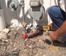
///STOP HITTING UTILITIES

Utility detection is critical to any project where subsurface excavation is planned to ensure success and avoid utility strikes. To achieve a comprehensive, safe utility locate, a private utility locating company must be utilized to mark & map buried facilities on private property. Professional utility locators with proper training, multiple technologies, and field-tested methodology are essential to properly locating all site utilities.
Private Utility Locating
Facility Mapping
Utility As-Built Creation
Soil Boring Clearance
Directional Drilling Clearance
Environmental Due Diligence
One Call Locating Services
UST Locating
Private Utility Locating Services
65% of all on-site utilities for virtually any construction project or facility are private, meaning 811 One Call services cannot locate them for you. GPRS provides comprehensive digital and PDF utility maps of every utility on site, whether public or private – including depths – and can export your utility data into a wide variety of drawings, maps, and models that provide seamless communication and collaboration on any project.
Facility Mapping Services
GPRS’ mission is to Intelligently Visualize The Built World®. We provide comprehensive above and below ground facility and infrastructure mapping for the construction, facility management, engineering, architecture, manufacturing, and related industries. Our services provide accurate 3D BIM models, 99.8% accurate utility locating & concrete imaging via GPR, NASSCO-certified Video Pipe Inspection (CCTV) reports, 2D CAD drawings via FLRPLN, Conceptual Site Models (CSM), rectified 3D photogrammetry via ProCap & 3D virtual tours via WalkThru 3D.
Directional Drilling Clearance
When installing fiber and telecom lines, you have to know where to drill to avoid striking existing underground utilities. Cross bores caused by trenchless technology risk utility infrastructure and community safety. Avoid damages and confirm the safety of your work with pre and post-installation cross bore inspections that capture accurate existing conditions underground before you drill, and confirm the safety of your completed work.
Environmental Due Diligence & CSM
GPRS provides assistance in Phase I and Phase II Environmental Site Assessments (ESAs), whether for due diligence before a sale or when tracking potential contamination for regulatory concerns. We provide accurate utility locates that map preferential pathways for contaminants and can provide detailed and 99.8% accurate conceptual site models (CSM) for 3D site visualization.
One Call Locating Services
Calling 811 before you dig is the law, and One Call will connect you with public utility contractors who will provide you with the location of all public utilities near your excavation. However, One Call cannot provide locates for the private utility lines on site, nor do they provide depths for public utility lines. GPRS professional private utility locating can locate both public and private utilities, provide accurate field markings, including depths, and give you complimentary digital and PDF utility maps of your utility infrastructure.
UST Locating
Finding underground storage tanks (USTs) on any site is crucial to remediating risk before excavation. Abandoned tanks and lines can be easily found and comprehensively mapped by our SIM-certified Project Managers, and our Mapping & Modeling team can create a comprehensive map and/or conceptual site model (CSM) of your facilities for risk mitigation and recording purposes.
Soil Boring Clearance
Environmental consultants require soil borings when providing due diligence in a property transfer or when investigating environmental hazards in contaminated areas and brownfields. Knowing what utilities and features exist underground before you drill can help mitigate additional damages and risk in an already hazardous situation.
Utility As-Built Creation
GPRS provides a complimentary PDF, .KMZ file, and a SiteMap® Personal subscription with every outdoor utility locate. Our Project Managers utilize the data from your utility field markings to create digital, layered utility maps inside SiteMap®, and our in-house Mapping & Modeling Team can provide you with TruBuilt plan views and even a comprehensive 3D BIM or Conceptual Site Model (CSM) that accurately visualizes your entire utility infrastructure to communicate, collaborate, and manage your project or facility better.

///PROJECT CYCLE SOLUTIONS

Data Control = Damage Control, which means you save time, money, and keep your people safe.
Project Cycle Solutions Graphic | GPRS
Planning & Design
GPRS provides accurate existing condition documentation for underground utilities to streamline planning & design by Intelligently Visualizing The Built World® with a wide variety of maps, drawings, and even 3D models of your subsurface infrastructure to help you plan and execute better.
Construction
Controlling your subs, trades, and the quality of your data is vital to a safe, successful project. That’s why before you break ground, it’s critical to accurately visualize your subsurface utilities. Whether you choose to incorporate Subsurface Investigation Methodology to your dig policy, or utilize GPRS locates and cross bore mitigation before you drill or dig, our services provide you with the control you need to dig more safely and build better.
O&M/Remodel
Facility Management is a constant struggle to maintain accurate existing condition documents and to have your as-builts easily accessible to your team. Eliminate information bottlenecks and keep your facility documentation up to date with GPRS and our SiteMap® platform – our cloud-based application that incorporates GPRS 99.8% accurate utility data with an intuitive GIS user interface to manage your facility infrastructure.

///THE RIGHT TOOLS

Ground Penetrating Radar
The tool our company was founded on, GPR, in concert with other complementary technologies, is used to identify buried objects and underground utilities. Our Project Managers provide 99.8% accurate field-verified utility maps, delivered via SiteMap®, PDF & .KMZ files to all GPRS customers.
EM Locating - Active
Active EM locating involves actively transmitting a frequency through the underground utility’s conductive material. This is done by connecting through various points depending on the utility. The transmitter can be connected to various types of utility lines via a grounding wire or other physical utility structure above ground to provide the active signal that the EM locator can then read.
EM Locating - Passive
Electromagnetic (EM) locators are preferred by One Call contractors to locate public utility lines. GPRS utilizes them with GPR and other technologies as part of our Subsurface Investigation Methodology process to detect live AC power or radio signals along conductive utilities.
Electromagnetic Induction (EMI)
Electromagnetic Induction (EMI) is used in open-field metal surveys to locate buried objects. The EMI unit has two coil sets: one transmits a primary magnetic field, inducing current in the ground, and the other senses the secondary magnetic field. EMI data reveals soil conductivity and is displayed as a color-coded contour map showing conductivity changes.
Robotic CCTV Crawlers
GPRS Project Managers use CCTV to investigate sanitary & storm sewers as part of our Video Pipe Inspection Services. Mainline crawlers and their small diameter cousins are used with push cameras and other technology to provide accurate, subsurface visualization and NASSCO-certified reporting.
Push Camera
Push cameras can access pipes through smaller spaces like vents, cleanouts, and toilet plumbing to locate small lateral lines in a sewer system. It contains a sonde that can also be detected by an EM locator to map non-metallic pipes as part of a full site utility scan or NASSCO VPI report.
CCTV Lateral Launch Cameras
GPRS uses lateral launch cameras as part of a video pipe (CCTV) inspection and/or a full-site utility locate to non-destructively investigate lateral storm and sanitary sewer lines upstream of a mainline to find pipe defects, cross bores, abandoned pipes, and effectively map a sewer system.
Sondes
Sondes are built into robotic crawlers and push cameras and emit an electromagnetic field that is receivable by EM locators or a sonde locator. They allow GPRS Project Managers to accurately map sewer lines as part of a utility locate or video pipe inspection.
Acoustic Leak Detection
GPRS Project Managers are experts in acoustic leak detection for pressurized water lines. They use specialized microphones, headphones, and control units, and complementary technologies to pinpoint water leaks by listening to amplified sound waves in a wide variety of pipe materials.
Leak Detection Correlators
Also known as leak noise correlators, these algorithm-powered assessment tools utilize radio waves via a dual sensor system to process and digitally display leak vibrations that correlate to potential pressurized water system leaks. This tool is used in conjunction with acoustic detection devices to provide pinpoint leak detection in water and fire suppression infrastructure.

Put your site on the Map///

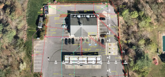
///Georeferenced Utility Linework Overlay

GEOREFERENCED UTILITY LINEWORK OVERLAY | GPRS

Every GPRS customer receives a complimentary PDF and .KMZ file of their utility map. Plus, we also provide a layered, georeferenced, and 99.8%+ accurate interactive digital utility map via SiteMap® for every utility locate or full site scan we provide. All GPRS customers receive a complimentary SiteMap® Personal subscription with their utility locate so that their subsurface utility information is secured and accessible 24/7 via desktop or mobile devices via the SiteMap® Mobile App.

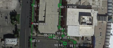
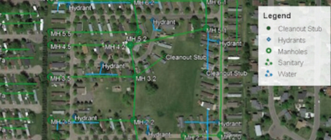
///CAD – 2D Utility Site Plan

CAD - 2D UTILITY SITE PLAN | GPRS

If you need accurate existing condition documentation in 2D format for contractors, trades, and engineers, the GPRS Mapping & Modeling Team has you covered. We can convert your utility field markings, captured with either 3D photogrammetry or LiDAR (3D laser scanning) to create accurate CAD as-builts of your utility infrastructure. Learn more about our CAD team, here.

///CAD – 3D UTILITY SITE PLAN

CAD 3D Utility Site Plan – VDC Coordination Example | GPRS

GPRS can locate every feature and facility, above and below-ground, and with the help of 3D technology, can capture those 99.8%+ accurate measurements to create a comprehensive 3D BIM model or conceptual site model (CSM) of your site. Our Mapping & Modeling team can even create an integrated model using utility markings and 3D laser scans to provide an accurate 3D object that incorporates all of your above and below-ground features, and even proposed changes, to help you design, plan, and build better. Learn more about 3D utility and facility modeling, here.

///GIS Infrastructure Software Application

SiteMap - GIS Infrastructure Software Application on Mobile and Desktop | GPRS

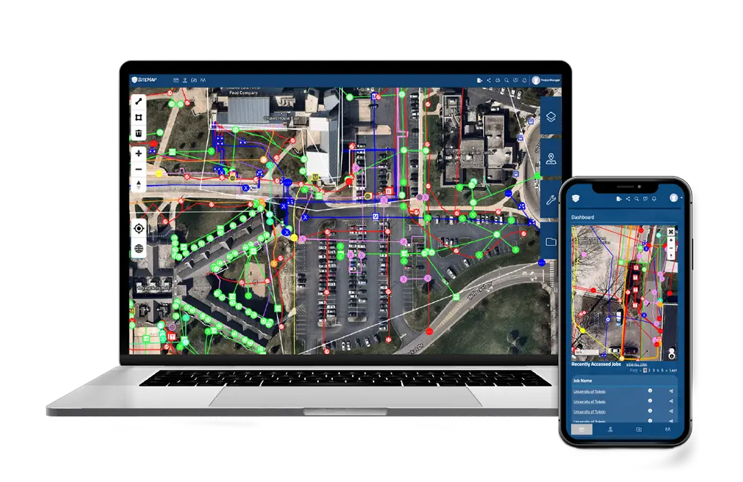
Every GPRS customer receives their digitized, secured, and accessible utility locates, maps, and models via SiteMap®, our GIS-based infrastructure and facility management software application. In most cases, your utility locating information and layered utility map will be available within five minutes of the completion of your job, so that you can control the quality of your utility data, secure it, and share it with those you designate. GPRS customers receive a complimentary SiteMap® Personal subscription with any GPRS job. Learn more about SiteMap®, here.

Learn More

///GPRS COMMITMENT

DATA CONTROL = DAMAGE CONTROL

GPRS commits to:

Provide elite project managers with a proven 99.8% accuracy rate
Utilize multiple complementary technologies to locate and identify subsurface utilities and/or embedded features
Follow industry-leading SIM protocols to get the most accurate results, everywhere, everytime

YOUR NEXT STEPS:

Hire only SIM-certified contractors for locating and concrete scanning
Provide an explicit dig policy for your crews that specifies the use of SIM protocols
Put data accuracy and safety at the top of your list
Construction worker icon | GPRS
FACILITY MANAGERS
Accurate utility infrastructure data prevents costly strikes, saving $56,000 per incident, preventing interruptions, and ensuring safety. GPRS can provide individual utility locates or full site facility scans – and can encompass your above and below-ground infrastructure to Intelligently Visualize The Built World® with updated, layered, and digitized maps, drawings, models, and reports via SiteMap®.
Engineer icon | GPRS
GENERAL CONTRACTORS
Avoid miscommunications, mistakes, accidents, and workflow issues with a simple addition to your dig policy that mandates SIM-certified utility locates and mapping before you break ground. GPRS can deliver initial site locates, and/or provide updated utility infrastructure mapping as your project progresses to keep your job on time, on budget, and safe.

///INDUSTRIES We serve

///CONTROL DATA CONTROL DAMAGE

SiteMap® (patent pending) is a project & facility management application that provides accurate existing condition documentation to protect your assets and people. Every GPRS utility locating customer receives a complimentary SiteMap® Personal Account.
SiteMap® Pro
Focuses on one facility
Allows you to manage all your projects from one secure location
Aggregated, layered above and below-ground infrastructure documentation for progress capture, record-keeping, and planning
Customization to fit your needs
Learn More
SiteMap® Project
Prevent damages, change orders, and cost overruns to keep your assets & people safe.
All subcontractors and trades use GPRS services
All accurate GPRS infrastructure data is automatically uploaded to create a single source of truth
Secure & accessible for the life of your project
Learn More
A full site scan is incomplete without VPI
YOU’RE MISSING
Hard to locate Sewer Laterals and mains
Unknown manholes and cleanouts
Identify cross bores and pipe defects
When you add a video pipe inspection to your full-site utility locate, we find and map the missing pieces of your subsurface infrastructure.
Mapping and Modeling VPI | GPRSMapping and Modeling VPI | GPRS

///Case Study

DIRECTIONAL DRILLING POWER INSTALLATION NEEDS ACCURATE UTILITY MAPS
TASK:
Installing new power utility through directional drilling.
Project Application:
Updated utility maps that accurately captured existing underground utilities and subsurface features were required to allow for the safe installation of new power distribution lines in a community.
GPRS Pipe camera shot | GPRS
The Bottom Line:
After two inadequate sets of utility locates led to multiple dangerous and costly utility strikes, GPRS helped get the project back on schedule, accurately mapped all underground utilities, and provided data that allowed the installation to proceed with ZERO additional utility strikes.
Chat box with question mark | GPRS
Problem
The public utility locates proved inadequate for the directional boring installer's needs

All contractors in the city are required to conduct closed-circuit television (CCTV) inspections of its sewer lines before and after completing any utility installation projects to mitigate the risk of cross bores
A third-party locator hired after the initial strikes did not provide adequate locates, resulting in additional utility strikes and damages

A tight deadline and rigorous subsurface requirements required extensive project coordination
Magnifying glass with check | GPRS
Solution
Our rapid response deployment allowed a Project Manager to be on site immediately

The utilization of Subsurface Investigation Methodology (SIM) and multiple complementary technologies allowed for the capture of accurate existing underground utility locations and mapping

GPRS' 99.8%+ subsurface utility scanning accuracy provided accurate locates and utility maps prior to directional drilling
Notebook with checks | GPRS
Benefits
On Time: Due to our rapid response, the project continued moving forward, with no new utility strikes, which reduced downtime
On Budget: There were ZERO new damages to existing utilities as new power lines were installed, which greatly cut cost overruns
Safety: No new utility strikes meant that both the installers and the community remained safe
Reputation: The customer increased their productivity to remain in good standing for project renewals in the future

///WHAT TO EXPECT WHEN HIRING GPRS

Clear Communication
Your Project Manager will flag and paint their findings directly on the surface so that you and your team know where it is and is not safe to dig. GPRS also uses a global positioning system (GPS) to collect data points of findings used to generate the maps and models you need to Intelligently Visualize The Built World®.
Complimentary Maps
You receive complimentary PDF and KMZ files of your utility locate, as well as a Personal subscription to SiteMap® - our cloud-based infrastructure mapping software solution that provides accurate existing condition documentation to protect your assets & people.
Confidence
Our SIM-certified Project Managers have achieved and maintain an industry-leading 99.8%+ rate of accuracy on the over 500,000 utility locating and concrete scanning projects we’ve completed to date. Our findings give you the confidence that you’ll be able to break ground without risking the potentially catastrophic consequences of subsurface damage.
Field to Finish Solution
We support your construction process at every step. Whether you need utility locates for design-build, existing condition documents for renovation, or a full-site scan for comprehensive records, we provide accurate data on a secure digital platform. Control your data, control your outcomes.

///Case Study

Locating for Virginia Directional Drilling Utility Install
ASK:
Update existing condition as-builts for subsurface utilities to safeguard a $1.5 Bn EV production expansion for a Big Three automaker.
The Bottom Line:
GPRS captured all subsurface utilities and updated facility features on a weekly basis. There were ZERO utility strikes in approximately 3,700,000 s.f. of project space.
Chat box with question mark | GPRS
Problem
Existing as builts were outdated and caused a strike to a fire suppression system line
All contractors in the city are required to conduct closed-circuit television (CCTV) inspections of its sewer lines before and after completing any utility installation projects to mitigate the risk of cross bores

A third-party locator hired after the initial strikes did not provide adequate locates, resulting in additional utility strikes and damages

A tight deadline and rigorous subsurface requirements required extensive project coordination
Magnifying glass with check | GPRS
Solution
GPRS delivered subsurface as-builts for the 3,700,000 s.f. facility and updated utility maps and CAD plan views weekly, which the client printed as 6'x6' posters to improve communication & collaboration on site

The utilization of Subsurface Investigation Methodology (SIM) and multiple complementary technologies allowed for the capture of accurate existing underground utility locations and mapping

GPRS' 99.8%+ subsurface utility scanning accuracy provided accurate locates and utility maps prior to directional drilling
Notebook with checks | GPRS
Benefits
Safety: GPRS ensured that our client and the City of Fremont could make the necessary repairs to guarantee the safety of the community
On Time: Our rapid response kept our client on schedule even after the original subcontractor pulled out of the job
Reputation: We ensured that our client could complete the requirements set forth by the city. The cross bores were repaired immediately after they were located, so there were no service interruptions for residents

///DIFFERENCE BETWEEN PRIVATE LOCATING & ONE CALL

PRIVATE LOCATING
Private utilities are those which extend beyond service meters or are not maintained by a public utility company. Examples of private utility lines include electrical feeders and gas mains running to facilities. They may also include lines running to and from substations, industrial & manufacturing facilities, and refineries. These lines are not subject to 811 One Call public utility locating services and must be found by a private utility locating company like GPRS.
ONE CALL
Federal law mandates that anyone who needs to dig must call 811 so that their publicly maintained utilities can be located by a utility locator before breaking ground. Public utilities are determined by the utility companies and can usually include anything before you get to a utility meter. It is important to note that 60-65% of all underground utilities on any site are likely private, not public, so it is vital to hire a utility locator that can both verify public lines and locate private ones before you dig.

GPRS
INTELLIGENTLY VISUALIZING THE BUILT WORLD®